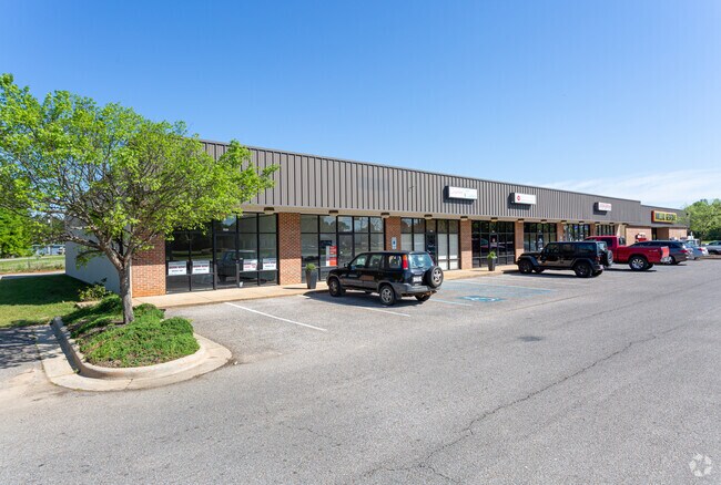
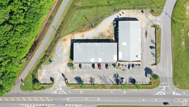
Property Record
1016 Highway 14 W, Prattville, AL 36067
NEARBY LISTINGS FOR SALE OR LEASE
Property Detail
1016 Highway 14 W
Montgomery, AL
Pratt Corner
19-04-20-4-002-002-005-0
LOT 3 PRATT CORNER PLAT NO 1 MAP BK 2005 PG 29114 X 256.13 IRR
Retailwithmorethanonenonretailuse
Autauga
X
Alabama
01001C0361E
3
2025
0.72 AC
2025
Prattville/Millbrook
020600
Montgomery
8,460 SF
DEMOGRAPHICS near 1016 Highway 14 W
1 Mile
3 Mile
5 Mile
2024 Total Population
3,093
16,709
38,858
2029 Population
3,234
17,370
40,357
Pop Growth 2024-2029
+ 4.56%
+ 3.96%
+ 3.86%
Average Age
38
40
39
2024 Total Households
1,171
6,457
15,128
HH Growth 2024-2029
+ 4.53%
+ 3.95%
+ 3.77%
Median Household Inc
$47,094
$55,434
$62,822
Avg Household Size
2.60
2.50
2.50
2024 Avg HH Vehicles
2.00
2.00
2.00
Median Home Value
$151,231
$157,611
$183,769
Median Year Built
1983
1977
1991
Nearby Places
Map Layers
Map Styles
 Street
 Aerial
- Restaurants
- Banks
- Shops
- Fitness
- Groceries
PUBLIC TRANSPORTATION
AIRPORT
Montgomery Regional (Dannelly Field)
DRIVE
WALK
Distance
Montgomery Regional (Dannelly Field)
24 min
17.0 mi
Freight Ports
Port of Mobile
DRIVE
WALK
Distance
Port of Mobile
196 min
177.1 mi
SALE & LEASE HISTORY
LISTING DATE
SALE/LEASE

Sep 25, 2016
For Lease
Nearby Properties
Address
Land Use
TOTAL SIZE
Lot Size
Zoning
Address
Land Use
TOTAL SIZE
Lot Size
Zoning
350,626 SF
31.54 AC
Address
Land Use
TOTAL SIZE
Lot Size
Zoning
84,255 SF
4.19 AC
Address
Land Use
TOTAL SIZE
Lot Size
Zoning
25,521 SF
18 AC
Address
Land Use
TOTAL SIZE
Lot Size
Zoning
33,043 SF
1.30 AC
Address
Land Use
TOTAL SIZE
Lot Size
Zoning
31,020 SF
2.90 AC
Address
Land Use
TOTAL SIZE
Lot Size
Zoning
191.98 AC
Address
Land Use
TOTAL SIZE
Lot Size
Zoning
19.93 AC
Address
Land Use
TOTAL SIZE
Lot Size
Zoning
100,000 SF
6.60 AC
Address
Land Use
TOTAL SIZE
Lot Size
Zoning
37,458 SF
0.74 AC
Address
Land Use
TOTAL SIZE
Lot Size
Zoning
85,080 SF
13.10 AC
Address
Land Use
TOTAL SIZE
Lot Size
Zoning
123,917 SF
25 AC
Address
Land Use
TOTAL SIZE
Lot Size
Zoning
76,340 SF
7.21 AC
Address
Land Use
TOTAL SIZE
Lot Size
Zoning
61,243 SF
5.64 AC
Address
Land Use
TOTAL SIZE
Lot Size
Zoning
38,050 SF
5.80 AC
Address
Land Use
TOTAL SIZE
Lot Size
Zoning
13,029 SF
1.42 AC
Address
Land Use
TOTAL SIZE
Lot Size
Zoning
51,484 SF
7.20 AC
Address
Land Use
TOTAL SIZE
Lot Size
Zoning
Address
Land Use
TOTAL SIZE
Lot Size
Zoning
4,132 SF
2 AC
Address
Land Use
TOTAL SIZE
Lot Size
Zoning
14,447 SF
1.27 AC
Address
Land Use
TOTAL SIZE
Lot Size
Zoning
41,250 SF
6.76 AC
Address
Land Use
TOTAL SIZE
Lot Size
Zoning
4,115 SF
6.99 AC
Address
Land Use
TOTAL SIZE
Lot Size
Zoning
169 AC
Address
Land Use
TOTAL SIZE
Lot Size
Zoning
127,931 SF
10 AC
Address
Land Use
TOTAL SIZE
Lot Size
Zoning
47,400 SF
10 AC
Address
Land Use
TOTAL SIZE
Lot Size
Zoning
5,380 SF
2.01 AC
Address
Land Use
TOTAL SIZE
Lot Size
Zoning
11,525 SF
0.99 AC
Address
Land Use
TOTAL SIZE
Lot Size
Zoning
106,875 SF
2.10 AC
Address
Land Use
TOTAL SIZE
Lot Size
Zoning
51,906 SF
3.98 AC
Address
Land Use
TOTAL SIZE
Lot Size
Zoning
21,777 SF
1.47 AC
The World's #1 Commercial Real Estate Marketplace
Connect with us
© 2025 CoStar Group
The information above has been obtained from sources believed reliable. While we do not doubt its accuracy we have not verified it and make no guarantee, warranty or representation about it. It is your responsibility to independently confirm its accuracy and completeness. Any projections, opinions, assumptions, or estimates used are for example only and do not represent the current or future performance of the property. The value of this transaction to you depends on tax and other factors which should be evaluated by your tax, financial, and legal advisors. You and your advisors should conduct a careful, independent investigation of the property to determine to your satisfaction the suitability of the property for your needs.