Property Record
1016 N 10Th St, Kansas City, KS 66101
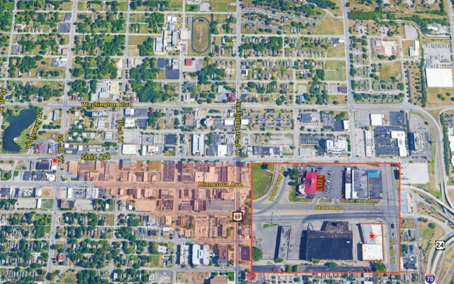

This Property Is For Sale
NEARBY LISTINGS FOR SALE OR LEASE
Property Detail
1016 N 10Th St
Kansas City, MO-KS
Wyandotte City
080398
WYANDOTTE CITY, S4, T11, R4, ACRES 0.29, B120 L1 TO L4
Shipyard
Wyandotte
X
Kansas
20209C0160E
1-4
2025
0.29 AC
2025
Central KC KS/Fairfax
042900
Kansas City
8,157 SF
DEMOGRAPHICS near 1016 N 10Th St
1 Mile
3 Mile
5 Mile
2024 Total Population
18,240
66,761
176,204
2029 Population
17,983
66,240
176,972
Pop Growth 2024-2029
(1.41%)
(0.78%)
+ 0.44%
Average Age
34
35
36
2024 Total Households
5,862
25,155
75,881
HH Growth 2024-2029
(1.42%)
(0.39%)
+ 0.91%
Median Household Inc
$37,197
$48,833
$52,770
Avg Household Size
2.80
2.50
2.20
2024 Avg HH Vehicles
2.00
2.00
2.00
Median Home Value
$108,237
$93,308
$153,924
Median Year Built
1948
1950
1958
Nearby Places
Map Layers
Map Styles
 Street
 Aerial
- Restaurants
- Banks
- Shops
- Fitness
- Groceries
PUBLIC TRANSPORTATION
AIRPORT
Kansas City International
DRIVE
WALK
Distance
Kansas City International
24 min
17.8 mi
Nearby Properties
Address
Land Use
TOTAL SIZE
Lot Size
Zoning
Address
Land Use
TOTAL SIZE
Lot Size
Zoning
568,235 SF
9.59 AC
Address
Land Use
TOTAL SIZE
Lot Size
Zoning
126,962 SF
4.50 AC
KC0
Address
Land Use
TOTAL SIZE
Lot Size
Zoning
132,304 SF
3.72 AC
KCD
Address
Land Use
TOTAL SIZE
Lot Size
Zoning
846,143 SF
51.25 AC
Address
Land Use
TOTAL SIZE
Lot Size
Zoning
277,267 SF
4.18 AC
KCD
Address
Land Use
TOTAL SIZE
Lot Size
Zoning
162,989 SF
3.92 AC
KC0
Address
Land Use
TOTAL SIZE
Lot Size
Zoning
115,627 SF
1.56 AC
Address
Land Use
TOTAL SIZE
Lot Size
Zoning
87,294 SF
0.70 AC
Address
Land Use
TOTAL SIZE
Lot Size
Zoning
4,012,734 SF
574.30 AC
KM3
Address
Land Use
TOTAL SIZE
Lot Size
Zoning
139,499 SF
20.51 AC
KR1B
Address
Land Use
TOTAL SIZE
Lot Size
Zoning
93,870 SF
3.31 AC
KC0
Address
Land Use
TOTAL SIZE
Lot Size
Zoning
122,217 SF
23.87 AC
KR2
Address
Land Use
TOTAL SIZE
Lot Size
Zoning
27,292 SF
10.75 AC
Address
Land Use
TOTAL SIZE
Lot Size
Zoning
75,309 SF
19.40 AC
KR1
Address
Land Use
TOTAL SIZE
Lot Size
Zoning
122,247 SF
11.21 AC
KRP5
Address
Land Use
TOTAL SIZE
Lot Size
Zoning
239,083 SF
85.48 AC
KM3
Address
Land Use
TOTAL SIZE
Lot Size
Zoning
296,548 SF
5.09 AC
Address
Land Use
TOTAL SIZE
Lot Size
Zoning
116,228 SF
0.79 AC
Address
Land Use
TOTAL SIZE
Lot Size
Zoning
52,374 SF
2.88 AC
KRP5
Address
Land Use
TOTAL SIZE
Lot Size
Zoning
132,046 SF
1.95 AC
Address
Land Use
TOTAL SIZE
Lot Size
Zoning
187,460 SF
1.46 AC
Address
Land Use
TOTAL SIZE
Lot Size
Zoning
47,044 SF
2.01 AC
KCD
Address
Land Use
TOTAL SIZE
Lot Size
Zoning
64,031 SF
0.45 AC
Address
Land Use
TOTAL SIZE
Lot Size
Zoning
295,300 SF
1.50 AC
Address
Land Use
TOTAL SIZE
Lot Size
Zoning
37,944 SF
0.68 AC
Address
Land Use
TOTAL SIZE
Lot Size
Zoning
118,336 SF
2.11 AC
Address
Land Use
TOTAL SIZE
Lot Size
Zoning
181,272 SF
3.73 AC
Address
Land Use
TOTAL SIZE
Lot Size
Zoning
946,540 SF
3.25 AC
Address
Land Use
TOTAL SIZE
Lot Size
Zoning
267,620 SF
3.52 AC
Address
Land Use
TOTAL SIZE
Lot Size
Zoning
116,640 SF
3.38 AC
The World's #1 Commercial Real Estate Marketplace
Connect with us
© 2026 CoStar Group
The information above has been obtained from sources believed reliable. While we do not doubt its accuracy we have not verified it and make no guarantee, warranty or representation about it. It is your responsibility to independently confirm its accuracy and completeness. Any projections, opinions, assumptions, or estimates used are for example only and do not represent the current or future performance of the property. The value of this transaction to you depends on tax and other factors which should be evaluated by your tax, financial, and legal advisors. You and your advisors should conduct a careful, independent investigation of the property to determine to your satisfaction the suitability of the property for your needs.