Property Record
1016 N Monroe St, Lowell, MI 49331

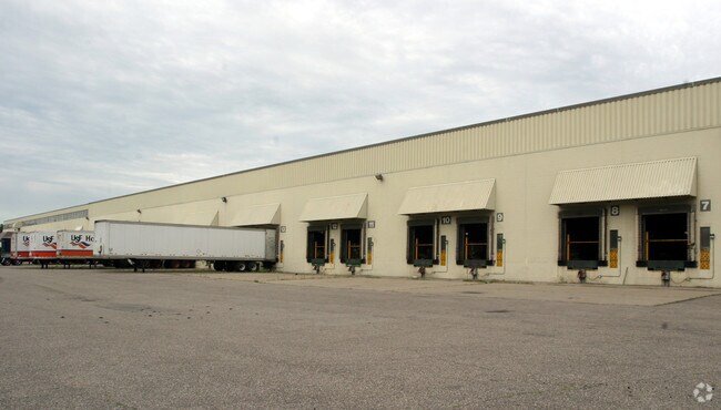
Property Detail
1016 N Monroe St
41-16-35-451-002
PART GOVT LOT 7 COM 693 FT W OF SE COR THEREOF TH N 924 FT TH E 33 FT TH N TO S 1/8 LINE TH W TO CONT 630 FT ON LT BANK OF
Industrialgeneral
Kent
I
Michigan
AE The base floodplain where base flood elevations are provided. AE Zones are now used on new format FIRMs instead of A1-A30 Zones.
7
2024
20.90 AC
2025
Ada/Lowell
012004
West Michigan
460,941 SF
Grand Rapids-Wyoming-Kentwood, MI
NEARBY LISTINGS FOR SALE OR LEASE
DEMOGRAPHICS near 1016 N Monroe St
1 mile
3 mile
5 mile
2025 Total Population
3,296
12,125
17,709
2030 Population
3,408
12,535
18,253
Pop Growth 2025-2030
+ 3.40%
+ 3.38%
+ 3.07%
Average Age
39
40
40
2025 Total Households
1,263
4,600
6,596
HH Growth 2025-2030
+ 3.48%
+ 3.41%
+ 3.11%
Median Household Inc
$79,191
$87,777
$92,075
Avg Household Size
2.50
2.60
2.70
2025 Avg HH Vehicles
2.00
2.00
2.00
Median Home Value
$263,163
$309,121
$328,259
Median Year Built
1976
1984
1984
Nearby Places
Map Layers
Map Styles
 Street
 Aerial
Layers
 Traffic
 Biking
Places
Listings with unknown addresses are not visible on the map
- Restaurants
- Banks
- Shops
- Fitness
- Groceries
PUBLIC TRANSPORTATION
AIRPORT
Gerald R Ford International
Drive
Walk
Distance
Gerald R Ford International
30 min
18.6 mi
Freight Ports
Port of Toledo
Drive
Walk
Distance
Port of Toledo
207 min
178.3 mi
Nearby Properties
Address
Land Use
TOTAL SIZE
Lot Size
Zoning
Address
Land Use
TOTAL SIZE
Lot Size
Zoning
Address
Land Use
TOTAL SIZE
Lot Size
Zoning
196,043 SF
37.61 AC
COMM
Address
Land Use
TOTAL SIZE
Lot Size
Zoning
7.41 AC
COMM
Address
Land Use
TOTAL SIZE
Lot Size
Zoning
177,214 SF
16.91 AC
I
Address
Land Use
TOTAL SIZE
Lot Size
Zoning
50,129 SF
8.07 AC
R-1
Address
Land Use
TOTAL SIZE
Lot Size
Zoning
48,566 SF
3.04 AC
PF
Address
Land Use
TOTAL SIZE
Lot Size
Zoning
2,728 SF
87 SF
MH
Address
Land Use
TOTAL SIZE
Lot Size
Zoning
33,491 SF
Address
Land Use
TOTAL SIZE
Lot Size
Zoning
26,565 SF
Address
Land Use
TOTAL SIZE
Lot Size
Zoning
80,425 SF
13.50 AC
R3
Address
Land Use
TOTAL SIZE
Lot Size
Zoning
56,362 SF
5.03 AC
PUD
Address
Land Use
TOTAL SIZE
Lot Size
Zoning
55,882 SF
5.57 AC
PUD
Address
Land Use
TOTAL SIZE
Lot Size
Zoning
59,440 SF
R-A
Address
Land Use
TOTAL SIZE
Lot Size
Zoning
171,588 SF
19.72 AC
I
Address
Land Use
TOTAL SIZE
Lot Size
Zoning
10.14 AC
Address
Land Use
TOTAL SIZE
Lot Size
Zoning
30,408 SF
2.11 AC
R3
Address
Land Use
TOTAL SIZE
Lot Size
Zoning
34,123 SF
3.10 AC
C3
Address
Land Use
TOTAL SIZE
Lot Size
Zoning
35,889 SF
1.48 AC
I
Address
Land Use
TOTAL SIZE
Lot Size
Zoning
21.45 AC
R2
Address
Land Use
TOTAL SIZE
Lot Size
Zoning
36,440 SF
44 SF
R3
Address
Land Use
TOTAL SIZE
Lot Size
Zoning
16,213 SF
3.73 AC
COMM
Address
Land Use
TOTAL SIZE
Lot Size
Zoning
12.93 AC
Address
Land Use
TOTAL SIZE
Lot Size
Zoning
14,621 SF
2.78 AC
C3
Address
Land Use
TOTAL SIZE
Lot Size
Zoning
14,104 SF
2.33 AC
I
Address
Land Use
TOTAL SIZE
Lot Size
Zoning
4,500 SF
2.55 AC
C2
Address
Land Use
TOTAL SIZE
Lot Size
Zoning
22,321 SF
4.02 AC
AG-2
Address
Land Use
TOTAL SIZE
Lot Size
Zoning
43,120 SF
Address
Land Use
TOTAL SIZE
Lot Size
Zoning
35,616 SF
3.79 AC
R3
Address
Land Use
TOTAL SIZE
Lot Size
Zoning
1,326 SF
3.11 AC
I
The World's #1 Commercial Real Estate Marketplace
Connect with us
© 2026 CoStar Group
The information above has been obtained from sources believed reliable. While we do not doubt its accuracy we have not verified it and make no guarantee, warranty or representation about it. It is your responsibility to independently confirm its accuracy and completeness. Any projections, opinions, assumptions, or estimates used are for example only and do not represent the current or future performance of the property. The value of this transaction to you depends on tax and other factors which should be evaluated by your tax, financial, and legal advisors. You and your advisors should conduct a careful, independent investigation of the property to determine to your satisfaction the suitability of the property for your needs.