Property Record
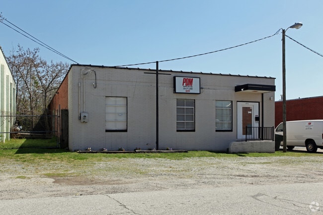
1016 N Raleigh St, Greensboro, NC 27405


Current Lease Availabilities
NEARBY LISTINGS FOR SALE OR LEASE
Property Detail
1016 N Raleigh St
0033611
1016 N RALEIGH ST
Industrialgeneral
Guilford
X
North Carolina
3710787500J
1016
2024
0.28 AC
2025
NE Guilford County
011000
Greensboro/Winston-Salem
6,972 SF
Greensboro-High Point, NC
DEMOGRAPHICS near 1016 N Raleigh St
1 Mile
3 Mile
5 Mile
2024 Total Population
10,162
76,495
162,459
2029 Population
10,235
76,964
162,788
Pop Growth 2024-2029
+ 0.72%
+ 0.61%
+ 0.20%
Average Age
36
35
37
2024 Total Households
3,741
27,883
62,287
HH Growth 2024-2029
+ 0.83%
+ 0.88%
+ 0.30%
Median Household Inc
$27,253
$40,766
$47,597
Avg Household Size
2.50
2.20
2.30
2024 Avg HH Vehicles
1.00
1.00
2.00
Median Home Value
$71,886
$139,445
$171,736
Median Year Built
1970
1969
1974
Nearby Places
Map Layers
Map Styles
 Street
 Aerial
- Restaurants
- Banks
- Shops
- Fitness
- Groceries
PUBLIC TRANSPORTATION
COMMUTER RAIL
Greensboro Station (Piedmont - North Carolina by Train (NC Train))
DRIVE
WALK
Distance
Greensboro Station (Piedmont - North Carolina by Train (NC Train))
5 min
2.7 mi
AIRPORT
Piedmont Triad International
DRIVE
WALK
Distance
Piedmont Triad International
21 min
13.2 mi
Nearby Properties
Address
Land Use
TOTAL SIZE
Lot Size
Zoning
Address
Land Use
TOTAL SIZE
Lot Size
Zoning
908,421 SF
62.30 AC
PI
Address
Land Use
TOTAL SIZE
Lot Size
Zoning
646,229 SF
25.47 AC
LI
Address
Land Use
TOTAL SIZE
Lot Size
Zoning
905,672 SF
28.64 AC
PI
Address
Land Use
TOTAL SIZE
Lot Size
Zoning
388,224 SF
0.98 AC
CB
Address
Land Use
TOTAL SIZE
Lot Size
Zoning
1,546,815 SF
93.94 AC
CU-LI
Address
Land Use
TOTAL SIZE
Lot Size
Zoning
356,139 SF
0.99 AC
CB
Address
Land Use
TOTAL SIZE
Lot Size
Zoning
2.09 AC
CB
Address
Land Use
TOTAL SIZE
Lot Size
Zoning
352,060 SF
3.67 AC
CB
Address
Land Use
TOTAL SIZE
Lot Size
Zoning
364,370 SF
1.85 AC
CB
Address
Land Use
TOTAL SIZE
Lot Size
Zoning
303,490 SF
1.29 AC
CB
Address
Land Use
TOTAL SIZE
Lot Size
Zoning
275,122 SF
0.76 AC
CB
Address
Land Use
TOTAL SIZE
Lot Size
Zoning
413,840 SF
3.68 AC
PI
Address
Land Use
TOTAL SIZE
Lot Size
Zoning
313,033 SF
71.38 AC
O
Address
Land Use
TOTAL SIZE
Lot Size
Zoning
342,490 SF
17.99 AC
PI
Address
Land Use
TOTAL SIZE
Lot Size
Zoning
163,439 SF
4.01 AC
CB
Address
Land Use
TOTAL SIZE
Lot Size
Zoning
163,346 SF
0.92 AC
CB
Address
Land Use
TOTAL SIZE
Lot Size
Zoning
224,444 SF
80.09 AC
PI
Address
Land Use
TOTAL SIZE
Lot Size
Zoning
291,464 SF
17.51 AC
PI
Address
Land Use
TOTAL SIZE
Lot Size
Zoning
275,282 SF
43.43 AC
PI
Address
Land Use
TOTAL SIZE
Lot Size
Zoning
249,779 SF
2.83 AC
CB
Address
Land Use
TOTAL SIZE
Lot Size
Zoning
170,200 SF
1.05 AC
CB
Address
Land Use
TOTAL SIZE
Lot Size
Zoning
661,843 SF
46.38 AC
PI
Address
Land Use
TOTAL SIZE
Lot Size
Zoning
236,374 SF
7.69 AC
CB
Address
Land Use
TOTAL SIZE
Lot Size
Zoning
133,069 SF
7.90 AC
PI
Address
Land Use
TOTAL SIZE
Lot Size
Zoning
231,863 SF
7.96 AC
PUD
Address
Land Use
TOTAL SIZE
Lot Size
Zoning
125,380 SF
4.67 AC
CB
Address
Land Use
TOTAL SIZE
Lot Size
Zoning
148,106 SF
8.02 AC
CB
Address
Land Use
TOTAL SIZE
Lot Size
Zoning
345,087 SF
15.73 AC
PI
Address
Land Use
TOTAL SIZE
Lot Size
Zoning
267,277 SF
12.97 AC
PI
Address
Land Use
TOTAL SIZE
Lot Size
Zoning
176,360 SF
0.81 AC
CB
The World's #1 Commercial Real Estate Marketplace
Connect with us
© 2026 CoStar Group
The information above has been obtained from sources believed reliable. While we do not doubt its accuracy we have not verified it and make no guarantee, warranty or representation about it. It is your responsibility to independently confirm its accuracy and completeness. Any projections, opinions, assumptions, or estimates used are for example only and do not represent the current or future performance of the property. The value of this transaction to you depends on tax and other factors which should be evaluated by your tax, financial, and legal advisors. You and your advisors should conduct a careful, independent investigation of the property to determine to your satisfaction the suitability of the property for your needs.