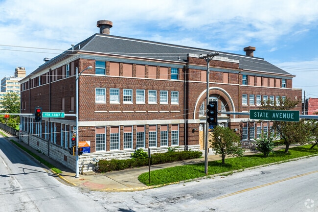
Property Record
1017 N 9Th St, Kansas City, KS 66101


Current Lease Availabilities
NEARBY LISTINGS FOR SALE OR LEASE
Property Detail
1017 N 9Th St
Kansas City, MO-KS
Wyandotte City 0801-0876
081308
WYANDOTTE CITY 0801-0876, S4, T11, R4, ACRES 1.33, B118 L17 TO L27 & 20FT VAC ST ADJ
Publichealthcarefacility
Wyandotte
X
Kansas
20209C0160E
17-27
2025
0.90 AC
2025
Downtown Kansas KC KS
042900
Kansas City
30,400 SF
DEMOGRAPHICS near 1017 N 9Th St
1 Mile
3 Mile
5 Mile
2024 Total Population
16,101
68,989
180,010
2029 Population
15,914
68,513
181,080
Pop Growth 2024-2029
(1.16%)
(0.69%)
+ 0.59%
Average Age
34
35
36
2024 Total Households
5,175
27,068
77,628
HH Growth 2024-2029
(1.14%)
(0.30%)
+ 1.04%
Median Household Inc
$35,700
$50,773
$52,768
Avg Household Size
2.70
2.40
2.20
2024 Avg HH Vehicles
1.00
2.00
2.00
Median Home Value
$100,886
$94,117
$154,936
Median Year Built
1948
1951
1958
Nearby Places
Map Layers
Map Styles
 Street
 Aerial
- Restaurants
- Banks
- Shops
- Fitness
- Groceries
PUBLIC TRANSPORTATION
COMMUTER RAIL
Kansas City (Lincoln Service Missouri River Runner - Amtrak, Missouri River Runner - Amtrak, Southwest Chief - Amtrak)
DRIVE
WALK
Distance
Kansas City (Lincoln Service Missouri River Runner - Amtrak, Missouri River Runner - Amtrak, Southwest Chief - Amtrak)
9 min
4.6 mi
AIRPORT
Kansas City International
DRIVE
WALK
Distance
Kansas City International
25 min
17.7 mi
Freight Ports
Tulsa Port Of Catoosa
DRIVE
WALK
Distance
Tulsa Port Of Catoosa
266 min
238.7 mi
Nearby Properties
Address
Land Use
TOTAL SIZE
Lot Size
Zoning
Address
Land Use
TOTAL SIZE
Lot Size
Zoning
172,810 SF
Address
Land Use
TOTAL SIZE
Lot Size
Zoning
568,235 SF
9.59 AC
Address
Land Use
TOTAL SIZE
Lot Size
Zoning
126,962 SF
4.50 AC
KC0
Address
Land Use
TOTAL SIZE
Lot Size
Zoning
132,304 SF
3.72 AC
KCD
Address
Land Use
TOTAL SIZE
Lot Size
Zoning
846,143 SF
51.25 AC
Address
Land Use
TOTAL SIZE
Lot Size
Zoning
277,042 SF
0.40 AC
Address
Land Use
TOTAL SIZE
Lot Size
Zoning
277,267 SF
4.18 AC
KCD
Address
Land Use
TOTAL SIZE
Lot Size
Zoning
81,578 SF
1.63 AC
Address
Land Use
TOTAL SIZE
Lot Size
Zoning
162,989 SF
3.92 AC
KC0
Address
Land Use
TOTAL SIZE
Lot Size
Zoning
115,627 SF
1.56 AC
Address
Land Use
TOTAL SIZE
Lot Size
Zoning
157,488 SF
1.60 AC
Address
Land Use
TOTAL SIZE
Lot Size
Zoning
87,294 SF
0.70 AC
Address
Land Use
TOTAL SIZE
Lot Size
Zoning
4,012,734 SF
574.30 AC
KM3
Address
Land Use
TOTAL SIZE
Lot Size
Zoning
342,989 SF
1.84 AC
Address
Land Use
TOTAL SIZE
Lot Size
Zoning
139,499 SF
20.51 AC
KR1B
Address
Land Use
TOTAL SIZE
Lot Size
Zoning
93,870 SF
3.31 AC
KC0
Address
Land Use
TOTAL SIZE
Lot Size
Zoning
122,217 SF
23.87 AC
KR2
Address
Land Use
TOTAL SIZE
Lot Size
Zoning
238,003 SF
1.74 AC
Address
Land Use
TOTAL SIZE
Lot Size
Zoning
27,292 SF
10.75 AC
Address
Land Use
TOTAL SIZE
Lot Size
Zoning
50,504 SF
0.39 AC
Address
Land Use
TOTAL SIZE
Lot Size
Zoning
90,023 SF
1.18 AC
Address
Land Use
TOTAL SIZE
Lot Size
Zoning
75,309 SF
19.40 AC
KR1
Address
Land Use
TOTAL SIZE
Lot Size
Zoning
122,247 SF
11.21 AC
KRP5
Address
Land Use
TOTAL SIZE
Lot Size
Zoning
239,083 SF
85.48 AC
KM3
Address
Land Use
TOTAL SIZE
Lot Size
Zoning
296,548 SF
5.09 AC
Address
Land Use
TOTAL SIZE
Lot Size
Zoning
116,228 SF
0.79 AC
Address
Land Use
TOTAL SIZE
Lot Size
Zoning
52,374 SF
2.88 AC
KRP5
Address
Land Use
TOTAL SIZE
Lot Size
Zoning
109,211 SF
0.19 AC
Address
Land Use
TOTAL SIZE
Lot Size
Zoning
132,046 SF
1.95 AC
Address
Land Use
TOTAL SIZE
Lot Size
Zoning
187,460 SF
1.46 AC
The World's #1 Commercial Real Estate Marketplace
Connect with us
© 2026 CoStar Group
The information above has been obtained from sources believed reliable. While we do not doubt its accuracy we have not verified it and make no guarantee, warranty or representation about it. It is your responsibility to independently confirm its accuracy and completeness. Any projections, opinions, assumptions, or estimates used are for example only and do not represent the current or future performance of the property. The value of this transaction to you depends on tax and other factors which should be evaluated by your tax, financial, and legal advisors. You and your advisors should conduct a careful, independent investigation of the property to determine to your satisfaction the suitability of the property for your needs.