Property Record
1017 Odum Rd, Gardendale, AL 35071
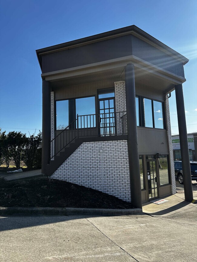
This Property Is For Sale
NEARBY LISTINGS FOR SALE OR LEASE
Property Detail
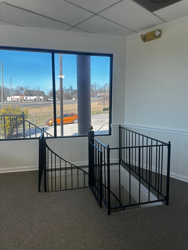
1017 Odum Rd
Birmingham-Hoover, AL
Bermuda Est-Gard 14-14-2
14-00-14-2-002-005.000
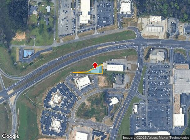
COM AT NW COR OF LOT 6 BERMUDA ESTS ADD TO GARDENDALE TH E 25 FT TO POB TH E 280 FT TH N 100 FT TH SW 195 FT TH SW 130 FT TO POB
Financialbuilding
Jefferson
X
Alabama
01073C0215H
6
2023
0.22 AC
2024
Fultondale
011707
Birmingham
1,476 SF
DEMOGRAPHICS near 1017 Odum Rd
1 Mile
3 Mile
5 Mile
2024 Total Population
2,481
19,617
31,506
2029 Population
2,385
18,937
30,567
Pop Growth 2024-2029
(3.87%)
(3.47%)
(2.98%)
Average Age
41
41
41
2024 Total Households
1,080
7,847
12,827
HH Growth 2024-2029
(3.89%)
(3.58%)
(3.06%)
Median Household Inc
$56,208
$71,117
$68,648
Avg Household Size
2.30
2.50
2.40
2024 Avg HH Vehicles
2.00
2.00
2.00
Median Home Value
$183,423
$187,055
$187,716
Median Year Built
1979
1980
1984
Nearby Places
Map Layers
Map Styles
 Street
 Aerial
- Restaurants
- Banks
- Shops
- Fitness
- Groceries
PUBLIC TRANSPORTATION
AIRPORT
Birmingham-Shuttlesworth International
DRIVE
WALK
Distance
Birmingham-Shuttlesworth International
23 min
16.9 mi
Freight Ports
Port of Mobile
DRIVE
WALK
Distance
Port of Mobile
292 min
266.6 mi
Nearby Properties
Address
Land Use
TOTAL SIZE
Lot Size
Zoning
Address
Land Use
TOTAL SIZE
Lot Size
Zoning
176,544 SF
17 AC
C-2
Address
Land Use
TOTAL SIZE
Lot Size
Zoning
81,419 SF
29.70 AC
R4
Address
Land Use
TOTAL SIZE
Lot Size
Zoning
161,736 SF
6.70 AC
C2
Address
Land Use
TOTAL SIZE
Lot Size
Zoning
203,208 SF
27.37 AC
C2
Address
Land Use
TOTAL SIZE
Lot Size
Zoning
196,498 SF
11.71 AC
R-4
Address
Land Use
TOTAL SIZE
Lot Size
Zoning
46,371 SF
15.90 AC
R4
Address
Land Use
TOTAL SIZE
Lot Size
Zoning
62,430 SF
2.44 AC
C2
Address
Land Use
TOTAL SIZE
Lot Size
Zoning
3.22 AC
INST
Address
Land Use
TOTAL SIZE
Lot Size
Zoning
64,990 SF
4.97 AC
INST
Address
Land Use
TOTAL SIZE
Lot Size
Zoning
84,942 SF
11 AC
I1
Address
Land Use
TOTAL SIZE
Lot Size
Zoning
66,038 SF
3.74 AC
C2
Address
Land Use
TOTAL SIZE
Lot Size
Zoning
104,900 SF
18 AC
B2
Address
Land Use
TOTAL SIZE
Lot Size
Zoning
69,945 SF
10 AC
R4
Address
Land Use
TOTAL SIZE
Lot Size
Zoning
44,859 SF
9.98 AC
C2
Address
Land Use
TOTAL SIZE
Lot Size
Zoning
55,872 SF
5.20 AC
C2
Address
Land Use
TOTAL SIZE
Lot Size
Zoning
59,438 SF
5.10 AC
C2
Address
Land Use
TOTAL SIZE
Lot Size
Zoning
27,112 SF
3.82 AC
C2
Address
Land Use
TOTAL SIZE
Lot Size
Zoning
91,135 SF
4.47 AC
C2
Address
Land Use
TOTAL SIZE
Lot Size
Zoning
39,750 SF
6 AC
C2
Address
Land Use
TOTAL SIZE
Lot Size
Zoning
36,821 SF
3.60 AC
INST
Address
Land Use
TOTAL SIZE
Lot Size
Zoning
46,720 SF
2.59 AC
C2
Address
Land Use
TOTAL SIZE
Lot Size
Zoning
47,959 SF
3.50 AC
C2
Address
Land Use
TOTAL SIZE
Lot Size
Zoning
36,000 SF
3.70 AC
RG/I
Address
Land Use
TOTAL SIZE
Lot Size
Zoning
19,246 SF
1.56 AC
B-2
Address
Land Use
TOTAL SIZE
Lot Size
Zoning
33,598 SF
5 AC
C2
Address
Land Use
TOTAL SIZE
Lot Size
Zoning
22,128 SF
5 AC
C-2
Address
Land Use
TOTAL SIZE
Lot Size
Zoning
13,023 SF
5.10 AC
C2
Address
Land Use
TOTAL SIZE
Lot Size
Zoning
10,077 SF
1.68 AC
C2
Address
Land Use
TOTAL SIZE
Lot Size
Zoning
5,419 SF
3 AC
C2
Address
Land Use
TOTAL SIZE
Lot Size
Zoning
21,695 SF
5.10 AC
C2
The World's #1 Commercial Real Estate Marketplace
Connect with us
© 2026 CoStar Group
The information above has been obtained from sources believed reliable. While we do not doubt its accuracy we have not verified it and make no guarantee, warranty or representation about it. It is your responsibility to independently confirm its accuracy and completeness. Any projections, opinions, assumptions, or estimates used are for example only and do not represent the current or future performance of the property. The value of this transaction to you depends on tax and other factors which should be evaluated by your tax, financial, and legal advisors. You and your advisors should conduct a careful, independent investigation of the property to determine to your satisfaction the suitability of the property for your needs.