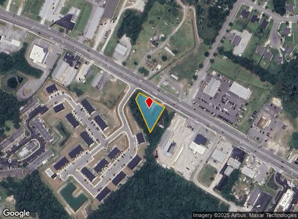
Property Record
1017 W Corbett Ave, Swansboro, NC 28584
Current Lease Availabilities
NEARBY LISTINGS FOR SALE OR LEASE
Property Detail
1017 W Corbett Ave
017332
Meadows Sam B + Lois C (Sur)
Warehouse
PHILLIPS LD NC 24E O2E456
X
Onslow
3720535500K
North Carolina
2025
0.56 AC
2025
Coastal Carolina
000105
Other Market Areas
2,708 SF
Jacksonville, NC
DEMOGRAPHICS near 1017 W Corbett Ave
1 Mile
3 Mile
5 Mile
2024 Total Population
3,222
11,739
27,295
2029 Population
3,443
12,552
28,973
Pop Growth 2024-2029
+ 6.86%
+ 6.93%
+ 6.15%
Average Age
41
40
39
2024 Total Households
1,349
4,756
10,965
HH Growth 2024-2029
+ 7.19%
+ 7.28%
+ 6.40%
Median Household Inc
$58,136
$57,557
$60,966
Avg Household Size
2.40
2.50
2.50
2024 Avg HH Vehicles
2.00
2.00
2.00
Median Home Value
$284,920
$259,056
$240,424
Median Year Built
1998
2000
1997
Nearby Places
- Restaurants
- Banks
- Shops
- Fitness
- Groceries
PUBLIC TRANSPORTATION
AIRPORT
Albert J Ellis
DRIVE
WALK
Distance
Albert J Ellis
51 min
31.6 mi
Coastal Carolina Regional
DRIVE
WALK
Distance
Coastal Carolina Regional
67 min
40.9 mi
Freight Ports
Port of Morehead City
DRIVE
WALK
Distance
Port of Morehead City
43 min
26.6 mi
Nearby Properties
Address
Land Use
TOTAL SIZE
Lot Size
Zoning
Address
Land Use
TOTAL SIZE
Lot Size
Zoning
52,392 SF
84.70 AC
G/E
Address
Land Use
TOTAL SIZE
Lot Size
Zoning
160,815 SF
18.29 AC
B-1
Address
Land Use
TOTAL SIZE
Lot Size
Zoning
26,264 SF
20 AC
B-1
Address
Land Use
TOTAL SIZE
Lot Size
Zoning
73,855 SF
7.51 AC
RA
Address
Land Use
TOTAL SIZE
Lot Size
Zoning
5,332 SF
31.05 AC
G/E
Address
Land Use
TOTAL SIZE
Lot Size
Zoning
10,377 SF
3.83 AC
B-2
Address
Land Use
TOTAL SIZE
Lot Size
Zoning
37,651 SF
21.92 AC
PUD
Address
Land Use
TOTAL SIZE
Lot Size
Zoning
7,400 SF
3.98 AC
B-2
Address
Land Use
TOTAL SIZE
Lot Size
Zoning
63,781 SF
3.09 AC
B-1
Address
Land Use
TOTAL SIZE
Lot Size
Zoning
7,642 SF
3.16 AC
Address
Land Use
TOTAL SIZE
Lot Size
Zoning
28,710 SF
14.32 AC
B-1
Address
Land Use
TOTAL SIZE
Lot Size
Zoning
24,800 SF
2.79 AC
G/E
Address
Land Use
TOTAL SIZE
Lot Size
Zoning
24,311 SF
4.41 AC
B-2
Address
Land Use
TOTAL SIZE
Lot Size
Zoning
24,189 SF
2.63 AC
R-8SF
Address
Land Use
TOTAL SIZE
Lot Size
Zoning
8,884 SF
7.98 AC
B-1
Address
Land Use
TOTAL SIZE
Lot Size
Zoning
5,840 SF
18.07 AC
B-1
Address
Land Use
TOTAL SIZE
Lot Size
Zoning
32,890 SF
6.50 AC
B-1
Address
Land Use
TOTAL SIZE
Lot Size
Zoning
12,870 SF
23 AC
GOV/ED
Address
Land Use
TOTAL SIZE
Lot Size
Zoning
7,200 SF
2.64 AC
B-1
Address
Land Use
TOTAL SIZE
Lot Size
Zoning
2,848 SF
7.06 AC
B-1
Address
Land Use
TOTAL SIZE
Lot Size
Zoning
4,790 SF
0.72 AC
B-2
Address
Land Use
TOTAL SIZE
Lot Size
Zoning
14,040 SF
1.71 AC
B-1
Address
Land Use
TOTAL SIZE
Lot Size
Zoning
14,250 SF
1.27 AC
B-1
Address
Land Use
TOTAL SIZE
Lot Size
Zoning
30,360 SF
5 AC
B-1
Address
Land Use
TOTAL SIZE
Lot Size
Zoning
7,568 SF
30 AC
CON
Address
Land Use
TOTAL SIZE
Lot Size
Zoning
14,742 SF
6.84 AC
B-1
Address
Land Use
TOTAL SIZE
Lot Size
Zoning
8,292 SF
4.08 AC
B-1
Address
Land Use
TOTAL SIZE
Lot Size
Zoning
110.25 AC
CON
Address
Land Use
TOTAL SIZE
Lot Size
Zoning
10,138 SF
1.40 AC
B-1
Address
Land Use
TOTAL SIZE
Lot Size
Zoning
8,366 SF
3.16 AC
B-1
The World's #1 Commercial Real Estate Marketplace
Connect with us
© 2025 CoStar Group
The information above has been obtained from sources believed reliable. While we do not doubt its accuracy we have not verified it and make no guarantee, warranty or representation about it. It is your responsibility to independently confirm its accuracy and completeness. Any projections, opinions, assumptions, or estimates used are for example only and do not represent the current or future performance of the property. The value of this transaction to you depends on tax and other factors which should be evaluated by your tax, financial, and legal advisors. You and your advisors should conduct a careful, independent investigation of the property to determine to your satisfaction the suitability of the property for your needs.