Property Record
1017 W State Highway 152, Mustang, OK 73064


NEARBY LISTINGS FOR SALE OR LEASE
-
-
View all Mustang listings for sale on LoopNet.com
Property Detail
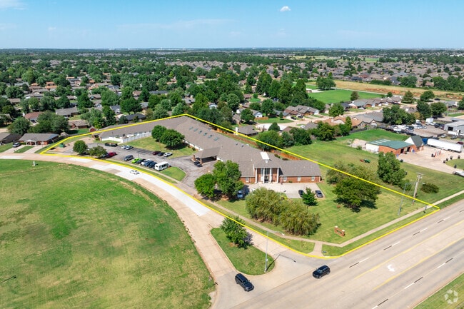
1017 W State Highway 152
Oklahoma City, OK
Westchester
090007126
WESTCHESTER LTS 21, 22 &; 23A-1 BLK 1 BEING ALL LTS 21 &; 22 &; 23 LESS S10 OF LT 23
Retirementnursinghomecombined
Canadian
X
Oklahoma
40027C0025J
21,22
2024
2.77 AC
2025
Canadian County
301407
Oklahoma City
220 SF
DEMOGRAPHICS near 1017 W State Highway 152
1 Mile
3 Mile
5 Mile
2024 Total Population
9,428
24,452
69,585
2029 Population
11,617
30,231
85,093
Pop Growth 2024-2029
+ 23.22%
+ 23.63%
+ 22.29%
Average Age
39
39
37
2024 Total Households
3,478
8,965
25,000
HH Growth 2024-2029
+ 23.12%
+ 23.52%
+ 22.70%
Median Household Inc
$73,913
$87,597
$82,545
Avg Household Size
2.70
2.70
2.70
2024 Avg HH Vehicles
2.00
2.00
2.00
Median Home Value
$178,050
$206,733
$205,042
Median Year Built
1987
1997
2003
Nearby Places
Map Layers
Map Styles
 Street
 Aerial
- Restaurants
- Banks
- Shops
- Fitness
- Groceries
PUBLIC TRANSPORTATION
AIRPORT
Will Rogers World
DRIVE
WALK
Distance
Will Rogers World
24 min
12.4 mi
Freight Ports
Tulsa Port Of Catoosa
DRIVE
WALK
Distance
Tulsa Port Of Catoosa
157 min
143.2 mi
SALE & LEASE HISTORY
LISTING DATE
SALE/LEASE

Aug 09, 2024
For Sale
Nearby Properties
Address
Land Use
TOTAL SIZE
Lot Size
Zoning
Address
Land Use
TOTAL SIZE
Lot Size
Zoning
108,294 SF
75 AC
Address
Land Use
TOTAL SIZE
Lot Size
Zoning
292,053 SF
18.36 AC
Address
Land Use
TOTAL SIZE
Lot Size
Zoning
141,384 SF
38.94 AC
Address
Land Use
TOTAL SIZE
Lot Size
Zoning
130,567 SF
24.06 AC
Address
Land Use
TOTAL SIZE
Lot Size
Zoning
51,628 SF
2.38 AC
Address
Land Use
TOTAL SIZE
Lot Size
Zoning
1,636 SF
0.77 AC
Address
Land Use
TOTAL SIZE
Lot Size
Zoning
57,121 SF
155.38 AC
Address
Land Use
TOTAL SIZE
Lot Size
Zoning
30,650 SF
5 AC
Address
Land Use
TOTAL SIZE
Lot Size
Zoning
13,728 SF
7.70 AC
Address
Land Use
TOTAL SIZE
Lot Size
Zoning
33,313 SF
9.24 AC
Address
Land Use
TOTAL SIZE
Lot Size
Zoning
72,317 SF
21.13 AC
Address
Land Use
TOTAL SIZE
Lot Size
Zoning
17,582 SF
4.34 AC
Address
Land Use
TOTAL SIZE
Lot Size
Zoning
50,402 SF
2.42 AC
Address
Land Use
TOTAL SIZE
Lot Size
Zoning
77,066 SF
5 AC
Address
Land Use
TOTAL SIZE
Lot Size
Zoning
9,800 SF
4.37 AC
Address
Land Use
TOTAL SIZE
Lot Size
Zoning
212,376 SF
9.93 AC
Address
Land Use
TOTAL SIZE
Lot Size
Zoning
17,192 SF
2.32 AC
Address
Land Use
TOTAL SIZE
Lot Size
Zoning
52,605 SF
8.62 AC
Address
Land Use
TOTAL SIZE
Lot Size
Zoning
3,844 SF
5.81 AC
Address
Land Use
TOTAL SIZE
Lot Size
Zoning
16,100 SF
4.20 AC
Address
Land Use
TOTAL SIZE
Lot Size
Zoning
10,871 SF
3.68 AC
Address
Land Use
TOTAL SIZE
Lot Size
Zoning
7,020 SF
0.58 AC
Address
Land Use
TOTAL SIZE
Lot Size
Zoning
2,258 SF
17.93 AC
Address
Land Use
TOTAL SIZE
Lot Size
Zoning
504 SF
16.38 AC
Address
Land Use
TOTAL SIZE
Lot Size
Zoning
280 SF
2.05 AC
Address
Land Use
TOTAL SIZE
Lot Size
Zoning
1,088 SF
13.89 AC
Address
Land Use
TOTAL SIZE
Lot Size
Zoning
7,560 SF
2.64 AC
Address
Land Use
TOTAL SIZE
Lot Size
Zoning
9,960 SF
1.61 AC
Address
Land Use
TOTAL SIZE
Lot Size
Zoning
76,630 SF
7.58 AC
Address
Land Use
TOTAL SIZE
Lot Size
Zoning
13,200 SF
3.69 AC
The World's #1 Commercial Real Estate Marketplace
Connect with us
© 2026 CoStar Group
The information above has been obtained from sources believed reliable. While we do not doubt its accuracy we have not verified it and make no guarantee, warranty or representation about it. It is your responsibility to independently confirm its accuracy and completeness. Any projections, opinions, assumptions, or estimates used are for example only and do not represent the current or future performance of the property. The value of this transaction to you depends on tax and other factors which should be evaluated by your tax, financial, and legal advisors. You and your advisors should conduct a careful, independent investigation of the property to determine to your satisfaction the suitability of the property for your needs.