Property Record
10176 Baltimore National Pike, Ellicott City, MD 21042
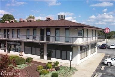
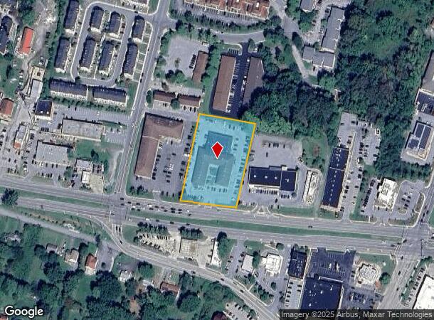
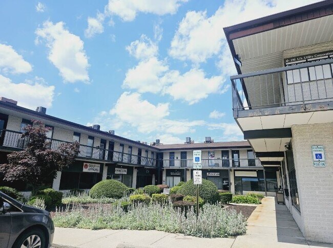

This Property Is For Sale
NEARBY LISTINGS FOR SALE OR LEASE
Property Detail
10176 Baltimore National Pike
Baltimore-Columbia-Towson, MD
Bethany 40 Center Condominium
02-285533
P/O PAR C P/O 2.060A 10176 BALTIMORE NATIONAL PINE ORCHARD PARK
Commercialcondominium
Howard
X
Maryland
24013C0450D
u 101
2024
2.06 AC
2025
Ellicott City
602201
Baltimore
1,697 SF
DEMOGRAPHICS near 10176 Baltimore National Pike
1 Mile
3 Mile
5 Mile
2024 Total Population
7,998
55,049
127,552
2029 Population
8,181
56,582
130,595
Pop Growth 2024-2029
+ 2.29%
+ 2.78%
+ 2.39%
Average Age
41
42
41
2024 Total Households
2,566
19,317
47,565
HH Growth 2024-2029
+ 2.30%
+ 2.90%
+ 2.46%
Median Household Inc
$179,279
$139,015
$127,164
Avg Household Size
3.10
2.80
2.60
2024 Avg HH Vehicles
2.00
2.00
2.00
Median Home Value
$717,176
$671,178
$594,361
Median Year Built
1985
1988
1985
Nearby Places
- Restaurants
- Banks
- Shops
- Fitness
- Groceries
PUBLIC TRANSPORTATION
AIRPORT
Baltimore/Washington International Thurgood Marshall
DRIVE
WALK
Distance
Baltimore/Washington International Thurgood Marshall
28 min
18.9 mi
Ronald Reagan Washington Ntl
DRIVE
WALK
Distance
Ronald Reagan Washington Ntl
59 min
37.4 mi
Freight Ports
Port of Baltimore
DRIVE
WALK
Distance
Port of Baltimore
29 min
17.2 mi
Nearby Properties
Address
Land Use
TOTAL SIZE
Lot Size
Zoning
Address
Land Use
TOTAL SIZE
Lot Size
Zoning
33,342 SF
94.97 AC
RA15
Address
Land Use
TOTAL SIZE
Lot Size
Zoning
1,930 SF
49.68 AC
PSC
Address
Land Use
TOTAL SIZE
Lot Size
Zoning
279,539 SF
68.15 AC
R20
Address
Land Use
TOTAL SIZE
Lot Size
Zoning
279,539 SF
46.77 AC
R20
Address
Land Use
TOTAL SIZE
Lot Size
Zoning
204,875 SF
5.81 AC
POR
Address
Land Use
TOTAL SIZE
Lot Size
Zoning
132,865 SF
27.08 AC
SC
Address
Land Use
TOTAL SIZE
Lot Size
Zoning
166,406 SF
11.22 AC
R20
Address
Land Use
TOTAL SIZE
Lot Size
Zoning
58,644 SF
31.75 AC
B2
Address
Land Use
TOTAL SIZE
Lot Size
Zoning
15,128 SF
10.21 AC
RA15
Address
Land Use
TOTAL SIZE
Lot Size
Zoning
91,716 SF
15.07 AC
POR
Address
Land Use
TOTAL SIZE
Lot Size
Zoning
14,838 SF
14.40 AC
RA15
Address
Land Use
TOTAL SIZE
Lot Size
Zoning
7,292 SF
663.85 AC
RC2
Address
Land Use
TOTAL SIZE
Lot Size
Zoning
1,163 SF
4.49 AC
TOD
Address
Land Use
TOTAL SIZE
Lot Size
Zoning
41,286 SF
12.62 AC
RA15
Address
Land Use
TOTAL SIZE
Lot Size
Zoning
78,366 SF
43.23 AC
RCDEO
Address
Land Use
TOTAL SIZE
Lot Size
Zoning
48,654 SF
11.36 AC
PGCC
Address
Land Use
TOTAL SIZE
Lot Size
Zoning
40,850 SF
8.43 AC
B2
Address
Land Use
TOTAL SIZE
Lot Size
Zoning
66,350 SF
15.88 AC
R20
Address
Land Use
TOTAL SIZE
Lot Size
Zoning
8,208 SF
5.09 AC
RA15
Address
Land Use
TOTAL SIZE
Lot Size
Zoning
14,328 SF
14.18 AC
PGCC
Address
Land Use
TOTAL SIZE
Lot Size
Zoning
23,431 SF
11.27 AC
SC
Address
Land Use
TOTAL SIZE
Lot Size
Zoning
118,125 SF
1.59 AC
M1
Address
Land Use
TOTAL SIZE
Lot Size
Zoning
86,390 SF
4.07 AC
POR
Address
Land Use
TOTAL SIZE
Lot Size
Zoning
100,256 SF
16.29 AC
R20
Address
Land Use
TOTAL SIZE
Lot Size
Zoning
52,280 SF
10.02 AC
B1PEC
Address
Land Use
TOTAL SIZE
Lot Size
Zoning
33,408 SF
3.02 AC
RA15
Address
Land Use
TOTAL SIZE
Lot Size
Zoning
29,696 SF
7.19 AC
B2
Address
Land Use
TOTAL SIZE
Lot Size
Zoning
53,360 SF
5.37 AC
POR
Address
Land Use
TOTAL SIZE
Lot Size
Zoning
16,380 SF
4.31 AC
RA15
Address
Land Use
TOTAL SIZE
Lot Size
Zoning
151,567 SF
18.36 AC
B2
The World's #1 Commercial Real Estate Marketplace
Connect with us
© 2025 CoStar Group
The information above has been obtained from sources believed reliable. While we do not doubt its accuracy we have not verified it and make no guarantee, warranty or representation about it. It is your responsibility to independently confirm its accuracy and completeness. Any projections, opinions, assumptions, or estimates used are for example only and do not represent the current or future performance of the property. The value of this transaction to you depends on tax and other factors which should be evaluated by your tax, financial, and legal advisors. You and your advisors should conduct a careful, independent investigation of the property to determine to your satisfaction the suitability of the property for your needs.