Property Record
10176 Highway 41, Ringgold, GA 30736
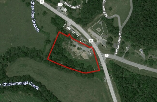
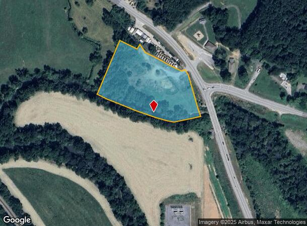
This Property Is For Sale
NEARBY LISTINGS FOR SALE OR LEASE
Property Detail
10176 Highway 41
Chattanooga, TN-GA
Emerald Heights
00660-082
PT LL 203 28/3
Commercialnec
Catoosa
AE
Georgia
13047C0064E
4.90 AC
2024
Catoosa County
2024
Chattanooga
030306
DEMOGRAPHICS near 10176 Highway 41
1 Mile
3 Mile
5 Mile
2024 Total Population
570
6,819
25,211
2029 Population
592
7,093
26,120
Pop Growth 2024-2029
+ 3.86%
+ 4.02%
+ 3.61%
Average Age
44
41
41
2024 Total Households
214
2,636
9,607
HH Growth 2024-2029
+ 3.74%
+ 4.10%
+ 3.65%
Median Household Inc
$66,000
$61,143
$74,526
Avg Household Size
2.60
2.50
2.60
2024 Avg HH Vehicles
2.00
2.00
2.00
Median Home Value
$409,184
$230,872
$260,481
Median Year Built
1997
1993
1991
Nearby Places
Map Layers
Map Styles
 Street
 Aerial
- Restaurants
- Banks
- Shops
- Fitness
- Groceries
PUBLIC TRANSPORTATION
AIRPORT
Lovell Field
DRIVE
WALK
Distance
Lovell Field
25 min
17.0 mi
Freight Ports
Georgia Ports - Savannah
DRIVE
WALK
Distance
Georgia Ports - Savannah
387 min
346.8 mi
Nearby Properties
Address
Land Use
TOTAL SIZE
Lot Size
Zoning
Address
Land Use
TOTAL SIZE
Lot Size
Zoning
5,611 SF
13.92 AC
RIN
Address
Land Use
TOTAL SIZE
Lot Size
Zoning
309,500 SF
35.52 AC
RIN I-1
Address
Land Use
TOTAL SIZE
Lot Size
Zoning
9,672 SF
49 AC
RIN
Address
Land Use
TOTAL SIZE
Lot Size
Zoning
604,939 SF
39.50 AC
RIN I-1
Address
Land Use
TOTAL SIZE
Lot Size
Zoning
319,644 SF
12.59 AC
RIN I-1
Address
Land Use
TOTAL SIZE
Lot Size
Zoning
310,894 SF
54.03 AC
RIN I-1
Address
Land Use
TOTAL SIZE
Lot Size
Zoning
1,680 SF
24.15 AC
A-1
Address
Land Use
TOTAL SIZE
Lot Size
Zoning
193,200 SF
23.12 AC
RIN I-1
Address
Land Use
TOTAL SIZE
Lot Size
Zoning
235,368 SF
16.19 AC
RIN I-1
Address
Land Use
TOTAL SIZE
Lot Size
Zoning
223,680 SF
50.50 AC
RIN I-1
Address
Land Use
TOTAL SIZE
Lot Size
Zoning
88,000 SF
7.16 AC
RIN I-1
Address
Land Use
TOTAL SIZE
Lot Size
Zoning
46,360 SF
1.15 AC
RIN C-2
Address
Land Use
TOTAL SIZE
Lot Size
Zoning
55,060 SF
11.91 AC
RIN C-2
Address
Land Use
TOTAL SIZE
Lot Size
Zoning
40,881 SF
1.36 AC
RIN C-2
Address
Land Use
TOTAL SIZE
Lot Size
Zoning
95,650 SF
23.80 AC
RIN I-1
Address
Land Use
TOTAL SIZE
Lot Size
Zoning
34,927 SF
2.50 AC
RIN C-2
Address
Land Use
TOTAL SIZE
Lot Size
Zoning
28,475 SF
1.65 AC
RIN C-2
Address
Land Use
TOTAL SIZE
Lot Size
Zoning
9,272 SF
1.33 AC
RIN C-3
Address
Land Use
TOTAL SIZE
Lot Size
Zoning
63,987 SF
22.06 AC
RIN I-1
Address
Land Use
TOTAL SIZE
Lot Size
Zoning
4,704 SF
35.21 AC
RIN R-3
Address
Land Use
TOTAL SIZE
Lot Size
Zoning
10,712 SF
39.11 AC
RIN I-1
Address
Land Use
TOTAL SIZE
Lot Size
Zoning
6,624 SF
4.71 AC
RIN R-3
Address
Land Use
TOTAL SIZE
Lot Size
Zoning
45,519 SF
3.52 AC
RIN R-3
Address
Land Use
TOTAL SIZE
Lot Size
Zoning
1,128 SF
44.38 AC
I-1
Address
Land Use
TOTAL SIZE
Lot Size
Zoning
53,207 SF
9.52 AC
RIN I-1
Address
Land Use
TOTAL SIZE
Lot Size
Zoning
21,426 SF
6.72 AC
RIN C-1
Address
Land Use
TOTAL SIZE
Lot Size
Zoning
9,945 SF
2.63 AC
RIN C-2
Address
Land Use
TOTAL SIZE
Lot Size
Zoning
0.71 AC
A-1
Address
Land Use
TOTAL SIZE
Lot Size
Zoning
15,544 SF
1.53 AC
RIN C-3
Address
Land Use
TOTAL SIZE
Lot Size
Zoning
3,286 SF
9.36 AC
RIN C-2
The World's #1 Commercial Real Estate Marketplace
Connect with us
© 2026 CoStar Group
The information above has been obtained from sources believed reliable. While we do not doubt its accuracy we have not verified it and make no guarantee, warranty or representation about it. It is your responsibility to independently confirm its accuracy and completeness. Any projections, opinions, assumptions, or estimates used are for example only and do not represent the current or future performance of the property. The value of this transaction to you depends on tax and other factors which should be evaluated by your tax, financial, and legal advisors. You and your advisors should conduct a careful, independent investigation of the property to determine to your satisfaction the suitability of the property for your needs.