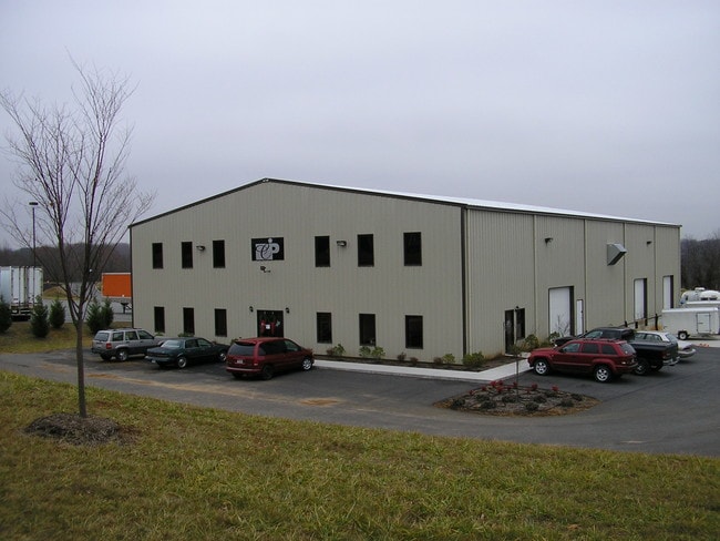
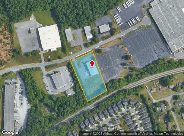
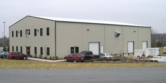
Property Record
1018 Dillard Dr, Forest, VA 24551
NEARBY LISTINGS FOR SALE OR LEASE
Property Detail
1018 Dillard Dr
Lynchburg, VA
Wyndhurst Industrial Corridor
242-13-007
GREENSTONE COMMERICAL CENTER, SEC 3, LOT 7A
Warehouse
Lynchburg City
X
Virginia
51019C0400D
7a
2025
2.40 AC
2025
Lynchburg
001800
Other Market Areas
10,000 SF
DEMOGRAPHICS near 1018 Dillard Dr
1 mile
3 mile
5 mile
2024 Total Population
4,338
40,074
81,581
2029 Population
4,377
40,433
82,209
Pop Growth 2024-2029
+ 0.90%
+ 0.90%
+ 0.77%
Average Age
39
38
38
2024 Total Households
1,894
17,220
33,113
HH Growth 2024-2029
+ 0.79%
+ 0.88%
+ 0.70%
Median Household Inc
$66,215
$62,455
$64,079
Avg Household Size
2.20
2.30
2.30
2024 Avg HH Vehicles
2.00
2.00
2.00
Median Home Value
$213,889
$199,267
$216,589
Median Year Built
2000
1987
1982
Nearby Places
Map Layers
Map Styles
 Street
 Aerial
Transit
 Traffic
 Biking
Places
Listings with unknown addresses are not visible on the map
- Restaurants
- Banks
- Shops
- Fitness
- Groceries
PUBLIC TRANSPORTATION
COMMUTER RAIL
Drive
Walk
Distance
17 min
7.6 mi
AIRPORT
Lynchburg Regional/Preston Glenn Field
Drive
Walk
Distance
Lynchburg Regional/Preston Glenn Field
15 min
5.3 mi
SALE & LEASE HISTORY
LISTING DATE
SALE/LEASE

Dec 13, 2016
For Lease
Dec 09, 2016
For Sale
Nearby Properties
Address
Land Use
TOTAL SIZE
Lot Size
Zoning
Address
Land Use
TOTAL SIZE
Lot Size
Zoning
3.33 AC
1909
Address
Land Use
TOTAL SIZE
Lot Size
Zoning
22.70 AC
Address
Land Use
TOTAL SIZE
Lot Size
Zoning
912 SF
52.88 AC
BGC
Address
Land Use
TOTAL SIZE
Lot Size
Zoning
326,293 SF
80.06 AC
R1R3
Address
Land Use
TOTAL SIZE
Lot Size
Zoning
1,282 SF
12.75 AC
Address
Land Use
TOTAL SIZE
Lot Size
Zoning
207,379 SF
10.24 AC
250905
Address
Land Use
TOTAL SIZE
Lot Size
Zoning
199,056 SF
16.21 AC
R1
Address
Land Use
TOTAL SIZE
Lot Size
Zoning
181,808 SF
39.61 AC
192921
Address
Land Use
TOTAL SIZE
Lot Size
Zoning
1,241 SF
7.20 AC
2519
Address
Land Use
TOTAL SIZE
Lot Size
Zoning
36,168 SF
7.96 AC
BGC
Address
Land Use
TOTAL SIZE
Lot Size
Zoning
415,272 SF
117.43 AC
I3RC
Address
Land Use
TOTAL SIZE
Lot Size
Zoning
155,125 SF
38.67 AC
250129
Address
Land Use
TOTAL SIZE
Lot Size
Zoning
9,508 SF
8.54 AC
RMF
Address
Land Use
TOTAL SIZE
Lot Size
Zoning
161,688 SF
16.57 AC
R3RC
Address
Land Use
TOTAL SIZE
Lot Size
Zoning
222,427 SF
23.56 AC
I2RC
Address
Land Use
TOTAL SIZE
Lot Size
Zoning
1,120 SF
16.81 AC
RMF
Address
Land Use
TOTAL SIZE
Lot Size
Zoning
3,478 SF
13.10 AC
RMFC
Address
Land Use
TOTAL SIZE
Lot Size
Zoning
537,608 SF
47.65 AC
152919
Address
Land Use
TOTAL SIZE
Lot Size
Zoning
10.84 AC
R4RC
Address
Land Use
TOTAL SIZE
Lot Size
Zoning
94,608 SF
57.36 AC
2523
Address
Land Use
TOTAL SIZE
Lot Size
Zoning
8.29 AC
R3
Address
Land Use
TOTAL SIZE
Lot Size
Zoning
65,062 SF
6.39 AC
B5
Address
Land Use
TOTAL SIZE
Lot Size
Zoning
151,200 SF
24.18 AC
I1
Address
Land Use
TOTAL SIZE
Lot Size
Zoning
161,333 SF
10.60 AC
2119
Address
Land Use
TOTAL SIZE
Lot Size
Zoning
192,704 SF
8.35 AC
252905
Address
Land Use
TOTAL SIZE
Lot Size
Zoning
143,154 SF
15.37 AC
R5RC
Address
Land Use
TOTAL SIZE
Lot Size
Zoning
Address
Land Use
TOTAL SIZE
Lot Size
Zoning
47,505 SF
9.32 AC
I1
Address
Land Use
TOTAL SIZE
Lot Size
Zoning
76,421 SF
25.07 AC
R2RC
Address
Land Use
TOTAL SIZE
Lot Size
Zoning
183,505 SF
21.11 AC
252919
The World's #1 Commercial Real Estate Marketplace
Connect with us
© 2026 CoStar Group
The information above has been obtained from sources believed reliable. While we do not doubt its accuracy we have not verified it and make no guarantee, warranty or representation about it. It is your responsibility to independently confirm its accuracy and completeness. Any projections, opinions, assumptions, or estimates used are for example only and do not represent the current or future performance of the property. The value of this transaction to you depends on tax and other factors which should be evaluated by your tax, financial, and legal advisors. You and your advisors should conduct a careful, independent investigation of the property to determine to your satisfaction the suitability of the property for your needs.