Property Record
1018 E 20Th St, Upland, CA 91784
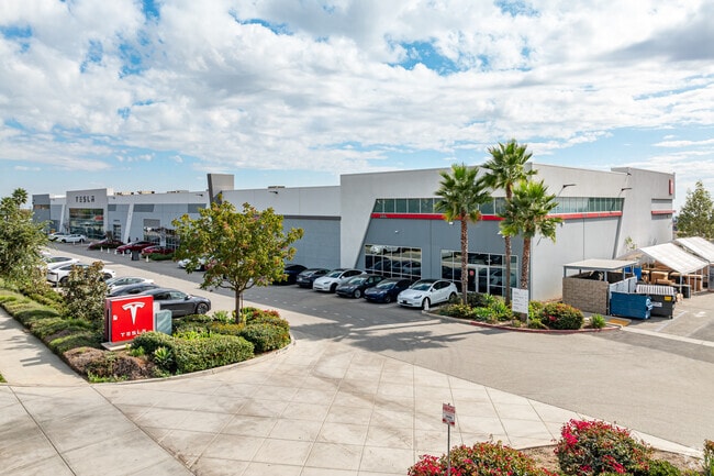

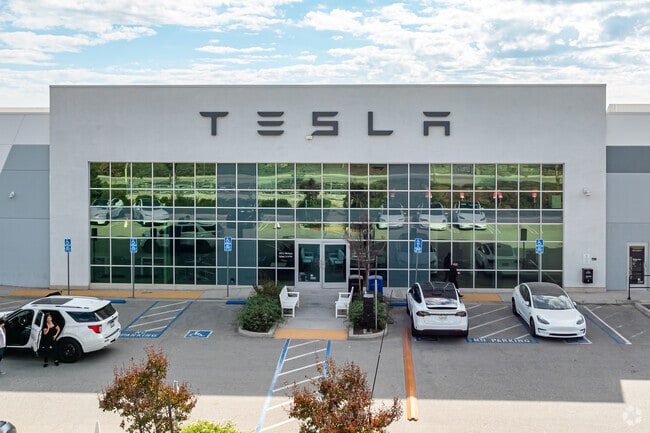
Property Detail
1018 E 20Th St
Riverside-San Bernardino-Ontario, CA
PARCEL 1 AND 2 OF PARCEL MAP NO. 17447, IN THE CITY OF UPLAND, COUNTY OF SAN BERNARDINO, STATE OF CALIFORNIA, AS SHOWN ON MAP RECORDED IN BOOK 238, PAGES 87 AND 88 OF PARCEL MAPS, IN THE OFFICE OF THE COUNTY RECORDER OF SAID COUNTY TOGETHER WITH THAT
1044-111-51
SAN BERNARDINO
Vehiclerentalsvehiclesales
California
B and X Area of moderate flood hazard, usually the area between the limits of the 100-year and 500-year floods.
l
2025
3.51 AC
2025
Upland/Montclair
000820
Inland Empire (California)
48,708 SF
NEARBY LISTINGS FOR SALE OR LEASE
DEMOGRAPHICS near 1018 E 20Th St
1 mile
3 mile
5 mile
2025 Total Population
9,440
110,122
287,463
2030 Population
9,514
110,669
289,072
Pop Growth 2025-2030
+ 0.78%
+ 0.50%
+ 0.56%
Average Age
44
42
39
2025 Total Households
3,213
39,025
94,706
HH Growth 2025-2030
+ 0.68%
+ 0.50%
+ 0.58%
Median Household Inc
$166,322
$114,246
$101,179
Avg Household Size
2.90
2.80
2.90
2025 Avg HH Vehicles
3.00
2.00
2.00
Median Home Value
$821,391
$760,641
$736,787
Median Year Built
1983
1977
1978
Nearby Places
Map Layers
Map Styles
 Street
 Aerial
Transit
 Traffic
 Biking
Places
Listings with unknown addresses are not visible on the map
- Restaurants
- Banks
- Shops
- Fitness
- Groceries
PUBLIC TRANSPORTATION
COMMUTER RAIL
Upland (San Bernardino Line - Southern California Regional Rail Authority (Metrolink))
Drive
Walk
Distance
Upland (San Bernardino Line - Southern California Regional Rail Authority (Metrolink))
7 min
3.7 mi
Montclair (San Bernardino Line - Southern California Regional Rail Authority (Metrolink))
Drive
Walk
Distance
Montclair (San Bernardino Line - Southern California Regional Rail Authority (Metrolink))
11 min
6.7 mi
AIRPORT
Ontario International
Drive
Walk
Distance
Ontario International
14 min
7.4 mi
Freight Ports
Port of Long Beach
Drive
Walk
Distance
Port of Long Beach
66 min
54.2 mi
SALE & LEASE HISTORY
LISTING DATE
SALE/LEASE

Jun 28, 2018
For Lease
Nearby Properties
Address
Land Use
TOTAL SIZE
Lot Size
Zoning
Address
Land Use
TOTAL SIZE
Lot Size
Zoning
376,610 SF
25.22 AC
Address
Land Use
TOTAL SIZE
Lot Size
Zoning
167,512 SF
8.35 AC
Address
Land Use
TOTAL SIZE
Lot Size
Zoning
251,645 SF
4.50 AC
Address
Land Use
TOTAL SIZE
Lot Size
Zoning
340,104 SF
8.95 AC
Address
Land Use
TOTAL SIZE
Lot Size
Zoning
249,672 SF
13.80 AC
Address
Land Use
TOTAL SIZE
Lot Size
Zoning
95,240 SF
8.42 AC
Address
Land Use
TOTAL SIZE
Lot Size
Zoning
203,092 SF
10 AC
Address
Land Use
TOTAL SIZE
Lot Size
Zoning
63,862 SF
4.77 AC
Address
Land Use
TOTAL SIZE
Lot Size
Zoning
455,226 SF
18.15 AC
Address
Land Use
TOTAL SIZE
Lot Size
Zoning
171,446 SF
10.88 AC
Address
Land Use
TOTAL SIZE
Lot Size
Zoning
54,166 SF
4.60 AC
Address
Land Use
TOTAL SIZE
Lot Size
Zoning
59,690 SF
3.32 AC
Address
Land Use
TOTAL SIZE
Lot Size
Zoning
54,366 SF
4.95 AC
Address
Land Use
TOTAL SIZE
Lot Size
Zoning
75,755 SF
3.23 AC
Address
Land Use
TOTAL SIZE
Lot Size
Zoning
145,880 SF
9.76 AC
Address
Land Use
TOTAL SIZE
Lot Size
Zoning
56,467 SF
8.78 AC
Address
Land Use
TOTAL SIZE
Lot Size
Zoning
293,200 SF
17.06 AC
Address
Land Use
TOTAL SIZE
Lot Size
Zoning
122,600 SF
5.94 AC
Address
Land Use
TOTAL SIZE
Lot Size
Zoning
61,791 SF
2.68 AC
Address
Land Use
TOTAL SIZE
Lot Size
Zoning
159,848 SF
5.30 AC
Address
Land Use
TOTAL SIZE
Lot Size
Zoning
125,452 SF
4.07 AC
Address
Land Use
TOTAL SIZE
Lot Size
Zoning
50,886 SF
4.94 AC
Address
Land Use
TOTAL SIZE
Lot Size
Zoning
38,014 SF
2.02 AC
Address
Land Use
TOTAL SIZE
Lot Size
Zoning
91,796 SF
3.10 AC
Address
Land Use
TOTAL SIZE
Lot Size
Zoning
89,952 SF
8.14 AC
Address
Land Use
TOTAL SIZE
Lot Size
Zoning
41,286 SF
2.50 AC
Address
Land Use
TOTAL SIZE
Lot Size
Zoning
88,488 SF
4.07 AC
Address
Land Use
TOTAL SIZE
Lot Size
Zoning
17,984 SF
9.07 AC
Address
Land Use
TOTAL SIZE
Lot Size
Zoning
125,455 SF
13.03 AC
Address
Land Use
TOTAL SIZE
Lot Size
Zoning
163,064 SF
8.28 AC
The World's #1 Commercial Real Estate Marketplace
Connect with us
© 2026 CoStar Group
The information above has been obtained from sources believed reliable. While we do not doubt its accuracy we have not verified it and make no guarantee, warranty or representation about it. It is your responsibility to independently confirm its accuracy and completeness. Any projections, opinions, assumptions, or estimates used are for example only and do not represent the current or future performance of the property. The value of this transaction to you depends on tax and other factors which should be evaluated by your tax, financial, and legal advisors. You and your advisors should conduct a careful, independent investigation of the property to determine to your satisfaction the suitability of the property for your needs.