Property Record
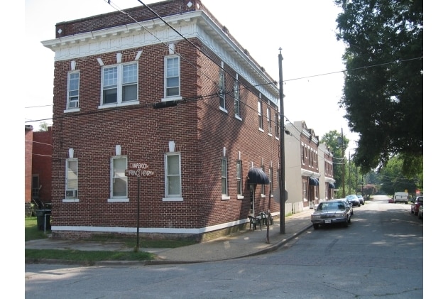
1018 Maplewood Ave, Hopewell, VA 23860


NEARBY LISTINGS FOR SALE OR LEASE
-
-
View all Hopewell listings for sale on LoopNet.com
Property Detail
1018 Maplewood Ave
Richmond, VA
City Point
027-0220
LOTS 15-19 INCL
Multifamilydwelling
Hopewell City
X
Virginia
51041C0360E
15-19
2025
0.24 AC
2025
Hopewell County
820100
Richmond VA
DEMOGRAPHICS near 1018 Maplewood Ave
1 Mile
3 Mile
5 Mile
2024 Total Population
1,847
17,195
46,572
2029 Population
1,859
17,277
47,670
Pop Growth 2024-2029
+ 0.65%
+ 0.48%
+ 2.36%
Average Age
38
39
40
2024 Total Households
814
7,010
16,740
HH Growth 2024-2029
+ 0.74%
+ 0.47%
+ 2.32%
Median Household Inc
$34,860
$44,175
$61,243
Avg Household Size
2.30
2.40
2.50
2024 Avg HH Vehicles
1.00
2.00
2.00
Median Home Value
$147,159
$136,158
$202,920
Median Year Built
1960
1966
1978
Nearby Places
Map Layers
Map Styles
 Street
 Aerial
- Restaurants
- Banks
- Shops
- Fitness
- Groceries
PUBLIC TRANSPORTATION
AIRPORT
Richmond International
DRIVE
WALK
Distance
Richmond International
31 min
21.4 mi
Freight Ports
Virginia Port Authority - Richmond
DRIVE
WALK
Distance
Virginia Port Authority - Richmond
28 min
18.4 mi
SALE & LEASE HISTORY
LISTING DATE
SALE/LEASE

Sep 23, 2016
For Sale
Sep 23, 2016
For Sale
Nearby Properties
Address
Land Use
TOTAL SIZE
Lot Size
Zoning
Address
Land Use
TOTAL SIZE
Lot Size
Zoning
252,000 SF
118.66 AC
I3 - HVY I
Address
Land Use
TOTAL SIZE
Lot Size
Zoning
164.03 AC
M2
Address
Land Use
TOTAL SIZE
Lot Size
Zoning
137.06 AC
M2
Address
Land Use
TOTAL SIZE
Lot Size
Zoning
12,840 SF
389 AC
M2
Address
Land Use
TOTAL SIZE
Lot Size
Zoning
459.55 AC
I3 - HVY I
Address
Land Use
TOTAL SIZE
Lot Size
Zoning
177,075 SF
110.41 AC
R2
Address
Land Use
TOTAL SIZE
Lot Size
Zoning
1,512 SF
141.06 AC
TH
Address
Land Use
TOTAL SIZE
Lot Size
Zoning
91,105 SF
10.90 AC
C3 - COMMU
Address
Land Use
TOTAL SIZE
Lot Size
Zoning
13.70 AC
B2
Address
Land Use
TOTAL SIZE
Lot Size
Zoning
702 SF
34.72 AC
M2
Address
Land Use
TOTAL SIZE
Lot Size
Zoning
219 SF
74.95 AC
I3 - HVY I
Address
Land Use
TOTAL SIZE
Lot Size
Zoning
356.70 AC
I3 - HVY I
Address
Land Use
TOTAL SIZE
Lot Size
Zoning
228,108 SF
19.32 AC
I1 - LT IN
Address
Land Use
TOTAL SIZE
Lot Size
Zoning
35,173 SF
19.30 AC
C3 - COMMU
Address
Land Use
TOTAL SIZE
Lot Size
Zoning
10.09 AC
R4
Address
Land Use
TOTAL SIZE
Lot Size
Zoning
29,585 SF
5.67 AC
R4
Address
Land Use
TOTAL SIZE
Lot Size
Zoning
296.90 AC
I3 - HVY I
Address
Land Use
TOTAL SIZE
Lot Size
Zoning
8,000 SF
52.80 AC
M2
Address
Land Use
TOTAL SIZE
Lot Size
Zoning
35,224 SF
3.87 AC
B1
Address
Land Use
TOTAL SIZE
Lot Size
Zoning
11,250 SF
7.36 AC
M2
Address
Land Use
TOTAL SIZE
Lot Size
Zoning
196.75 AC
A - AGRICU
Address
Land Use
TOTAL SIZE
Lot Size
Zoning
45,515 SF
4.28 AC
B2
Address
Land Use
TOTAL SIZE
Lot Size
Zoning
79,889 SF
16.67 AC
R3
Address
Land Use
TOTAL SIZE
Lot Size
Zoning
107.38 AC
M2
Address
Land Use
TOTAL SIZE
Lot Size
Zoning
0.25 AC
B1
Address
Land Use
TOTAL SIZE
Lot Size
Zoning
59,850 SF
3.33 AC
C5 - GEN B
Address
Land Use
TOTAL SIZE
Lot Size
Zoning
262.64 AC
I3 - HVY I
Address
Land Use
TOTAL SIZE
Lot Size
Zoning
4.20 AC
R4
Address
Land Use
TOTAL SIZE
Lot Size
Zoning
19,638 SF
3.32 AC
M2
Address
Land Use
TOTAL SIZE
Lot Size
Zoning
12.46 AC
R4
The World's #1 Commercial Real Estate Marketplace
Connect with us
© 2026 CoStar Group
The information above has been obtained from sources believed reliable. While we do not doubt its accuracy we have not verified it and make no guarantee, warranty or representation about it. It is your responsibility to independently confirm its accuracy and completeness. Any projections, opinions, assumptions, or estimates used are for example only and do not represent the current or future performance of the property. The value of this transaction to you depends on tax and other factors which should be evaluated by your tax, financial, and legal advisors. You and your advisors should conduct a careful, independent investigation of the property to determine to your satisfaction the suitability of the property for your needs.