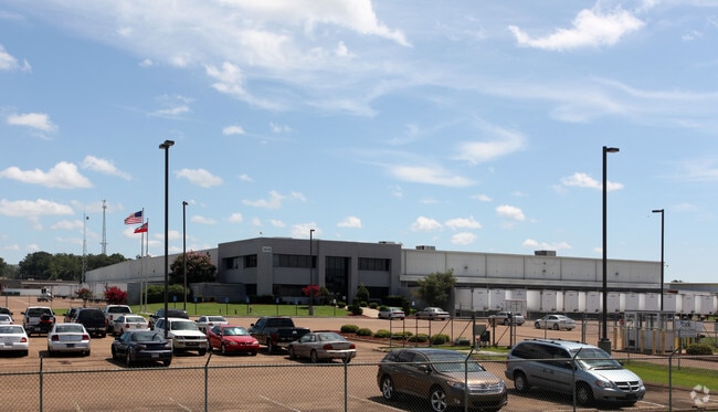
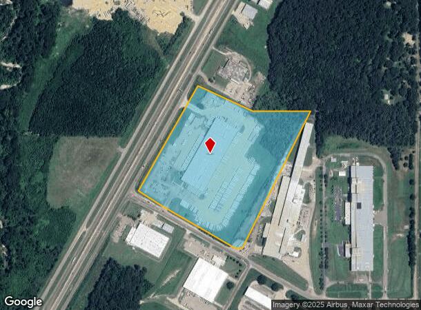
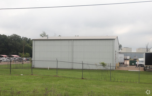
Property Record
1018 Mendell Davis Dr, Byram, MS 39272
NEARBY LISTINGS FOR SALE OR LEASE
Property Detail
1018 Mendell Davis Dr
4851-0379-004
BEG INT N/L MENDELL DAVIS DR & E/L HWY 55 ELY 1050 FT NLY 1490 FT W 550 FT NWLY 580 FT TO E/L HWY 55 SWLY ALG HWY 1185 FT TO POB IN SE 1/4 SEC 23 & SW 1/4 SEC 24 T4 R1W LEASE EXPIRES 12-31-2015
Storebuilding
Hinds
X
Mississippi
28121C0295F
30.67 AC
2024
Outlying Hinds County
2025
Jackson
011103
Jackson, MS
173,863 SF
DEMOGRAPHICS near 1018 Mendell Davis Dr
1 Mile
3 Mile
5 Mile
2024 Total Population
153
10,965
20,987
2029 Population
146
10,213
19,617
Pop Growth 2024-2029
(4.58%)
(6.86%)
(6.53%)
Average Age
38
37
39
2024 Total Households
61
4,298
8,225
HH Growth 2024-2029
(4.92%)
(7.17%)
(6.74%)
Median Household Inc
$63,214
$64,370
$67,348
Avg Household Size
2.40
2.50
2.50
2024 Avg HH Vehicles
2.00
2.00
2.00
Median Home Value
$147,561
$157,421
$162,896
Median Year Built
1998
1997
1994
Nearby Places
Map Layers
Map Styles
 Street
 Aerial
- Restaurants
- Banks
- Shops
- Fitness
- Groceries
PUBLIC TRANSPORTATION
AIRPORT
Jackson-Medgar Wiley Evers International
DRIVE
WALK
Distance
Jackson-Medgar Wiley Evers International
29 min
19.4 mi
Freight Ports
Port of Greater Baton Rouge
DRIVE
WALK
Distance
Port of Greater Baton Rouge
188 min
167.8 mi
Nearby Properties
Address
Land Use
TOTAL SIZE
Lot Size
Zoning
Address
Land Use
TOTAL SIZE
Lot Size
Zoning
110,876 SF
8.80 AC
Address
Land Use
TOTAL SIZE
Lot Size
Zoning
489,330 SF
27.90 AC
Address
Land Use
TOTAL SIZE
Lot Size
Zoning
257,600 SF
25.90 AC
Address
Land Use
TOTAL SIZE
Lot Size
Zoning
288.50 AC
Address
Land Use
TOTAL SIZE
Lot Size
Zoning
232,136 SF
16.06 AC
Address
Land Use
TOTAL SIZE
Lot Size
Zoning
190,029 SF
24.47 AC
Address
Land Use
TOTAL SIZE
Lot Size
Zoning
31,980 SF
9.10 AC
Address
Land Use
TOTAL SIZE
Lot Size
Zoning
Address
Land Use
TOTAL SIZE
Lot Size
Zoning
229,741 SF
17.28 AC
Address
Land Use
TOTAL SIZE
Lot Size
Zoning
34,900 SF
6.60 AC
Address
Land Use
TOTAL SIZE
Lot Size
Zoning
351,384 SF
16.69 AC
Address
Land Use
TOTAL SIZE
Lot Size
Zoning
136,190 SF
10.06 AC
Address
Land Use
TOTAL SIZE
Lot Size
Zoning
45.60 AC
Address
Land Use
TOTAL SIZE
Lot Size
Zoning
18,200 SF
1.66 AC
Address
Land Use
TOTAL SIZE
Lot Size
Zoning
134,417 SF
10 AC
Address
Land Use
TOTAL SIZE
Lot Size
Zoning
25,880 SF
5.47 AC
Address
Land Use
TOTAL SIZE
Lot Size
Zoning
Address
Land Use
TOTAL SIZE
Lot Size
Zoning
230,745 SF
18.40 AC
Address
Land Use
TOTAL SIZE
Lot Size
Zoning
Address
Land Use
TOTAL SIZE
Lot Size
Zoning
Address
Land Use
TOTAL SIZE
Lot Size
Zoning
222,160 SF
37.66 AC
Address
Land Use
TOTAL SIZE
Lot Size
Zoning
94,621 SF
23.37 AC
Address
Land Use
TOTAL SIZE
Lot Size
Zoning
29.50 AC
Address
Land Use
TOTAL SIZE
Lot Size
Zoning
Address
Land Use
TOTAL SIZE
Lot Size
Zoning
68,315 SF
6.36 AC
Address
Land Use
TOTAL SIZE
Lot Size
Zoning
12,500 SF
3.40 AC
Address
Land Use
TOTAL SIZE
Lot Size
Zoning
11,260 SF
1.86 AC
Address
Land Use
TOTAL SIZE
Lot Size
Zoning
37,542 SF
3.50 AC
Address
Land Use
TOTAL SIZE
Lot Size
Zoning
129,400 SF
11.80 AC
The World's #1 Commercial Real Estate Marketplace
Connect with us
© 2025 CoStar Group
The information above has been obtained from sources believed reliable. While we do not doubt its accuracy we have not verified it and make no guarantee, warranty or representation about it. It is your responsibility to independently confirm its accuracy and completeness. Any projections, opinions, assumptions, or estimates used are for example only and do not represent the current or future performance of the property. The value of this transaction to you depends on tax and other factors which should be evaluated by your tax, financial, and legal advisors. You and your advisors should conduct a careful, independent investigation of the property to determine to your satisfaction the suitability of the property for your needs.