Property Record
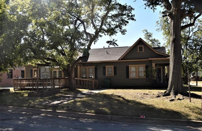
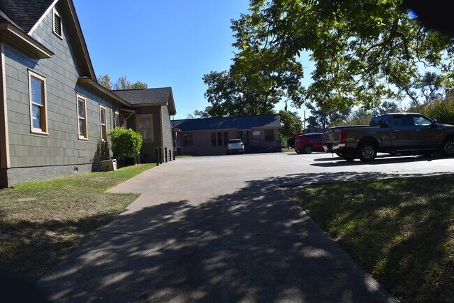
1018 N Mallard St, Palestine, TX 75801

Property Detail
1018 N Mallard St
Palestine, TX
ORIGINAL BLOCK 91-N1/2 LOT 1 & 2B
R34131
Anderson
Commercialnec
Texas
B and X Area of moderate flood hazard, usually the area between the limits of the 100-year and 500-year floods.
1
2025
0.24 AC
2025
Texas East Area
950500
Other Market Areas
1,880 SF
NEARBY LISTINGS FOR SALE OR LEASE
DEMOGRAPHICS near 1018 N Mallard St
1 mile
3 mile
5 mile
2024 Total Population
4,374
18,418
25,251
2029 Population
4,417
18,616
25,516
Pop Growth 2024-2029
+ 0.98%
+ 1.08%
+ 1.05%
Average Age
37
39
39
2024 Total Households
1,624
5,979
8,503
HH Growth 2024-2029
+ 0.86%
+ 1.07%
+ 1.01%
Median Household Inc
$37,721
$39,434
$42,128
Avg Household Size
2.60
2.60
2.60
2024 Avg HH Vehicles
1.00
2.00
2.00
Median Home Value
$87,189
$108,147
$120,744
Median Year Built
1973
1976
1979
Nearby Places
Map Layers
Map Styles
 Street
 Aerial
Transit
 Traffic
 Biking
Places
Listings with unknown addresses are not visible on the map
- Restaurants
- Banks
- Shops
- Fitness
- Groceries
SALE & LEASE HISTORY
LISTING DATE
SALE/LEASE

Nov 10, 2022
For Sale
Mar 03, 2017
For Sale
Dec 12, 2016
For Lease
Nearby Properties
Address
Land Use
TOTAL SIZE
Lot Size
Zoning
Address
Land Use
TOTAL SIZE
Lot Size
Zoning
Address
Land Use
TOTAL SIZE
Lot Size
Zoning
335,801 SF
24.72 AC
Address
Land Use
TOTAL SIZE
Lot Size
Zoning
189,215 SF
20.10 AC
Address
Land Use
TOTAL SIZE
Lot Size
Zoning
79,260 SF
4.99 AC
Address
Land Use
TOTAL SIZE
Lot Size
Zoning
714,542 SF
42.62 AC
Address
Land Use
TOTAL SIZE
Lot Size
Zoning
74,694 SF
14.56 AC
Address
Land Use
TOTAL SIZE
Lot Size
Zoning
47,006 SF
16.53 AC
Address
Land Use
TOTAL SIZE
Lot Size
Zoning
128,411 SF
11.21 AC
Address
Land Use
TOTAL SIZE
Lot Size
Zoning
200,254 SF
30.23 AC
Address
Land Use
TOTAL SIZE
Lot Size
Zoning
55,418 SF
46.17 AC
Address
Land Use
TOTAL SIZE
Lot Size
Zoning
56,960 SF
2.99 AC
Address
Land Use
TOTAL SIZE
Lot Size
Zoning
123,994 SF
12.63 AC
Address
Land Use
TOTAL SIZE
Lot Size
Zoning
111,329 SF
20.84 AC
Address
Land Use
TOTAL SIZE
Lot Size
Zoning
36,952 SF
19.14 AC
Address
Land Use
TOTAL SIZE
Lot Size
Zoning
101,535 SF
40.36 AC
Address
Land Use
TOTAL SIZE
Lot Size
Zoning
118,867 SF
9.27 AC
Address
Land Use
TOTAL SIZE
Lot Size
Zoning
36,735 SF
3.29 AC
Address
Land Use
TOTAL SIZE
Lot Size
Zoning
69,685 SF
18.10 AC
Address
Land Use
TOTAL SIZE
Lot Size
Zoning
91,618 SF
9.72 AC
Address
Land Use
TOTAL SIZE
Lot Size
Zoning
15,060 SF
3 AC
Address
Land Use
TOTAL SIZE
Lot Size
Zoning
45,605 SF
8.99 AC
Address
Land Use
TOTAL SIZE
Lot Size
Zoning
119,480 SF
7 AC
Address
Land Use
TOTAL SIZE
Lot Size
Zoning
37,096 SF
3.39 AC
Address
Land Use
TOTAL SIZE
Lot Size
Zoning
45,101 SF
8.56 AC
Address
Land Use
TOTAL SIZE
Lot Size
Zoning
44,736 SF
9 AC
Address
Land Use
TOTAL SIZE
Lot Size
Zoning
31,104 SF
3.31 AC
Address
Land Use
TOTAL SIZE
Lot Size
Zoning
112,946 SF
7.33 AC
Address
Land Use
TOTAL SIZE
Lot Size
Zoning
114,935 SF
27.25 AC
Address
Land Use
TOTAL SIZE
Lot Size
Zoning
25,201 SF
4.22 AC
Address
Land Use
TOTAL SIZE
Lot Size
Zoning
19,250 SF
6 AC
The World's #1 Commercial Real Estate Marketplace
Connect with us
© 2026 CoStar Group
The information above has been obtained from sources believed reliable. While we do not doubt its accuracy we have not verified it and make no guarantee, warranty or representation about it. It is your responsibility to independently confirm its accuracy and completeness. Any projections, opinions, assumptions, or estimates used are for example only and do not represent the current or future performance of the property. The value of this transaction to you depends on tax and other factors which should be evaluated by your tax, financial, and legal advisors. You and your advisors should conduct a careful, independent investigation of the property to determine to your satisfaction the suitability of the property for your needs.