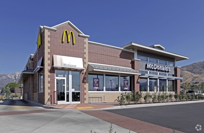
Property Record
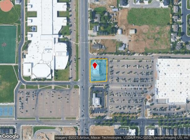
10180 N 4800 W, Pleasant Grove, UT 84062

NEARBY LISTINGS FOR SALE OR LEASE
Property Detail
10180 N 4800 W
Salt Lake City
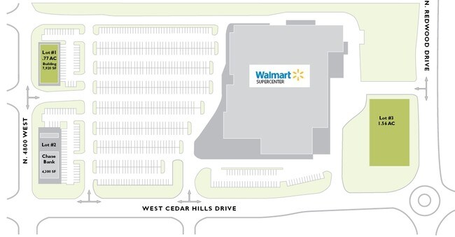
Cedar Hills Retail Sub
Provo-Orem, UT
LOT 1, CEDAR HILLS RETAIL SUBDV. AREA 0.799 AC.
65-268-0001
Utah
Restaurantdrivein
Utah
2024
1
2025
0.80 AC
010220
Utah County
6,305 SF
DEMOGRAPHICS near 10180 N 4800 W
1 Mile
3 Mile
5 Mile
2024 Total Population
9,978
68,361
151,400
2029 Population
11,657
79,674
176,794
Pop Growth 2024-2029
+ 16.83%
+ 16.55%
+ 16.77%
Average Age
35
34
33
2024 Total Households
2,519
17,581
42,116
HH Growth 2024-2029
+ 17.27%
+ 16.96%
+ 17.20%
Median Household Inc
$131,602
$125,649
$107,348
Avg Household Size
3.90
3.90
3.60
2024 Avg HH Vehicles
3.00
3.00
3.00
Median Home Value
$613,186
$639,601
$547,408
Median Year Built
2000
2000
2001
Nearby Places
Map Layers
Map Styles
 Street
 Aerial
- Restaurants
- Banks
- Shops
- Fitness
- Groceries
PUBLIC TRANSPORTATION
COMMUTER RAIL
DRIVE
WALK
Distance
13 min
5.4 mi
DRIVE
WALK
Distance
15 min
8.4 mi
AIRPORT
Provo Municipal
DRIVE
WALK
Distance
Provo Municipal
27 min
17.5 mi
Salt Lake City International
DRIVE
WALK
Distance
Salt Lake City International
46 min
36.4 mi
Nearby Properties
Address
Land Use
TOTAL SIZE
Lot Size
Zoning
Address
Land Use
TOTAL SIZE
Lot Size
Zoning
165,821 SF
12.29 AC
Address
Land Use
TOTAL SIZE
Lot Size
Zoning
409,362 SF
29.53 AC
Address
Land Use
TOTAL SIZE
Lot Size
Zoning
242,954 SF
13.54 AC
Address
Land Use
TOTAL SIZE
Lot Size
Zoning
134,728 SF
13.07 AC
Address
Land Use
TOTAL SIZE
Lot Size
Zoning
70,213 SF
2.14 AC
Address
Land Use
TOTAL SIZE
Lot Size
Zoning
70,678 SF
4.03 AC
Address
Land Use
TOTAL SIZE
Lot Size
Zoning
41,134 SF
2.05 AC
RR5
Address
Land Use
TOTAL SIZE
Lot Size
Zoning
46,203 SF
4.61 AC
Address
Land Use
TOTAL SIZE
Lot Size
Zoning
43,345 SF
4.06 AC
Address
Land Use
TOTAL SIZE
Lot Size
Zoning
81,136 SF
1.85 AC
Address
Land Use
TOTAL SIZE
Lot Size
Zoning
32,740 SF
153.49 AC
Address
Land Use
TOTAL SIZE
Lot Size
Zoning
90,581 SF
3.87 AC
Address
Land Use
TOTAL SIZE
Lot Size
Zoning
33,163 SF
1.64 AC
Address
Land Use
TOTAL SIZE
Lot Size
Zoning
24,070 SF
1.76 AC
Address
Land Use
TOTAL SIZE
Lot Size
Zoning
52,429 SF
2.05 AC
Address
Land Use
TOTAL SIZE
Lot Size
Zoning
47,873 SF
2.24 AC
Address
Land Use
TOTAL SIZE
Lot Size
Zoning
15,094 SF
1.73 AC
Address
Land Use
TOTAL SIZE
Lot Size
Zoning
18,918 SF
1.75 AC
Address
Land Use
TOTAL SIZE
Lot Size
Zoning
44,597 SF
4.26 AC
Address
Land Use
TOTAL SIZE
Lot Size
Zoning
15,319 SF
2.04 AC
Address
Land Use
TOTAL SIZE
Lot Size
Zoning
28,331 SF
5 AC
Address
Land Use
TOTAL SIZE
Lot Size
Zoning
5,954 SF
1.29 AC
Address
Land Use
TOTAL SIZE
Lot Size
Zoning
10,251 SF
1.06 AC
Address
Land Use
TOTAL SIZE
Lot Size
Zoning
14,656 SF
1.73 AC
Address
Land Use
TOTAL SIZE
Lot Size
Zoning
62,013 SF
4.87 AC
Address
Land Use
TOTAL SIZE
Lot Size
Zoning
32,324 SF
2.31 AC
Address
Land Use
TOTAL SIZE
Lot Size
Zoning
21,994 SF
2.04 AC
RR5
Address
Land Use
TOTAL SIZE
Lot Size
Zoning
14,453 SF
1.13 AC
Address
Land Use
TOTAL SIZE
Lot Size
Zoning
15,924 SF
0.98 AC
Address
Land Use
TOTAL SIZE
Lot Size
Zoning
63,359 SF
2.88 AC
The World's #1 Commercial Real Estate Marketplace
Connect with us
© 2025 CoStar Group
The information above has been obtained from sources believed reliable. While we do not doubt its accuracy we have not verified it and make no guarantee, warranty or representation about it. It is your responsibility to independently confirm its accuracy and completeness. Any projections, opinions, assumptions, or estimates used are for example only and do not represent the current or future performance of the property. The value of this transaction to you depends on tax and other factors which should be evaluated by your tax, financial, and legal advisors. You and your advisors should conduct a careful, independent investigation of the property to determine to your satisfaction the suitability of the property for your needs.