Property Record
10185 Custer Rd, Plano, TX 75025

NEARBY LISTINGS FOR SALE OR LEASE
Property Detail
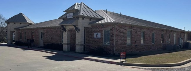
10185 Custer Rd
Dallas-Fort Worth-Arlington, TX
Four Corners Office Building (Cpl)
R-9490-000-3000-1
FOUR CORNERS OFFICE BUILDING, UNIT 200, 37.0 % CMN INT
Commercialcondominium
Collin
X
Texas
48085C0380K
200
2024
0.18 AC
2025
Allen/McKinney
031665
Dallas/Ft Worth
2,044 SF
DEMOGRAPHICS near 10185 Custer Rd
1 Mile
3 Mile
5 Mile
2024 Total Population
14,929
135,732
377,526
2029 Population
18,163
166,006
461,345
Pop Growth 2024-2029
+ 21.66%
+ 22.30%
+ 22.20%
Average Age
36
37
37
2024 Total Households
5,168
46,217
134,613
HH Growth 2024-2029
+ 21.94%
+ 22.57%
+ 22.50%
Median Household Inc
$112,391
$139,463
$117,635
Avg Household Size
2.90
2.90
2.80
2024 Avg HH Vehicles
2.00
2.00
2.00
Median Home Value
$489,747
$465,033
$425,542
Median Year Built
2003
2004
2002
Nearby Places
Map Layers
Map Styles
 Street
 Aerial
- Restaurants
- Banks
- Shops
- Fitness
- Groceries
PUBLIC TRANSPORTATION
AIRPORT
Dallas Love Field
DRIVE
WALK
Distance
Dallas Love Field
36 min
27.1 mi
Dallas-Fort Worth International
DRIVE
WALK
Distance
Dallas-Fort Worth International
33 min
27.9 mi
Freight Ports
Port of Shreveport
DRIVE
WALK
Distance
Port of Shreveport
238 min
214.9 mi
SALE & LEASE HISTORY
LISTING DATE
SALE/LEASE

Mar 03, 2025
For Sale
Jun 13, 2024
For Sale
Nearby Properties
Address
Land Use
TOTAL SIZE
Lot Size
Zoning
Address
Land Use
TOTAL SIZE
Lot Size
Zoning
766,124 SF
62.04 AC
Address
Land Use
TOTAL SIZE
Lot Size
Zoning
649,703 SF
31.92 AC
MF
Address
Land Use
TOTAL SIZE
Lot Size
Zoning
535,339 SF
54.76 AC
Address
Land Use
TOTAL SIZE
Lot Size
Zoning
387,377 SF
64.34 AC
Address
Land Use
TOTAL SIZE
Lot Size
Zoning
511,762 SF
28.81 AC
Address
Land Use
TOTAL SIZE
Lot Size
Zoning
557,288 SF
9.18 AC
Address
Land Use
TOTAL SIZE
Lot Size
Zoning
419,994 SF
19.83 AC
MF-M
Address
Land Use
TOTAL SIZE
Lot Size
Zoning
584,548 SF
33.76 AC
MF
Address
Land Use
TOTAL SIZE
Lot Size
Zoning
493,621 SF
17 AC
APTS
Address
Land Use
TOTAL SIZE
Lot Size
Zoning
537,872 SF
36.28 AC
MF
Address
Land Use
TOTAL SIZE
Lot Size
Zoning
435,382 SF
6.95 AC
MF-E
Address
Land Use
TOTAL SIZE
Lot Size
Zoning
393,074 SF
24.03 AC
MFM
Address
Land Use
TOTAL SIZE
Lot Size
Zoning
294,229 SF
32.11 AC
Address
Land Use
TOTAL SIZE
Lot Size
Zoning
556,741 SF
8.70 AC
MF-R
Address
Land Use
TOTAL SIZE
Lot Size
Zoning
369,702 SF
5.10 AC
Address
Land Use
TOTAL SIZE
Lot Size
Zoning
442,695 SF
24.65 AC
MF-M
Address
Land Use
TOTAL SIZE
Lot Size
Zoning
483,386 SF
4.62 AC
MF-R
Address
Land Use
TOTAL SIZE
Lot Size
Zoning
464,454 SF
11.04 AC
PD
Address
Land Use
TOTAL SIZE
Lot Size
Zoning
471,114 SF
26.05 AC
MF-M
Address
Land Use
TOTAL SIZE
Lot Size
Zoning
397,395 SF
12.25 AC
Address
Land Use
TOTAL SIZE
Lot Size
Zoning
508,028 SF
14.61 AC
Address
Land Use
TOTAL SIZE
Lot Size
Zoning
199,115 SF
1.36 AC
Address
Land Use
TOTAL SIZE
Lot Size
Zoning
357,097 SF
19.68 AC
MF-M
Address
Land Use
TOTAL SIZE
Lot Size
Zoning
390,948 SF
21.95 AC
MF-M
Address
Land Use
TOTAL SIZE
Lot Size
Zoning
334,313 SF
13.61 AC
MF
Address
Land Use
TOTAL SIZE
Lot Size
Zoning
345,998 SF
17.81 AC
MF-M
Address
Land Use
TOTAL SIZE
Lot Size
Zoning
337,425 SF
7.44 AC
MF-E
Address
Land Use
TOTAL SIZE
Lot Size
Zoning
442,463 SF
17.34 AC
Address
Land Use
TOTAL SIZE
Lot Size
Zoning
439,754 SF
13.09 AC
SF
Address
Land Use
TOTAL SIZE
Lot Size
Zoning
443,704 SF
18.87 AC
MFM
The World's #1 Commercial Real Estate Marketplace
Connect with us
© 2026 CoStar Group
The information above has been obtained from sources believed reliable. While we do not doubt its accuracy we have not verified it and make no guarantee, warranty or representation about it. It is your responsibility to independently confirm its accuracy and completeness. Any projections, opinions, assumptions, or estimates used are for example only and do not represent the current or future performance of the property. The value of this transaction to you depends on tax and other factors which should be evaluated by your tax, financial, and legal advisors. You and your advisors should conduct a careful, independent investigation of the property to determine to your satisfaction the suitability of the property for your needs.