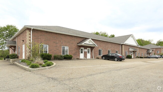
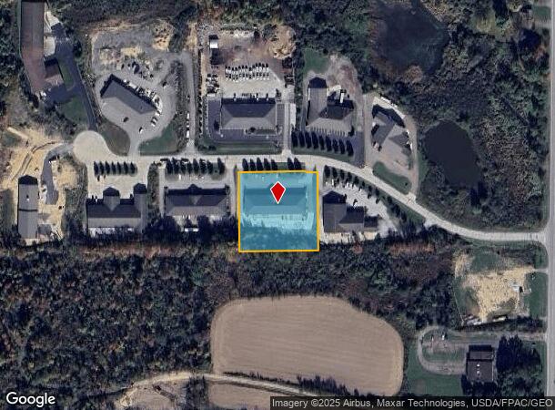
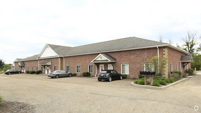
Property Record
10185 Gottschalk Pky, Chagrin Falls, OH 44023
NEARBY LISTINGS FOR SALE OR LEASE
Property Detail
10185 Gottschalk Pky
01-118983
Gottschalk Industrial Park
Warehouse
S/L 2 GOTTSCHALK INDUSTRIAL PARK SUB #1
X
Geauga
39055C0219D
Ohio
2024
1.50 AC
2024
Geauga County
311900
Cleveland
11,716 SF
Cleveland-Elyria, OH
DEMOGRAPHICS near 10185 Gottschalk Pky
1 Mile
3 Mile
5 Mile
2024 Total Population
1,263
8,554
25,540
2029 Population
1,271
8,569
25,608
Pop Growth 2024-2029
+ 0.63%
+ 0.18%
+ 0.27%
Average Age
47
45
45
2024 Total Households
503
3,275
9,421
HH Growth 2024-2029
+ 0.60%
+ 0.09%
+ 0.18%
Median Household Inc
$112,068
$121,668
$122,453
Avg Household Size
2.50
2.60
2.60
2024 Avg HH Vehicles
3.00
2.00
2.00
Median Home Value
$356,938
$342,597
$350,393
Median Year Built
1992
1982
1980
Nearby Places
Map Layers
Map Styles
 Street
 Aerial
- Restaurants
- Banks
- Shops
- Fitness
- Groceries
PUBLIC TRANSPORTATION
AIRPORT
Cleveland-Hopkins International
DRIVE
WALK
Distance
Cleveland-Hopkins International
50 min
33.8 mi
SALE & LEASE HISTORY
LISTING DATE
SALE/LEASE

Sep 25, 2016
For Lease
Nearby Properties
Address
Land Use
TOTAL SIZE
Lot Size
Zoning
Address
Land Use
TOTAL SIZE
Lot Size
Zoning
227,389 SF
27.75 AC
R5A
Address
Land Use
TOTAL SIZE
Lot Size
Zoning
79,668 SF
14 AC
R5A
Address
Land Use
TOTAL SIZE
Lot Size
Zoning
18,614 SF
45.79 AC
R3A
Address
Land Use
TOTAL SIZE
Lot Size
Zoning
100,601 SF
40.70 AC
R5A
Address
Land Use
TOTAL SIZE
Lot Size
Zoning
30,295 SF
7.12 AC
R5A
Address
Land Use
TOTAL SIZE
Lot Size
Zoning
20,820 SF
7.19 AC
B1
Address
Land Use
TOTAL SIZE
Lot Size
Zoning
4,814 SF
63.75 AC
R1
Address
Land Use
TOTAL SIZE
Lot Size
Zoning
71,570 SF
11.04 AC
I1
Address
Land Use
TOTAL SIZE
Lot Size
Zoning
62,290 SF
7.38 AC
I1
Address
Land Use
TOTAL SIZE
Lot Size
Zoning
81,899 SF
2.23 AC
I1
Address
Land Use
TOTAL SIZE
Lot Size
Zoning
1,897 SF
44.70 AC
R5A
Address
Land Use
TOTAL SIZE
Lot Size
Zoning
15,328 SF
54.91 AC
R1
Address
Land Use
TOTAL SIZE
Lot Size
Zoning
34,988 SF
12.36 AC
R5A
Address
Land Use
TOTAL SIZE
Lot Size
Zoning
4,887 SF
74.27 AC
R5A
Address
Land Use
TOTAL SIZE
Lot Size
Zoning
57,340 SF
17 AC
R5A
Address
Land Use
TOTAL SIZE
Lot Size
Zoning
2,472 SF
74.27 AC
R1
Address
Land Use
TOTAL SIZE
Lot Size
Zoning
7,173 SF
21.58 AC
R1
Address
Land Use
TOTAL SIZE
Lot Size
Zoning
250 AC
OS1
Address
Land Use
TOTAL SIZE
Lot Size
Zoning
5,179 SF
29.19 AC
R5A
Address
Land Use
TOTAL SIZE
Lot Size
Zoning
62,353 SF
21.10 AC
I1
Address
Land Use
TOTAL SIZE
Lot Size
Zoning
1,942 SF
133.50 AC
R5A
Address
Land Use
TOTAL SIZE
Lot Size
Zoning
26,630 SF
3.85 AC
I1
Address
Land Use
TOTAL SIZE
Lot Size
Zoning
48,796 SF
9.02 AC
B1
Address
Land Use
TOTAL SIZE
Lot Size
Zoning
31,360 SF
3.05 AC
I1
Address
Land Use
TOTAL SIZE
Lot Size
Zoning
15,212 SF
15.43 AC
APP
Address
Land Use
TOTAL SIZE
Lot Size
Zoning
38,388 SF
4.28 AC
I1
Address
Land Use
TOTAL SIZE
Lot Size
Zoning
3,113 SF
90.63 AC
R1
Address
Land Use
TOTAL SIZE
Lot Size
Zoning
23,756 SF
72.03 AC
R3A
Address
Land Use
TOTAL SIZE
Lot Size
Zoning
13.47 AC
R1
Address
Land Use
TOTAL SIZE
Lot Size
Zoning
4,116 SF
29.21 AC
R3A
The World's #1 Commercial Real Estate Marketplace
Connect with us
© 2025 CoStar Group
The information above has been obtained from sources believed reliable. While we do not doubt its accuracy we have not verified it and make no guarantee, warranty or representation about it. It is your responsibility to independently confirm its accuracy and completeness. Any projections, opinions, assumptions, or estimates used are for example only and do not represent the current or future performance of the property. The value of this transaction to you depends on tax and other factors which should be evaluated by your tax, financial, and legal advisors. You and your advisors should conduct a careful, independent investigation of the property to determine to your satisfaction the suitability of the property for your needs.