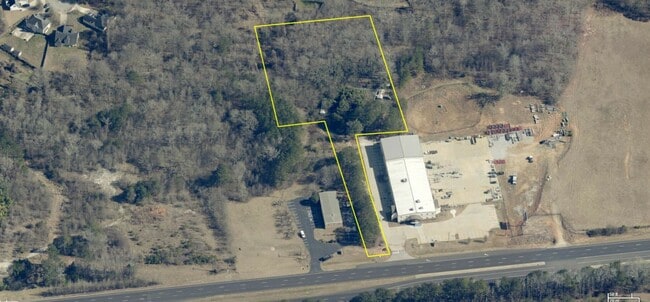
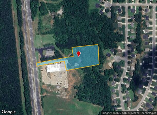
Property Record
1019 Highway 19 41, Hampton, GA 30228
This Property Is For Sale
NEARBY LISTINGS FOR SALE OR LEASE
Property Detail
1019 Highway 19 41
Atlanta-Sandy Springs-Roswell, GA
Simpson Mill Plantation Ph A
0008-01-019-000
Henry
Modularprefabricatedhomes
Georgia
A
2 AC
13151C0143D
South Clayton/Henry Cnty
1,848 SF
Atlanta
DEMOGRAPHICS near 1019 Highway 19 41
1 Mile
3 Mile
5 Mile
2024 Total Population
3,434
21,882
57,774
2029 Population
4,066
24,803
62,791
Pop Growth 2024-2029
+ 18.40%
+ 13.35%
+ 8.68%
Average Age
35
37
37
2024 Total Households
1,116
7,346
18,933
HH Growth 2024-2029
+ 18.91%
+ 13.61%
+ 8.95%
Median Household Inc
$52,544
$72,417
$76,369
Avg Household Size
3.10
3.00
2.90
2024 Avg HH Vehicles
2.00
2.00
2.00
Median Home Value
$276,342
$302,492
$302,790
Median Year Built
2001
2003
2002
Nearby Places
- Restaurants
- Banks
- Shops
- Fitness
- Groceries
PUBLIC TRANSPORTATION
AIRPORT
Hartsfield - Jackson Atlanta International
DRIVE
WALK
Distance
Hartsfield - Jackson Atlanta International
32 min
20.1 mi
Freight Ports
Georgia Ports - Savannah
DRIVE
WALK
Distance
Georgia Ports - Savannah
258 min
229.2 mi
Nearby Properties
Address
Land Use
TOTAL SIZE
Lot Size
Zoning
Address
Land Use
TOTAL SIZE
Lot Size
Zoning
269,130 SF
15.78 AC
C
Address
Land Use
TOTAL SIZE
Lot Size
Zoning
1,424,654 SF
172.86 AC
Address
Land Use
TOTAL SIZE
Lot Size
Zoning
39,373 SF
587.19 AC
M1
Address
Land Use
TOTAL SIZE
Lot Size
Zoning
640,693 SF
691.83 AC
PD
Address
Land Use
TOTAL SIZE
Lot Size
Zoning
224 SF
20 AC
C
Address
Land Use
TOTAL SIZE
Lot Size
Zoning
8.44 AC
C
Address
Land Use
TOTAL SIZE
Lot Size
Zoning
42,762 SF
6 AC
C
Address
Land Use
TOTAL SIZE
Lot Size
Zoning
147,861 SF
36.79 AC
M1
Address
Land Use
TOTAL SIZE
Lot Size
Zoning
96.63 AC
PD
Address
Land Use
TOTAL SIZE
Lot Size
Zoning
26,297 SF
77 AC
AG
Address
Land Use
TOTAL SIZE
Lot Size
Zoning
9.19 AC
C
Address
Land Use
TOTAL SIZE
Lot Size
Zoning
402.93 AC
Address
Land Use
TOTAL SIZE
Lot Size
Zoning
1,826 SF
169.71 AC
C
Address
Land Use
TOTAL SIZE
Lot Size
Zoning
41,568 SF
29.31 AC
M2
Address
Land Use
TOTAL SIZE
Lot Size
Zoning
1,404 SF
62.12 AC
RMH
Address
Land Use
TOTAL SIZE
Lot Size
Zoning
80,166 SF
95.23 AC
HI
Address
Land Use
TOTAL SIZE
Lot Size
Zoning
35 SF
2.90 AC
C
Address
Land Use
TOTAL SIZE
Lot Size
Zoning
24,540 SF
26 AC
C1
Address
Land Use
TOTAL SIZE
Lot Size
Zoning
26.60 AC
C
Address
Land Use
TOTAL SIZE
Lot Size
Zoning
16,958 SF
2.27 AC
C
Address
Land Use
TOTAL SIZE
Lot Size
Zoning
371,928 SF
10.16 AC
M1
Address
Land Use
TOTAL SIZE
Lot Size
Zoning
87,276 SF
5 AC
M1
Address
Land Use
TOTAL SIZE
Lot Size
Zoning
39,681 SF
6.19 AC
C2
Address
Land Use
TOTAL SIZE
Lot Size
Zoning
183,000 SF
6.40 AC
M2
Address
Land Use
TOTAL SIZE
Lot Size
Zoning
68,010 SF
8 AC
M1
The World's #1 Commercial Real Estate Marketplace
Connect with us
© 2025 CoStar Group
The information above has been obtained from sources believed reliable. While we do not doubt its accuracy we have not verified it and make no guarantee, warranty or representation about it. It is your responsibility to independently confirm its accuracy and completeness. Any projections, opinions, assumptions, or estimates used are for example only and do not represent the current or future performance of the property. The value of this transaction to you depends on tax and other factors which should be evaluated by your tax, financial, and legal advisors. You and your advisors should conduct a careful, independent investigation of the property to determine to your satisfaction the suitability of the property for your needs.