Property Record
10195 Riverford Rd, Lakeside, CA 92040


Save to a Folder
{{folder.Name}}
{{folder.ListingIds.length}} Properties
{{folder.ListingIds.length}} Property
Create a New Folder
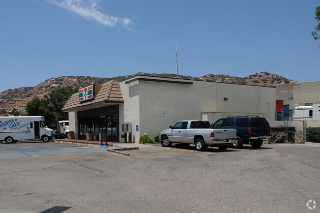
Property Detail
10195 Riverford Rd
379-141-28
PAR 2 TR PM14259
Servicestation
San Diego
C36
California
B and X Area of moderate flood hazard, usually the area between the limits of the 100-year and 500-year floods.
0.53 AC
2025
Santee
2026
San Diego
016901
San Diego-Chula Vista-Carlsbad, CA
2,880 SF
NEARBY LISTINGS FOR SALE OR LEASE
DEMOGRAPHICS near 10195 Riverford Rd
1 mile
3 mile
5 mile
2025 Total Population
8,717
83,636
201,445
2030 Population
8,640
83,606
201,108
Pop Growth 2025-2030
(0.88%)
(0.04%)
(0.17%)
Average Age
40
40
39
2025 Total Households
3,040
28,703
68,962
HH Growth 2025-2030
(1.02%)
(0.16%)
(0.33%)
Median Household Inc
$121,946
$106,506
$90,301
Avg Household Size
2.80
2.80
2.80
2025 Avg HH Vehicles
2.00
2.00
2.00
Median Home Value
$747,161
$694,315
$694,011
Median Year Built
1979
1978
1976
Nearby Places
Map Layers
Map Styles
 Street
 Aerial
Layers
 Traffic
 Biking
Places
Listings with unknown addresses are not visible on the map
- Restaurants
- Banks
- Shops
- Fitness
- Groceries
PUBLIC TRANSPORTATION
AIRPORT
San Diego International
Drive
Walk
Distance
San Diego International
28 min
21.1 mi
Nearby Properties
Address
Land Use
TOTAL SIZE
Lot Size
Zoning
Address
Land Use
TOTAL SIZE
Lot Size
Zoning
6.82 AC
TC
Address
Land Use
TOTAL SIZE
Lot Size
Zoning
9,999 SF
9.38 AC
RU
Address
Land Use
TOTAL SIZE
Lot Size
Zoning
9,999 SF
5.77 AC
RU
Address
Land Use
TOTAL SIZE
Lot Size
Zoning
5,848 SF
5.03 AC
GC
Address
Land Use
TOTAL SIZE
Lot Size
Zoning
9,999 SF
10.23 AC
R22
Address
Land Use
TOTAL SIZE
Lot Size
Zoning
9,999 SF
5.45 AC
R14
Address
Land Use
TOTAL SIZE
Lot Size
Zoning
9,999 SF
3.80 AC
NC/R14
Address
Land Use
TOTAL SIZE
Lot Size
Zoning
9,999 SF
4.75 AC
C-6
Address
Land Use
TOTAL SIZE
Lot Size
Zoning
3.33 AC
R22
Address
Land Use
TOTAL SIZE
Lot Size
Zoning
9,999 SF
4.80 AC
RU
Address
Land Use
TOTAL SIZE
Lot Size
Zoning
10.79 AC
TC
Address
Land Use
TOTAL SIZE
Lot Size
Zoning
9,662 SF
8.21 AC
S88
Address
Land Use
TOTAL SIZE
Lot Size
Zoning
4,882 SF
3.45 AC
RU
Address
Land Use
TOTAL SIZE
Lot Size
Zoning
9,999 SF
4.93 AC
C36
Address
Land Use
TOTAL SIZE
Lot Size
Zoning
9,999 SF
4.61 AC
R7
Address
Land Use
TOTAL SIZE
Lot Size
Zoning
9,999 SF
8.72 AC
R14
Address
Land Use
TOTAL SIZE
Lot Size
Zoning
6,977 SF
8.24 AC
TC
Address
Land Use
TOTAL SIZE
Lot Size
Zoning
22.15 AC
TC
Address
Land Use
TOTAL SIZE
Lot Size
Zoning
9,999 SF
10.50 AC
TC
Address
Land Use
TOTAL SIZE
Lot Size
Zoning
7,704 SF
3.74 AC
RU
Address
Land Use
TOTAL SIZE
Lot Size
Zoning
9,999 SF
5.16 AC
IL/GC
Address
Land Use
TOTAL SIZE
Lot Size
Zoning
5,498 SF
6.77 AC
TC
Address
Land Use
TOTAL SIZE
Lot Size
Zoning
9,999 SF
9.93 AC
S88
Address
Land Use
TOTAL SIZE
Lot Size
Zoning
5,170 SF
5.11 AC
GC
Address
Land Use
TOTAL SIZE
Lot Size
Zoning
1,578 SF
4.95 AC
R14
Address
Land Use
TOTAL SIZE
Lot Size
Zoning
9,999 SF
8.04 AC
TC
Address
Land Use
TOTAL SIZE
Lot Size
Zoning
9,999 SF
14 AC
TC
Address
Land Use
TOTAL SIZE
Lot Size
Zoning
7,840 SF
5.59 AC
R7
Address
Land Use
TOTAL SIZE
Lot Size
Zoning
35.63 AC
S88
Address
Land Use
TOTAL SIZE
Lot Size
Zoning
405 SF
5.44 AC
IL
The World's #1 Commercial Real Estate Marketplace
Connect with us
© 2026 CoStar Group
The information above has been obtained from sources believed reliable. While we do not doubt its accuracy we have not verified it and make no guarantee, warranty or representation about it. It is your responsibility to independently confirm its accuracy and completeness. Any projections, opinions, assumptions, or estimates used are for example only and do not represent the current or future performance of the property. The value of this transaction to you depends on tax and other factors which should be evaluated by your tax, financial, and legal advisors. You and your advisors should conduct a careful, independent investigation of the property to determine to your satisfaction the suitability of the property for your needs.