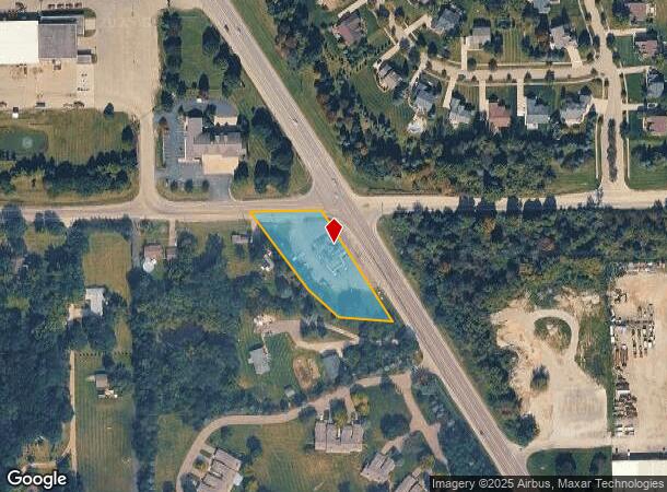
Property Record
10197 Dixie Hwy, Davisburg, MI 48350

NEARBY LISTINGS FOR SALE OR LEASE
Property Detail
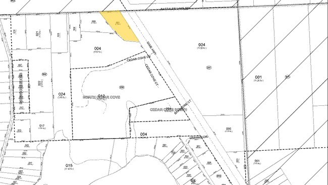
10197 Dixie Hwy
07-10-226-001
T4N, R8E, SEC 10 PART OF NE 1/4 BEG AT PT DIST S 89-51-00 W 1115.34 FT FROM NE SEC COR, TH S 31-12-00 E 347.44 FT, TH N 83-14-00 W 141.26 FT, TH N 47-18-00 W 109.99 FT, TH N 35-50-00 W 253.36 FT, TH N 89-51-00 E 190.03 FT TO BEG 1.12 A U136A
Bartavern
Oakland
X
Michigan
26125C0190F
1.12 AC
2024
St Clair & Lapeer Counties
2024
Detroit
126400
Detroit-Warren-Dearborn, MI
2,538 SF
DEMOGRAPHICS near 10197 Dixie Hwy
1 Mile
3 Mile
5 Mile
2024 Total Population
2,150
12,217
30,316
2029 Population
2,131
12,134
30,199
Pop Growth 2024-2029
(0.88%)
(0.68%)
(0.39%)
Average Age
43
42
43
2024 Total Households
825
4,545
11,155
HH Growth 2024-2029
(1.09%)
(0.75%)
(0.39%)
Median Household Inc
$102,500
$101,713
$109,624
Avg Household Size
2.60
2.60
2.70
2024 Avg HH Vehicles
2.00
2.00
2.00
Median Home Value
$350,826
$358,654
$350,447
Median Year Built
1983
1989
1984
Nearby Places
Map Layers
Map Styles
 Street
 Aerial
- Restaurants
- Banks
- Shops
- Fitness
- Groceries
PUBLIC TRANSPORTATION
AIRPORT
Bishop International
DRIVE
WALK
Distance
Bishop International
36 min
22.5 mi
Freight Ports
Port of Toledo
DRIVE
WALK
Distance
Port of Toledo
116 min
89.8 mi
Nearby Properties
Address
Land Use
TOTAL SIZE
Lot Size
Zoning
Address
Land Use
TOTAL SIZE
Lot Size
Zoning
34,111 SF
20.14 AC
Address
Land Use
TOTAL SIZE
Lot Size
Zoning
6,981 SF
88.04 AC
Address
Land Use
TOTAL SIZE
Lot Size
Zoning
8,617 SF
71.35 AC
MM
Address
Land Use
TOTAL SIZE
Lot Size
Zoning
261,633 SF
1,321.20 AC
C2GEN
Address
Land Use
TOTAL SIZE
Lot Size
Zoning
26,221 SF
15.76 AC
C2
Address
Land Use
TOTAL SIZE
Lot Size
Zoning
44,258 SF
8.86 AC
C2GEN
Address
Land Use
TOTAL SIZE
Lot Size
Zoning
59,491 SF
6.94 AC
C2GEN
Address
Land Use
TOTAL SIZE
Lot Size
Zoning
26,331 SF
6 AC
C2GEN
Address
Land Use
TOTAL SIZE
Lot Size
Zoning
74,592 SF
8.05 AC
RMMULT
Address
Land Use
TOTAL SIZE
Lot Size
Zoning
57,600 SF
15.72 AC
M1LITE
Address
Land Use
TOTAL SIZE
Lot Size
Zoning
77,403 SF
4.58 AC
M1LITE
Address
Land Use
TOTAL SIZE
Lot Size
Zoning
14,218 SF
16.94 AC
Address
Land Use
TOTAL SIZE
Lot Size
Zoning
64,195 SF
5.01 AC
M1LITE
Address
Land Use
TOTAL SIZE
Lot Size
Zoning
20,135 SF
4.54 AC
C2
Address
Land Use
TOTAL SIZE
Lot Size
Zoning
13,667 SF
2.33 AC
R1
Address
Land Use
TOTAL SIZE
Lot Size
Zoning
24.97 AC
Address
Land Use
TOTAL SIZE
Lot Size
Zoning
19.27 AC
C2
Address
Land Use
TOTAL SIZE
Lot Size
Zoning
4,068 SF
1.44 AC
C2
Address
Land Use
TOTAL SIZE
Lot Size
Zoning
11,526 SF
6.45 AC
BI
Address
Land Use
TOTAL SIZE
Lot Size
Zoning
31,378 SF
2.42 AC
M1LITE
Address
Land Use
TOTAL SIZE
Lot Size
Zoning
6,268 SF
4.33 AC
OS
Address
Land Use
TOTAL SIZE
Lot Size
Zoning
26,701 SF
2.78 AC
M1LITE
Address
Land Use
TOTAL SIZE
Lot Size
Zoning
4,288 SF
126.64 AC
IV
Address
Land Use
TOTAL SIZE
Lot Size
Zoning
4,182 SF
1.70 AC
C2GEN
Address
Land Use
TOTAL SIZE
Lot Size
Zoning
25,060 SF
3.85 AC
RMMULT
Address
Land Use
TOTAL SIZE
Lot Size
Zoning
68.92 AC
FI
Address
Land Use
TOTAL SIZE
Lot Size
Zoning
8,534 SF
3 AC
C2GEN
Address
Land Use
TOTAL SIZE
Lot Size
Zoning
19,080 SF
40.01 AC
M1LITE
Address
Land Use
TOTAL SIZE
Lot Size
Zoning
35,810 SF
2.01 AC
M1
Address
Land Use
TOTAL SIZE
Lot Size
Zoning
15,475 SF
3.50 AC
M1LITE
The World's #1 Commercial Real Estate Marketplace
Connect with us
© 2025 CoStar Group
The information above has been obtained from sources believed reliable. While we do not doubt its accuracy we have not verified it and make no guarantee, warranty or representation about it. It is your responsibility to independently confirm its accuracy and completeness. Any projections, opinions, assumptions, or estimates used are for example only and do not represent the current or future performance of the property. The value of this transaction to you depends on tax and other factors which should be evaluated by your tax, financial, and legal advisors. You and your advisors should conduct a careful, independent investigation of the property to determine to your satisfaction the suitability of the property for your needs.