Property Record
101St St, Kenosha, WI 53142
NEARBY LISTINGS FOR SALE OR LEASE
-
-
View all Kenosha listings for lease on LoopNet.com
Property Detail
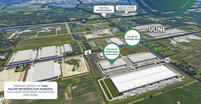
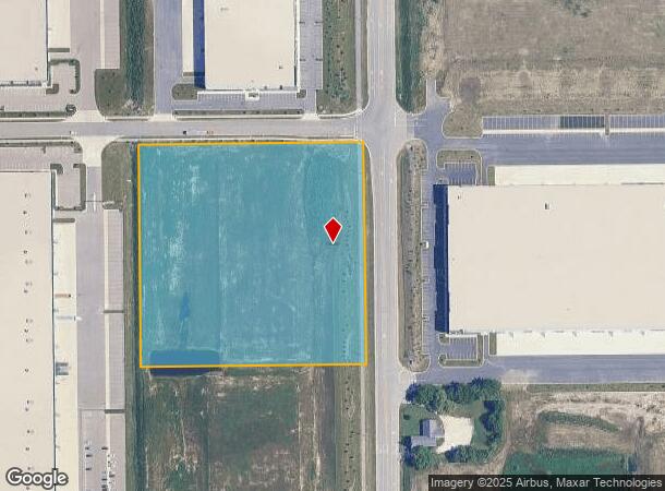
101St St
Chicago-Naperville-Elgin, IL-IN-WI
PT SE 1/4SEC 23 T 1 R 21 LOT 5 BRISTOL BUSINESS PARK SUB PLAT #8068 DOC#1884894 EXC ROW DOC#1884893 8.048 AC (2021 COMB/SPLIT
37-4-121-234-0105
Kenosha
Commercialacreage
Wisconsin
X
5
55059C0166D
8.05 AC
2024
Kenosha East
2024
Chicago
002500
DEMOGRAPHICS near 101St St
1 Mile
3 Mile
5 Mile
2024 Total Population
118
2,851
25,485
2029 Population
123
2,944
25,732
Pop Growth 2024-2029
+ 4.24%
+ 3.26%
+ 0.97%
Average Age
40
41
40
2024 Total Households
45
1,190
9,737
HH Growth 2024-2029
+ 2.22%
+ 3.11%
+ 1.04%
Median Household Inc
$124,999
$87,909
$96,682
Avg Household Size
2.60
2.30
2.60
2024 Avg HH Vehicles
2.00
2.00
2.00
Median Home Value
$455,555
$352,272
$301,148
Median Year Built
2005
2000
1999
Nearby Places
Map Layers
Map Styles
 Street
 Aerial
- Restaurants
- Banks
- Shops
- Fitness
- Groceries
PUBLIC TRANSPORTATION
COMMUTER RAIL
Antioch Station (North Central Service - Northeast Illinois Regional Commuter Railroad (Metra))
DRIVE
WALK
Distance
Antioch Station (North Central Service - Northeast Illinois Regional Commuter Railroad (Metra))
17 min
8.7 mi
AIRPORT
General Mitchell International
DRIVE
WALK
Distance
General Mitchell International
39 min
32.3 mi
Freight Ports
Port Milwaukee
DRIVE
WALK
Distance
Port Milwaukee
44 min
36.2 mi
SALE & LEASE HISTORY
LISTING DATE
SALE/LEASE

Oct 25, 2024
For Lease
Nearby Properties
Address
Land Use
TOTAL SIZE
Lot Size
Zoning
Address
Land Use
TOTAL SIZE
Lot Size
Zoning
1,083,094 SF
230.85 AC
Address
Land Use
TOTAL SIZE
Lot Size
Zoning
159,194 SF
136.60 AC
Address
Land Use
TOTAL SIZE
Lot Size
Zoning
75,755 SF
19.27 AC
Address
Land Use
TOTAL SIZE
Lot Size
Zoning
51,119 SF
63.71 AC
Address
Land Use
TOTAL SIZE
Lot Size
Zoning
12.53 AC
Address
Land Use
TOTAL SIZE
Lot Size
Zoning
108,727 SF
67.52 AC
Address
Land Use
TOTAL SIZE
Lot Size
Zoning
590,185 SF
46.90 AC
Address
Land Use
TOTAL SIZE
Lot Size
Zoning
38,201 SF
16 AC
Address
Land Use
TOTAL SIZE
Lot Size
Zoning
12,794 SF
16.75 AC
Address
Land Use
TOTAL SIZE
Lot Size
Zoning
77,776 SF
36.16 AC
Address
Land Use
TOTAL SIZE
Lot Size
Zoning
27.77 AC
Address
Land Use
TOTAL SIZE
Lot Size
Zoning
418,036 SF
25.33 AC
Address
Land Use
TOTAL SIZE
Lot Size
Zoning
447,200 SF
23.50 AC
Address
Land Use
TOTAL SIZE
Lot Size
Zoning
396,508 SF
21.72 AC
Address
Land Use
TOTAL SIZE
Lot Size
Zoning
21.62 AC
Address
Land Use
TOTAL SIZE
Lot Size
Zoning
314,505 SF
19.30 AC
Address
Land Use
TOTAL SIZE
Lot Size
Zoning
200,637 SF
12.01 AC
Address
Land Use
TOTAL SIZE
Lot Size
Zoning
105,600 SF
15.75 AC
Address
Land Use
TOTAL SIZE
Lot Size
Zoning
69,568 SF
37.52 AC
Address
Land Use
TOTAL SIZE
Lot Size
Zoning
157,656 SF
10.92 AC
Address
Land Use
TOTAL SIZE
Lot Size
Zoning
11.13 AC
Address
Land Use
TOTAL SIZE
Lot Size
Zoning
20,950 SF
11.11 AC
Address
Land Use
TOTAL SIZE
Lot Size
Zoning
73,272 SF
5.60 AC
Address
Land Use
TOTAL SIZE
Lot Size
Zoning
71,079 SF
6.32 AC
Address
Land Use
TOTAL SIZE
Lot Size
Zoning
79,068 SF
9.24 AC
Address
Land Use
TOTAL SIZE
Lot Size
Zoning
10.68 AC
Address
Land Use
TOTAL SIZE
Lot Size
Zoning
61,288 SF
4.27 AC
Address
Land Use
TOTAL SIZE
Lot Size
Zoning
43,134 SF
2.88 AC
Address
Land Use
TOTAL SIZE
Lot Size
Zoning
100,120 SF
8.19 AC
Address
Land Use
TOTAL SIZE
Lot Size
Zoning
33,239 SF
5.42 AC
The World's #1 Commercial Real Estate Marketplace
Connect with us
© 2025 CoStar Group
The information above has been obtained from sources believed reliable. While we do not doubt its accuracy we have not verified it and make no guarantee, warranty or representation about it. It is your responsibility to independently confirm its accuracy and completeness. Any projections, opinions, assumptions, or estimates used are for example only and do not represent the current or future performance of the property. The value of this transaction to you depends on tax and other factors which should be evaluated by your tax, financial, and legal advisors. You and your advisors should conduct a careful, independent investigation of the property to determine to your satisfaction the suitability of the property for your needs.