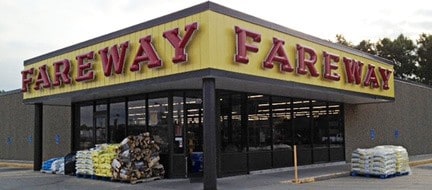
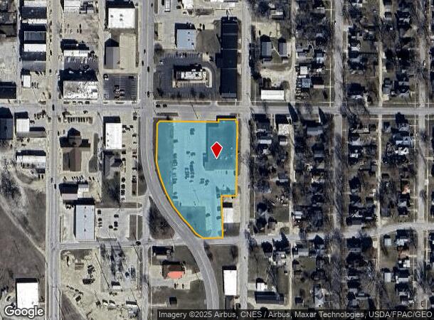
Property Record
102 2Nd St Se, Oelwein, IA 50662
NEARBY LISTINGS FOR SALE OR LEASE
-
-
View all Oelwein listings for sale on LoopNet.com
Property Detail
102 2Nd St Se
18-21-452-002
BLK 4 EX TO D.O.T., BLK 9 EX LOTS 1,2,3, ORIG. OELWEIN & 10' STRIP ADJ ON N & 5' STRIP ADJ ON E & FORMER RY R.O.W. BET BLK 4
Supermarket
Fayette
X
Iowa
19065C0416F
1-3
2025
3.31 AC
2025
Iowa Northeast Area
080500
Other Market Areas
21,561 SF
DEMOGRAPHICS near 102 2Nd St Se
1 mile
3 mile
5 mile
2024 Total Population
5,813
6,659
7,980
2029 Population
5,771
6,609
7,957
Pop Growth 2024-2029
(0.72%)
(0.75%)
(0.29%)
Average Age
43
43
42
2024 Total Households
2,502
2,873
3,387
HH Growth 2024-2029
(0.76%)
(0.80%)
(0.38%)
Median Household Inc
$38,890
$38,717
$42,457
Avg Household Size
2.20
2.20
2.20
2024 Avg HH Vehicles
2.00
2.00
2.00
Median Home Value
$98,370
$97,663
$102,164
Median Year Built
1954
1954
1957
Nearby Places
Map Layers
Map Styles
 Street
 Aerial
Transit
 Traffic
 Biking
Places
Listings with unknown addresses are not visible on the map
- Restaurants
- Banks
- Shops
- Fitness
- Groceries
Nearby Properties
Address
Land Use
TOTAL SIZE
Lot Size
Zoning
Address
Land Use
TOTAL SIZE
Lot Size
Zoning
140 SF
28.27 AC
Address
Land Use
TOTAL SIZE
Lot Size
Zoning
2.44 AC
Address
Land Use
TOTAL SIZE
Lot Size
Zoning
15,145 SF
1.80 AC
Address
Land Use
TOTAL SIZE
Lot Size
Zoning
3,600 SF
27.95 AC
Address
Land Use
TOTAL SIZE
Lot Size
Zoning
13,586 SF
10 AC
Address
Land Use
TOTAL SIZE
Lot Size
Zoning
26,901 SF
2.57 AC
Address
Land Use
TOTAL SIZE
Lot Size
Zoning
2,600 SF
4.77 AC
Address
Land Use
TOTAL SIZE
Lot Size
Zoning
9,232 SF
4.10 AC
Address
Land Use
TOTAL SIZE
Lot Size
Zoning
2,408 SF
5.74 AC
Address
Land Use
TOTAL SIZE
Lot Size
Zoning
58,764 SF
9.87 AC
Address
Land Use
TOTAL SIZE
Lot Size
Zoning
3,280 SF
11.67 AC
Address
Land Use
TOTAL SIZE
Lot Size
Zoning
27,840 SF
4 AC
Address
Land Use
TOTAL SIZE
Lot Size
Zoning
13,004 SF
3.35 AC
Address
Land Use
TOTAL SIZE
Lot Size
Zoning
12,052 SF
5.41 AC
Address
Land Use
TOTAL SIZE
Lot Size
Zoning
19,121 SF
4.07 AC
Address
Land Use
TOTAL SIZE
Lot Size
Zoning
1,800 SF
6.05 AC
Address
Land Use
TOTAL SIZE
Lot Size
Zoning
10,941 SF
1.05 AC
Address
Land Use
TOTAL SIZE
Lot Size
Zoning
59,910 SF
9.64 AC
Address
Land Use
TOTAL SIZE
Lot Size
Zoning
4,340 SF
16.91 AC
Address
Land Use
TOTAL SIZE
Lot Size
Zoning
11,837 SF
5.26 AC
Address
Land Use
TOTAL SIZE
Lot Size
Zoning
8,939 SF
0.96 AC
Address
Land Use
TOTAL SIZE
Lot Size
Zoning
9,988 SF
2.87 AC
Address
Land Use
TOTAL SIZE
Lot Size
Zoning
15,892 SF
1.47 AC
Address
Land Use
TOTAL SIZE
Lot Size
Zoning
49,925 SF
6.80 AC
Address
Land Use
TOTAL SIZE
Lot Size
Zoning
684 SF
8.09 AC
Address
Land Use
TOTAL SIZE
Lot Size
Zoning
6,906 SF
0.84 AC
Address
Land Use
TOTAL SIZE
Lot Size
Zoning
40,480 SF
4.21 AC
Address
Land Use
TOTAL SIZE
Lot Size
Zoning
15,384 SF
2.62 AC
Address
Land Use
TOTAL SIZE
Lot Size
Zoning
2,324 SF
151.46 AC
The World's #1 Commercial Real Estate Marketplace
Connect with us
© 2026 CoStar Group
The information above has been obtained from sources believed reliable. While we do not doubt its accuracy we have not verified it and make no guarantee, warranty or representation about it. It is your responsibility to independently confirm its accuracy and completeness. Any projections, opinions, assumptions, or estimates used are for example only and do not represent the current or future performance of the property. The value of this transaction to you depends on tax and other factors which should be evaluated by your tax, financial, and legal advisors. You and your advisors should conduct a careful, independent investigation of the property to determine to your satisfaction the suitability of the property for your needs.