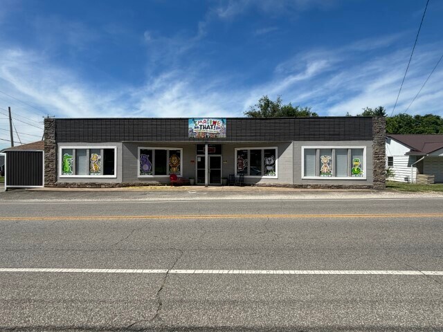
Property Record
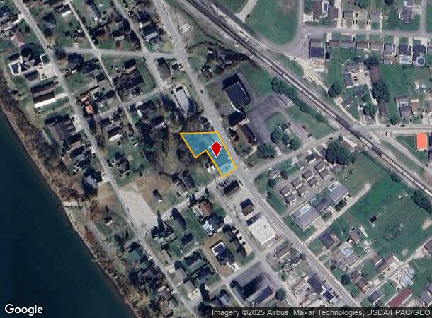
102 4Th St W, South Point, OH 45680
NEARBY LISTINGS FOR SALE OR LEASE
Property Detail
102 4Th St W
07-030-1600-000
W P Davidsons Second Addition
Commercialnec
17-01-05 W.F. DAVIDSON GRAVE- YARD NE PT. 0000.51A
AE
Lawrence
54099C0015D
Ohio
0
0.51 AC
2024
Lawrence County
051101
Huntington/Ashland
6,621 SF
Huntington-Ashland, WV-KY-OH
DEMOGRAPHICS near 102 4Th St W
1 Mile
3 Mile
5 Mile
2024 Total Population
4,044
17,964
45,206
2029 Population
3,923
17,510
44,299
Pop Growth 2024-2029
(2.99%)
(2.53%)
(2.01%)
Average Age
42
42
42
2024 Total Households
1,643
7,414
18,958
HH Growth 2024-2029
(2.98%)
(2.43%)
(1.90%)
Median Household Inc
$53,500
$45,194
$49,820
Avg Household Size
2.30
2.30
2.30
2024 Avg HH Vehicles
2.00
2.00
2.00
Median Home Value
$130,290
$115,826
$122,282
Median Year Built
1971
1970
1966
Nearby Places
Map Layers
Map Styles
 Street
 Aerial
- Restaurants
- Banks
- Shops
- Fitness
- Groceries
PUBLIC TRANSPORTATION
COMMUTER RAIL
Ashland Amtrak Station (Cardinal - Amtrak)
DRIVE
WALK
Distance
Ashland Amtrak Station (Cardinal - Amtrak)
11 min
7.7 mi
AIRPORT
Tri-State/Milton J Ferguson Field
DRIVE
WALK
Distance
Tri-State/Milton J Ferguson Field
25 min
16.7 mi
Freight Ports
Port of Toledo
DRIVE
WALK
Distance
Port of Toledo
341 min
263.7 mi
SALE & LEASE HISTORY
LISTING DATE
SALE/LEASE

May 03, 2017
For Sale
Jul 02, 2024
For Sale
Feb 21, 2018
For Sale
Aug 03, 2017
For Sale
Nearby Properties
Address
Land Use
TOTAL SIZE
Lot Size
Zoning
Address
Land Use
TOTAL SIZE
Lot Size
Zoning
2.83 AC
Address
Land Use
TOTAL SIZE
Lot Size
Zoning
123,920 SF
6.81 AC
Address
Land Use
TOTAL SIZE
Lot Size
Zoning
141 AC
COMMERCIAL
Address
Land Use
TOTAL SIZE
Lot Size
Zoning
47,107 SF
4.67 AC
Address
Land Use
TOTAL SIZE
Lot Size
Zoning
8,364 SF
3 AC
Z02
Address
Land Use
TOTAL SIZE
Lot Size
Zoning
126,716 SF
10.60 AC
Address
Land Use
TOTAL SIZE
Lot Size
Zoning
33.45 AC
COMMERCIAL
Address
Land Use
TOTAL SIZE
Lot Size
Zoning
27,084 SF
3.73 AC
Address
Land Use
TOTAL SIZE
Lot Size
Zoning
68,160 SF
0.87 AC
Z01
Address
Land Use
TOTAL SIZE
Lot Size
Zoning
32,400 SF
3 AC
Address
Land Use
TOTAL SIZE
Lot Size
Zoning
3.94 AC
COMMERCIAL
Address
Land Use
TOTAL SIZE
Lot Size
Zoning
43.18 AC
COMMERCIAL
Address
Land Use
TOTAL SIZE
Lot Size
Zoning
0.87 AC
RESIDENTIA
Address
Land Use
TOTAL SIZE
Lot Size
Zoning
75,900 SF
6.04 AC
Address
Land Use
TOTAL SIZE
Lot Size
Zoning
0.27 AC
Z02
Address
Land Use
TOTAL SIZE
Lot Size
Zoning
4.55 AC
COMMERCIAL
Address
Land Use
TOTAL SIZE
Lot Size
Zoning
2.78 AC
Z01
Address
Land Use
TOTAL SIZE
Lot Size
Zoning
60,000 SF
5 AC
Address
Land Use
TOTAL SIZE
Lot Size
Zoning
12.15 AC
Address
Land Use
TOTAL SIZE
Lot Size
Zoning
3.85 AC
OTHER
Address
Land Use
TOTAL SIZE
Lot Size
Zoning
2.20 AC
Address
Land Use
TOTAL SIZE
Lot Size
Zoning
18.70 AC
RESIDENTIA
Address
Land Use
TOTAL SIZE
Lot Size
Zoning
87,560 SF
6.50 AC
Address
Land Use
TOTAL SIZE
Lot Size
Zoning
0.10 AC
OTHER
Address
Land Use
TOTAL SIZE
Lot Size
Zoning
0.82 AC
COMMERCIAL
Address
Land Use
TOTAL SIZE
Lot Size
Zoning
1.80 AC
Address
Land Use
TOTAL SIZE
Lot Size
Zoning
5 AC
Address
Land Use
TOTAL SIZE
Lot Size
Zoning
0.33 AC
OTHER
Address
Land Use
TOTAL SIZE
Lot Size
Zoning
10.97 AC
RESIDENTIA
Address
Land Use
TOTAL SIZE
Lot Size
Zoning
0.78 AC
COMMERCIAL
The World's #1 Commercial Real Estate Marketplace
Connect with us
© 2025 CoStar Group
The information above has been obtained from sources believed reliable. While we do not doubt its accuracy we have not verified it and make no guarantee, warranty or representation about it. It is your responsibility to independently confirm its accuracy and completeness. Any projections, opinions, assumptions, or estimates used are for example only and do not represent the current or future performance of the property. The value of this transaction to you depends on tax and other factors which should be evaluated by your tax, financial, and legal advisors. You and your advisors should conduct a careful, independent investigation of the property to determine to your satisfaction the suitability of the property for your needs.