Property Record
102 Alabama St Aka 215-219 East La Dr, San Gabriel, CA 91775


Save to a Folder
{{folder.Name}}
{{folder.ListingIds.length}} Properties
{{folder.ListingIds.length}} Property
Create a New Folder
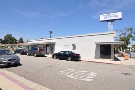
Property Detail
102 Alabama St Aka 215-219 East La Dr
5367-034-021
TRACT # 7720 LOT COM AT SW COR OF LOT 69 TH N 82 54 E 50.4 FT TH N 0 0430 E 108.06 FT TH N 89 47 W 50 FT TH S 0 04 30 W 114.47 FT TO BEG PART OF LOT 69
Storemultistory
LOS ANGELES
SLC1*
California
B and X Area of moderate flood hazard, usually the area between the limits of the 100-year and 500-year floods.
69
2025
0.13 AC
2025
Western SGV
480002
Los Angeles
3,256 SF
Los Angeles-Long Beach-Glendale, CA
NEARBY LISTINGS FOR SALE OR LEASE
DEMOGRAPHICS near 102 Alabama St Aka 215-219 East La Dr
1 mile
3 mile
5 mile
2025 Total Population
25,425
242,090
609,419
2030 Population
25,118
239,843
604,079
Pop Growth 2025-2030
(1.21%)
(0.93%)
(0.88%)
Average Age
43
43
42
2025 Total Households
8,521
81,594
211,234
HH Growth 2025-2030
(1.43%)
(1.14%)
(1.03%)
Median Household Inc
$99,449
$92,908
$94,453
Avg Household Size
2.90
2.90
2.80
2025 Avg HH Vehicles
2.00
2.00
2.00
Median Home Value
$985,188
$966,385
$935,895
Median Year Built
1957
1959
1960
Nearby Places
Map Layers
Map Styles
 Street
 Aerial
Layers
 Traffic
 Biking
Places
Listings with unknown addresses are not visible on the map
- Restaurants
- Banks
- Shops
- Fitness
- Groceries
PUBLIC TRANSPORTATION
COMMUTER RAIL
El Monte (San Bernardino Line - Southern California Regional Rail Authority (Metrolink))
Drive
Walk
Distance
El Monte (San Bernardino Line - Southern California Regional Rail Authority (Metrolink))
11 min
4.7 mi
Montebello/Commerce (Riverside Line - Southern California Regional Rail Authority (Metrolink))
Drive
Walk
Distance
Montebello/Commerce (Riverside Line - Southern California Regional Rail Authority (Metrolink))
18 min
8.2 mi
AIRPORT
Bob Hope
Drive
Walk
Distance
Bob Hope
34 min
23.3 mi
Long Beach (Daugherty Field)
Drive
Walk
Distance
Long Beach (Daugherty Field)
38 min
24.8 mi
Los Angeles International
Drive
Walk
Distance
Los Angeles International
41 min
26.0 mi
SALE & LEASE HISTORY
LISTING DATE
SALE/LEASE

Sep 15, 2024
For Sale
Jan 09, 2020
For Sale
Feb 13, 2020
For Sale
Aug 30, 2025
For Lease
Aug 13, 2018
For Sale
Nearby Properties
Address
Land Use
TOTAL SIZE
Lot Size
Zoning
Address
Land Use
TOTAL SIZE
Lot Size
Zoning
11,590 SF
14.43 AC
PSC*
Address
Land Use
TOTAL SIZE
Lot Size
Zoning
91,229 SF
206.59 AC
SOH
Address
Land Use
TOTAL SIZE
Lot Size
Zoning
516,474 SF
4.37 AC
ALCBD/DRD*
Address
Land Use
TOTAL SIZE
Lot Size
Zoning
192,792 SF
14.52 AC
PSR
Address
Land Use
TOTAL SIZE
Lot Size
Zoning
247,960 SF
1.99 AC
SLC3
Address
Land Use
TOTAL SIZE
Lot Size
Zoning
593,133 SF
SLR1YY
Address
Land Use
TOTAL SIZE
Lot Size
Zoning
452,713 SF
28.21 AC
PSC*
Address
Land Use
TOTAL SIZE
Lot Size
Zoning
220,142 SF
9.92 AC
SLR1VV
Address
Land Use
TOTAL SIZE
Lot Size
Zoning
198,728 SF
2.50 AC
SLR3YY
Address
Land Use
TOTAL SIZE
Lot Size
Zoning
331,660 SF
7.34 AC
RMC3*
Address
Land Use
TOTAL SIZE
Lot Size
Zoning
320,844 SF
6.45 AC
SLCHR*
Address
Land Use
TOTAL SIZE
Lot Size
Zoning
168,334 SF
7.41 AC
EMM2*
Address
Land Use
TOTAL SIZE
Lot Size
Zoning
255,384 SF
6.74 AC
ARC2*
Address
Land Use
TOTAL SIZE
Lot Size
Zoning
95,187 SF
3.10 AC
EMC4*
Address
Land Use
TOTAL SIZE
Lot Size
Zoning
85,890 SF
2.33 AC
MPR2SCH*
Address
Land Use
TOTAL SIZE
Lot Size
Zoning
53,306 SF
0.90 AC
ARC2
Address
Land Use
TOTAL SIZE
Lot Size
Zoning
69,352 SF
4.78 AC
ARC2
Address
Land Use
TOTAL SIZE
Lot Size
Zoning
213,932 SF
7.03 AC
EMM2*
Address
Land Use
TOTAL SIZE
Lot Size
Zoning
48,018 SF
2.64 AC
SLC3*
Address
Land Use
TOTAL SIZE
Lot Size
Zoning
90,886 SF
TCC3*
Address
Land Use
TOTAL SIZE
Lot Size
Zoning
54,368 SF
1.20 AC
SLR3YY
Address
Land Use
TOTAL SIZE
Lot Size
Zoning
82,188 SF
1.20 AC
ALCBD/DRD*
Address
Land Use
TOTAL SIZE
Lot Size
Zoning
41,761 SF
3.25 AC
ALCPD-R1*
Address
Land Use
TOTAL SIZE
Lot Size
Zoning
139,100 SF
6.45 AC
EMM2*
Address
Land Use
TOTAL SIZE
Lot Size
Zoning
60,919 SF
1.47 AC
SLR3YY
Address
Land Use
TOTAL SIZE
Lot Size
Zoning
170,198 SF
3.84 AC
MPOP
Address
Land Use
TOTAL SIZE
Lot Size
Zoning
72,925 SF
8.99 AC
PSC*
Address
Land Use
TOTAL SIZE
Lot Size
Zoning
18,768 SF
0.86 AC
SLC3-R3*
Address
Land Use
TOTAL SIZE
Lot Size
Zoning
302,190 SF
10.03 AC
ALCO*
The World's #1 Commercial Real Estate Marketplace
Connect with us
© 2026 CoStar Group
The information above has been obtained from sources believed reliable. While we do not doubt its accuracy we have not verified it and make no guarantee, warranty or representation about it. It is your responsibility to independently confirm its accuracy and completeness. Any projections, opinions, assumptions, or estimates used are for example only and do not represent the current or future performance of the property. The value of this transaction to you depends on tax and other factors which should be evaluated by your tax, financial, and legal advisors. You and your advisors should conduct a careful, independent investigation of the property to determine to your satisfaction the suitability of the property for your needs.