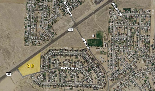
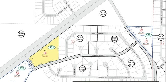
Property Record
102 Ambrose Ln, Dayton, NV 89403

Property Detail
102 Ambrose Ln
Reno, NV
32-17-22 POR S2 S2 CREATED BY CONSOLIDATION OF THESE PARCEL #S: 019-522-06 019-522-05 019-522-04 019-522-03 019-522-02 019-522-01 RA 290666 2-11-2003 CREATED FROM SPLIT OF PARCEL # 019-522-07 BLUE STONE EST PH 3
019-522-08
LYON
Commercialacreage
Nevada
C2
154
AO River or stream flood hazard areas, and areas with a 1% or greater chance of shallow flooding each year. These areas have a 26% chance of flooding over the life of a 30-year mortgage.
5.75 AC
2026
Lyon County
2025
Reno/Sparks
960304
NEARBY LISTINGS FOR SALE OR LEASE
DEMOGRAPHICS near 102 Ambrose Ln
1 mile
3 mile
5 mile
2025 Total Population
3,279
12,881
17,928
2030 Population
3,448
13,616
18,943
Pop Growth 2025-2030
+ 5.15%
+ 5.71%
+ 5.66%
Average Age
44
44
44
2025 Total Households
1,238
4,926
6,976
HH Growth 2025-2030
+ 5.09%
+ 5.68%
+ 5.62%
Median Household Inc
$97,646
$92,927
$91,358
Avg Household Size
2.60
2.60
2.60
2025 Avg HH Vehicles
3.00
3.00
2.00
Median Home Value
$405,097
$417,930
$426,521
Median Year Built
2000
2001
2001
Nearby Places
Map Layers
Map Styles
 Street
 Aerial
Layers
 Traffic
 Biking
Places
Listings with unknown addresses are not visible on the map
- Restaurants
- Banks
- Shops
- Fitness
- Groceries
PUBLIC TRANSPORTATION
AIRPORT
Reno/Tahoe International
Drive
Walk
Distance
Reno/Tahoe International
70 min
32.9 mi
Freight Ports
Port of Stockton
Drive
Walk
Distance
Port of Stockton
242 min
167.7 mi
Nearby Properties
Address
Land Use
TOTAL SIZE
Lot Size
Zoning
Address
Land Use
TOTAL SIZE
Lot Size
Zoning
50,495 SF
10.76 AC
E1
Address
Land Use
TOTAL SIZE
Lot Size
Zoning
9,804 SF
3.31 AC
MFR
Address
Land Use
TOTAL SIZE
Lot Size
Zoning
47,941 SF
10.33 AC
MULT
Address
Land Use
TOTAL SIZE
Lot Size
Zoning
24.60 AC
MULT
Address
Land Use
TOTAL SIZE
Lot Size
Zoning
1,579 SF
6.73 AC
C2
Address
Land Use
TOTAL SIZE
Lot Size
Zoning
9,600 SF
4.50 AC
C2
Address
Land Use
TOTAL SIZE
Lot Size
Zoning
5,760 SF
3 AC
M1
Address
Land Use
TOTAL SIZE
Lot Size
Zoning
19,934 SF
2.18 AC
C2
Address
Land Use
TOTAL SIZE
Lot Size
Zoning
35,000 SF
3 AC
M1
Address
Land Use
TOTAL SIZE
Lot Size
Zoning
3,600 SF
56.13 AC
MULT
Address
Land Use
TOTAL SIZE
Lot Size
Zoning
17.04 AC
C2
Address
Land Use
TOTAL SIZE
Lot Size
Zoning
672 SF
5.37 AC
C2
Address
Land Use
TOTAL SIZE
Lot Size
Zoning
29,290 SF
2 AC
M1
Address
Land Use
TOTAL SIZE
Lot Size
Zoning
18,456 SF
1.35 AC
C2
Address
Land Use
TOTAL SIZE
Lot Size
Zoning
37,200 SF
5.55 AC
M1
Address
Land Use
TOTAL SIZE
Lot Size
Zoning
15,543 SF
1.44 AC
C2
Address
Land Use
TOTAL SIZE
Lot Size
Zoning
4,644 SF
1.18 AC
C2
Address
Land Use
TOTAL SIZE
Lot Size
Zoning
4,537 SF
35.19 AC
RR2T
Address
Land Use
TOTAL SIZE
Lot Size
Zoning
12.39 AC
C2
Address
Land Use
TOTAL SIZE
Lot Size
Zoning
1,620 SF
2.81 AC
C2
Address
Land Use
TOTAL SIZE
Lot Size
Zoning
5.67 AC
C2
Address
Land Use
TOTAL SIZE
Lot Size
Zoning
7,380 SF
1.07 AC
MULT
Address
Land Use
TOTAL SIZE
Lot Size
Zoning
8.86 AC
MULT
Address
Land Use
TOTAL SIZE
Lot Size
Zoning
2,400 SF
3.01 AC
C2
Address
Land Use
TOTAL SIZE
Lot Size
Zoning
5,250 SF
2.15 AC
M1
Address
Land Use
TOTAL SIZE
Lot Size
Zoning
7,771 SF
1.21 AC
C2
Address
Land Use
TOTAL SIZE
Lot Size
Zoning
10,125 SF
2.03 AC
C2
Address
Land Use
TOTAL SIZE
Lot Size
Zoning
230.76 AC
MULT
Address
Land Use
TOTAL SIZE
Lot Size
Zoning
5,952 SF
3.50 AC
M1
Address
Land Use
TOTAL SIZE
Lot Size
Zoning
7,488 SF
5.07 AC
C2
The World's #1 Commercial Real Estate Marketplace
Connect with us
© 2026 CoStar Group
The information above has been obtained from sources believed reliable. While we do not doubt its accuracy we have not verified it and make no guarantee, warranty or representation about it. It is your responsibility to independently confirm its accuracy and completeness. Any projections, opinions, assumptions, or estimates used are for example only and do not represent the current or future performance of the property. The value of this transaction to you depends on tax and other factors which should be evaluated by your tax, financial, and legal advisors. You and your advisors should conduct a careful, independent investigation of the property to determine to your satisfaction the suitability of the property for your needs.