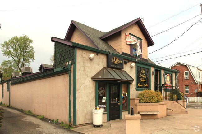
Property Record
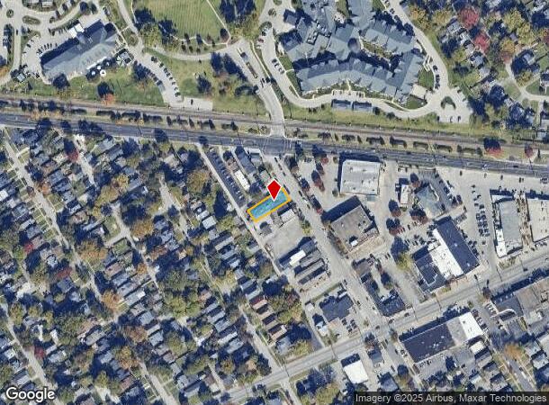
102 Bauer Ave, Louisville, KY 40207

NEARBY LISTINGS FOR SALE OR LEASE
Property Detail
102 Bauer Ave
Louisville-Jefferson County, KY-IN
Elmwood
040600050005
LOT 5 BLK 1, E T SCHMITTS SUBDIVISION PB.2, PG.82, 0.1446 AC +/-
Restaurantbuilding
Jefferson
X
Kentucky
21111C0028F
5
2024
0.14 AC
2024
Westport Rd/Brownsboro Rd
007800
Louisville
4,527 SF
DEMOGRAPHICS near 102 Bauer Ave
1 Mile
3 Mile
5 Mile
2024 Total Population
12,316
82,581
227,180
2029 Population
12,255
81,442
225,619
Pop Growth 2024-2029
(0.50%)
(1.38%)
(0.69%)
Average Age
44
42
41
2024 Total Households
5,567
39,226
104,478
HH Growth 2024-2029
(0.56%)
(1.34%)
(0.67%)
Median Household Inc
$92,605
$77,899
$68,194
Avg Household Size
2.10
2.00
2.10
2024 Avg HH Vehicles
2.00
2.00
2.00
Median Home Value
$377,648
$327,727
$268,012
Median Year Built
1952
1957
1964
Nearby Places
Map Layers
Map Styles
 Street
 Aerial
- Restaurants
- Banks
- Shops
- Fitness
- Groceries
PUBLIC TRANSPORTATION
AIRPORT
Louisville Muhammad Ali International
DRIVE
WALK
Distance
Louisville Muhammad Ali International
22 min
11.8 mi
Nearby Properties
Address
Land Use
TOTAL SIZE
Lot Size
Zoning
Address
Land Use
TOTAL SIZE
Lot Size
Zoning
806,417 SF
43.50 AC
C2-COMMERC
Address
Land Use
TOTAL SIZE
Lot Size
Zoning
106,338 SF
17.28 AC
C2-COMMERC
Address
Land Use
TOTAL SIZE
Lot Size
Zoning
Address
Land Use
TOTAL SIZE
Lot Size
Zoning
499,626 SF
33.47 AC
C1-COMMERC
Address
Land Use
TOTAL SIZE
Lot Size
Zoning
16.41 AC
C1-COMMERC
Address
Land Use
TOTAL SIZE
Lot Size
Zoning
8,632 SF
20.91 AC
OR3-OFFICE
Address
Land Use
TOTAL SIZE
Lot Size
Zoning
8,677 SF
26.10 AC
R7-RESIDEN
Address
Land Use
TOTAL SIZE
Lot Size
Zoning
6,754 SF
21.80 AC
C2-COMMERC
Address
Land Use
TOTAL SIZE
Lot Size
Zoning
11,168 SF
13.69 AC
OR3-OFFICE
Address
Land Use
TOTAL SIZE
Lot Size
Zoning
11,480 SF
15.29 AC
OR3-OFFICE
Address
Land Use
TOTAL SIZE
Lot Size
Zoning
211,009 SF
19.71 AC
C2-COMMERC
Address
Land Use
TOTAL SIZE
Lot Size
Zoning
34.06 AC
Address
Land Use
TOTAL SIZE
Lot Size
Zoning
10,080 SF
28.04 AC
OR3-OFFICE
Address
Land Use
TOTAL SIZE
Lot Size
Zoning
8,820 SF
22.62 AC
R7-RESIDEN
Address
Land Use
TOTAL SIZE
Lot Size
Zoning
77,585 SF
3.50 AC
C2-COMMERC
Address
Land Use
TOTAL SIZE
Lot Size
Zoning
400 SF
13.92 AC
R6-RESIDEN
Address
Land Use
TOTAL SIZE
Lot Size
Zoning
34,805 SF
13.43 AC
C1-COMMERC
Address
Land Use
TOTAL SIZE
Lot Size
Zoning
148,682 SF
0.74 AC
OR3-OFFICE
Address
Land Use
TOTAL SIZE
Lot Size
Zoning
6,825 SF
21.55 AC
R6-RESIDEN
Address
Land Use
TOTAL SIZE
Lot Size
Zoning
147,397 SF
9.59 AC
Address
Land Use
TOTAL SIZE
Lot Size
Zoning
6.81 AC
C1-COMMERC
Address
Land Use
TOTAL SIZE
Lot Size
Zoning
92,412 SF
0.87 AC
OR3-OFFICE
Address
Land Use
TOTAL SIZE
Lot Size
Zoning
3,008 SF
15.22 AC
R7-RESIDEN
Address
Land Use
TOTAL SIZE
Lot Size
Zoning
2,638 SF
8.96 AC
C1-COMMERC
Address
Land Use
TOTAL SIZE
Lot Size
Zoning
99,477 SF
11.46 AC
C2-COMMERC
Address
Land Use
TOTAL SIZE
Lot Size
Zoning
2,032 SF
6.48 AC
R7-RESIDEN
Address
Land Use
TOTAL SIZE
Lot Size
Zoning
143,321 SF
16.67 AC
C2-COMMERC
Address
Land Use
TOTAL SIZE
Lot Size
Zoning
133,676 SF
9.35 AC
C2-COMMERC
Address
Land Use
TOTAL SIZE
Lot Size
Zoning
67,068 SF
7.88 AC
OR3-OFFICE
Address
Land Use
TOTAL SIZE
Lot Size
Zoning
92,295 SF
5.15 AC
OTF-OFFICE
The World's #1 Commercial Real Estate Marketplace
Connect with us
© 2025 CoStar Group
The information above has been obtained from sources believed reliable. While we do not doubt its accuracy we have not verified it and make no guarantee, warranty or representation about it. It is your responsibility to independently confirm its accuracy and completeness. Any projections, opinions, assumptions, or estimates used are for example only and do not represent the current or future performance of the property. The value of this transaction to you depends on tax and other factors which should be evaluated by your tax, financial, and legal advisors. You and your advisors should conduct a careful, independent investigation of the property to determine to your satisfaction the suitability of the property for your needs.