Property Record
102 Browne St, Oneonta, NY 13820

Save to a Folder
{{folder.Name}}
{{folder.ListingIds.length}} Properties
{{folder.ListingIds.length}} Property
Create a New Folder
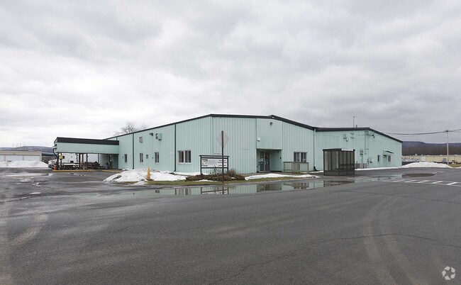
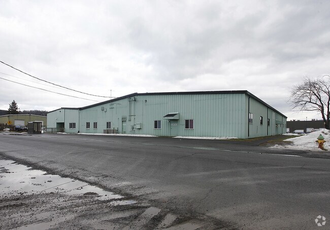
Property Detail
102 Browne St
364600-299-000-0001-008-000-0000
980 0 0
Manufacturinglight
Otsego
01
New York
B and X Area of moderate flood hazard, usually the area between the limits of the 100-year and 500-year floods.
8.000
2025
1.44 AC
2025
Otsego County
590800
Albany/Schenectady/Troy
26,000 SF
Oneonta, NY
NEARBY LISTINGS FOR SALE OR LEASE
DEMOGRAPHICS near 102 Browne St
1 mile
3 mile
5 mile
2025 Total Population
2,154
18,650
22,362
2030 Population
2,151
18,807
22,473
Pop Growth 2025-2030
(0.14%)
+ 0.84%
+ 0.50%
Average Age
46
35
37
2025 Total Households
842
5,366
6,872
HH Growth 2025-2030
(0.59%)
+ 0.11%
(0.20%)
Median Household Inc
$64,077
$62,302
$63,846
Avg Household Size
2.10
2.10
2.10
2025 Avg HH Vehicles
2.00
1.00
2.00
Median Home Value
$168,621
$188,301
$186,685
Median Year Built
1957
1948
1949
Nearby Places
Map Layers
Map Styles
 Street
 Aerial
Layers
 Traffic
 Biking
Places
Listings with unknown addresses are not visible on the map
- Restaurants
- Banks
- Shops
- Fitness
- Groceries
Nearby Properties
Address
Land Use
TOTAL SIZE
Lot Size
Zoning
Address
Land Use
TOTAL SIZE
Lot Size
Zoning
44,216 SF
106.49 AC
610
Address
Land Use
TOTAL SIZE
Lot Size
Zoning
10,927 SF
142.34 AC
610
Address
Land Use
TOTAL SIZE
Lot Size
Zoning
204.26 AC
01
Address
Land Use
TOTAL SIZE
Lot Size
Zoning
216,150 SF
3.04 AC
610
Address
Land Use
TOTAL SIZE
Lot Size
Zoning
103.77 AC
01
Address
Land Use
TOTAL SIZE
Lot Size
Zoning
126,759 SF
0.97 AC
610
Address
Land Use
TOTAL SIZE
Lot Size
Zoning
170,000 SF
15.79 AC
120
Address
Land Use
TOTAL SIZE
Lot Size
Zoning
130,300 SF
20.06 AC
PDD-R
Address
Land Use
TOTAL SIZE
Lot Size
Zoning
Address
Land Use
TOTAL SIZE
Lot Size
Zoning
8,400 SF
65.53 AC
510
Address
Land Use
TOTAL SIZE
Lot Size
Zoning
42,000 SF
2.06 AC
230
Address
Land Use
TOTAL SIZE
Lot Size
Zoning
115,435 SF
18.72 AC
230
Address
Land Use
TOTAL SIZE
Lot Size
Zoning
71,504 SF
4.09 AC
Address
Land Use
TOTAL SIZE
Lot Size
Zoning
36,629 SF
2.11 AC
610
Address
Land Use
TOTAL SIZE
Lot Size
Zoning
83,256 SF
1.30 AC
620
Address
Land Use
TOTAL SIZE
Lot Size
Zoning
84,790 SF
2.11 AC
150
Address
Land Use
TOTAL SIZE
Lot Size
Zoning
3,600 SF
63.84 AC
01
Address
Land Use
TOTAL SIZE
Lot Size
Zoning
64,072 SF
1.53 AC
330
Address
Land Use
TOTAL SIZE
Lot Size
Zoning
113.33 AC
520
Address
Land Use
TOTAL SIZE
Lot Size
Zoning
67,224 SF
8.11 AC
Address
Land Use
TOTAL SIZE
Lot Size
Zoning
0.01 AC
Address
Land Use
TOTAL SIZE
Lot Size
Zoning
55,648 SF
9.90 AC
Address
Land Use
TOTAL SIZE
Lot Size
Zoning
83,384 SF
10.45 AC
Address
Land Use
TOTAL SIZE
Lot Size
Zoning
8,839 SF
15.16 AC
140
Address
Land Use
TOTAL SIZE
Lot Size
Zoning
73,580 SF
0.51 AC
310
Address
Land Use
TOTAL SIZE
Lot Size
Zoning
39,872 SF
4.10 AC
230
Address
Land Use
TOTAL SIZE
Lot Size
Zoning
49,047 SF
11.37 AC
01
Address
Land Use
TOTAL SIZE
Lot Size
Zoning
50,000 SF
16.41 AC
120
Address
Land Use
TOTAL SIZE
Lot Size
Zoning
37,536 SF
10.36 AC
620
Address
Land Use
TOTAL SIZE
Lot Size
Zoning
6,528 SF
8.64 AC
The World's #1 Commercial Real Estate Marketplace
Connect with us
© 2026 CoStar Group
The information above has been obtained from sources believed reliable. While we do not doubt its accuracy we have not verified it and make no guarantee, warranty or representation about it. It is your responsibility to independently confirm its accuracy and completeness. Any projections, opinions, assumptions, or estimates used are for example only and do not represent the current or future performance of the property. The value of this transaction to you depends on tax and other factors which should be evaluated by your tax, financial, and legal advisors. You and your advisors should conduct a careful, independent investigation of the property to determine to your satisfaction the suitability of the property for your needs.