Property Record
102 E Mauldin St, Anderson, SC 29621
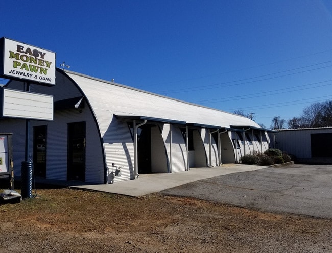

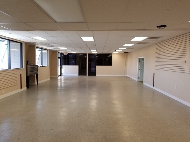
Property Detail
102 E Mauldin St
Greenville-Anderson-Greer, SC
CP 2609/7 PP S 1155/8A F000 D000 PP 023/069 LT A E MAULDIN ST .73 AC
123-27-02-019
Anderson
Warehouse
South Carolina
B and X Area of moderate flood hazard, usually the area between the limits of the 100-year and 500-year floods.
a
2025
0.73 AC
2024
Anderson Cy S of I-85
000200
Greenville/Spartanburg
9,898 SF
NEARBY LISTINGS FOR SALE OR LEASE
DEMOGRAPHICS near 102 E Mauldin St
1 mile
3 mile
5 mile
2024 Total Population
8,244
47,323
79,464
2029 Population
8,744
50,055
83,806
Pop Growth 2024-2029
+ 6.07%
+ 5.77%
+ 5.46%
Average Age
38
39
40
2024 Total Households
3,118
19,193
31,854
HH Growth 2024-2029
+ 6.06%
+ 5.86%
+ 5.60%
Median Household Inc
$57,104
$49,943
$55,914
Avg Household Size
2.30
2.30
2.40
2024 Avg HH Vehicles
2.00
2.00
2.00
Median Home Value
$213,711
$223,185
$227,455
Median Year Built
1963
1979
1983
Nearby Places
Map Layers
Map Styles
 Street
 Aerial
Transit
 Traffic
 Biking
Places
Listings with unknown addresses are not visible on the map
- Restaurants
- Banks
- Shops
- Fitness
- Groceries
SALE & LEASE HISTORY
LISTING DATE
SALE/LEASE

Oct 03, 2017
For Sale
Jun 22, 2020
For Sale
Jan 03, 2020
For Lease
Aug 22, 2022
For Lease
Aug 10, 2022
For Sale
Aug 03, 2018
For Sale
Nearby Properties
Address
Land Use
TOTAL SIZE
Lot Size
Zoning
Address
Land Use
TOTAL SIZE
Lot Size
Zoning
27,519 SF
20.80 AC
Address
Land Use
TOTAL SIZE
Lot Size
Zoning
17,286 SF
19.71 AC
Address
Land Use
TOTAL SIZE
Lot Size
Zoning
2,778 SF
12.37 AC
Address
Land Use
TOTAL SIZE
Lot Size
Zoning
2,027 SF
12.16 AC
Address
Land Use
TOTAL SIZE
Lot Size
Zoning
15,168 SF
11.99 AC
Address
Land Use
TOTAL SIZE
Lot Size
Zoning
183,500 SF
19.79 AC
Address
Land Use
TOTAL SIZE
Lot Size
Zoning
1,210 SF
16.52 AC
Address
Land Use
TOTAL SIZE
Lot Size
Zoning
27,441 SF
5.49 AC
Address
Land Use
TOTAL SIZE
Lot Size
Zoning
7,568 SF
10.99 AC
Address
Land Use
TOTAL SIZE
Lot Size
Zoning
118,242 SF
10.63 AC
Address
Land Use
TOTAL SIZE
Lot Size
Zoning
71,276 SF
4.07 AC
Address
Land Use
TOTAL SIZE
Lot Size
Zoning
1,475 SF
9.65 AC
Address
Land Use
TOTAL SIZE
Lot Size
Zoning
1,328 SF
8.79 AC
Address
Land Use
TOTAL SIZE
Lot Size
Zoning
121,232 SF
19.72 AC
Address
Land Use
TOTAL SIZE
Lot Size
Zoning
45,014 SF
0.29 AC
Address
Land Use
TOTAL SIZE
Lot Size
Zoning
121,900 SF
11.39 AC
Address
Land Use
TOTAL SIZE
Lot Size
Zoning
729 SF
10 AC
Address
Land Use
TOTAL SIZE
Lot Size
Zoning
53,002 SF
15.97 AC
Address
Land Use
TOTAL SIZE
Lot Size
Zoning
188,745 SF
20.01 AC
Address
Land Use
TOTAL SIZE
Lot Size
Zoning
87,670 SF
5.81 AC
Address
Land Use
TOTAL SIZE
Lot Size
Zoning
135,174 SF
27.88 AC
Address
Land Use
TOTAL SIZE
Lot Size
Zoning
42,416 SF
6.45 AC
Address
Land Use
TOTAL SIZE
Lot Size
Zoning
134,827 SF
14.32 AC
Address
Land Use
TOTAL SIZE
Lot Size
Zoning
40,071 SF
18.83 AC
Address
Land Use
TOTAL SIZE
Lot Size
Zoning
27,372 SF
2.49 AC
Address
Land Use
TOTAL SIZE
Lot Size
Zoning
1,983 SF
14.26 AC
Address
Land Use
TOTAL SIZE
Lot Size
Zoning
25,908 SF
12.50 AC
Address
Land Use
TOTAL SIZE
Lot Size
Zoning
49,123 SF
5.14 AC
Address
Land Use
TOTAL SIZE
Lot Size
Zoning
61,281 SF
0.74 AC
The World's #1 Commercial Real Estate Marketplace
Connect with us
© 2026 CoStar Group
The information above has been obtained from sources believed reliable. While we do not doubt its accuracy we have not verified it and make no guarantee, warranty or representation about it. It is your responsibility to independently confirm its accuracy and completeness. Any projections, opinions, assumptions, or estimates used are for example only and do not represent the current or future performance of the property. The value of this transaction to you depends on tax and other factors which should be evaluated by your tax, financial, and legal advisors. You and your advisors should conduct a careful, independent investigation of the property to determine to your satisfaction the suitability of the property for your needs.