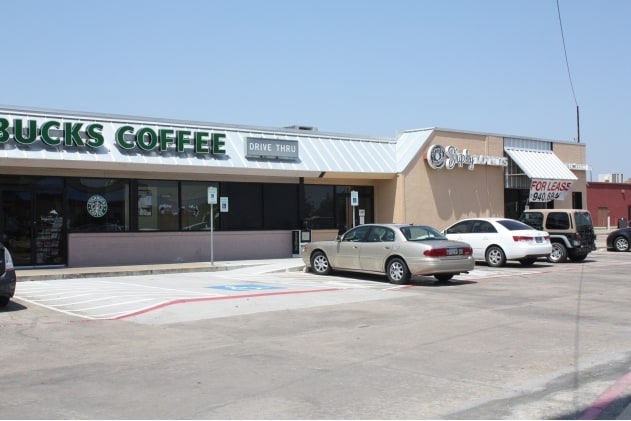
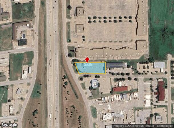
Property Record
102 I 35 Hwy Ne, Hillsboro, TX 76645
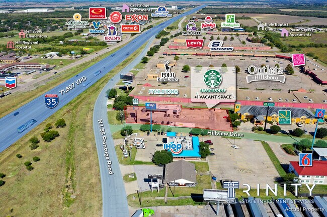
NEARBY LISTINGS FOR SALE OR LEASE
Property Detail
102 I 35 Hwy Ne
141378
H Weatherly A-
Commercialnec
H WEATHERLY A-972 TR 37D 1.00 AC
X
Hill
48217C0265D
Texas
2025
1 AC
2025
Central Texas Area
961100
Other Market Areas
39,718 SF
DEMOGRAPHICS near 102 I 35 Hwy Ne
1 Mile
3 Mile
5 Mile
2024 Total Population
2,478
9,674
10,319
2029 Population
2,675
10,632
11,323
Pop Growth 2024-2029
+ 7.95%
+ 9.90%
+ 9.73%
Average Age
41
37
38
2024 Total Households
979
3,458
3,698
HH Growth 2024-2029
+ 7.66%
+ 9.60%
+ 9.44%
Median Household Inc
$57,970
$57,317
$58,301
Avg Household Size
2.50
2.70
2.70
2024 Avg HH Vehicles
2.00
2.00
2.00
Median Home Value
$166,402
$112,986
$119,274
Median Year Built
1983
1978
1978
Nearby Places
Map Layers
Map Styles
 Street
 Aerial
- Restaurants
- Banks
- Shops
- Fitness
- Groceries
PUBLIC TRANSPORTATION
AIRPORT
Waco Regional
DRIVE
WALK
Distance
Waco Regional
51 min
38.6 mi
SALE & LEASE HISTORY
LISTING DATE
SALE/LEASE

Nov 07, 2019
For Lease
Nov 05, 2021
For Sale
Mar 21, 2017
For Sale
Jun 13, 2017
For Sale
Jan 13, 2020
For Sale
Dec 19, 2022
For Lease
Nearby Properties
Address
Land Use
TOTAL SIZE
Lot Size
Zoning
Address
Land Use
TOTAL SIZE
Lot Size
Zoning
383,088 SF
78.94 AC
Address
Land Use
TOTAL SIZE
Lot Size
Zoning
269,487 SF
70 AC
Address
Land Use
TOTAL SIZE
Lot Size
Zoning
Address
Land Use
TOTAL SIZE
Lot Size
Zoning
92,578 SF
45.82 AC
Address
Land Use
TOTAL SIZE
Lot Size
Zoning
148,714 SF
14.92 AC
Address
Land Use
TOTAL SIZE
Lot Size
Zoning
192,060 SF
19.46 AC
Address
Land Use
TOTAL SIZE
Lot Size
Zoning
754,116 SF
77.64 AC
Address
Land Use
TOTAL SIZE
Lot Size
Zoning
273,551 SF
20.23 AC
Address
Land Use
TOTAL SIZE
Lot Size
Zoning
72,358 SF
13.99 AC
Address
Land Use
TOTAL SIZE
Lot Size
Zoning
47,404 SF
9.94 AC
Address
Land Use
TOTAL SIZE
Lot Size
Zoning
56,252 SF
19.36 AC
Address
Land Use
TOTAL SIZE
Lot Size
Zoning
547,093 SF
16.06 AC
Address
Land Use
TOTAL SIZE
Lot Size
Zoning
29,083 SF
2.50 AC
Address
Land Use
TOTAL SIZE
Lot Size
Zoning
633,604 SF
27.95 AC
Address
Land Use
TOTAL SIZE
Lot Size
Zoning
60,680 SF
3.48 AC
Address
Land Use
TOTAL SIZE
Lot Size
Zoning
52,825 SF
5.71 AC
Address
Land Use
TOTAL SIZE
Lot Size
Zoning
64,590 SF
1.94 AC
Address
Land Use
TOTAL SIZE
Lot Size
Zoning
145,567 SF
8.26 AC
Address
Land Use
TOTAL SIZE
Lot Size
Zoning
80,120 SF
9.87 AC
Address
Land Use
TOTAL SIZE
Lot Size
Zoning
85,963 SF
30.94 AC
Address
Land Use
TOTAL SIZE
Lot Size
Zoning
208,710 SF
4.81 AC
Address
Land Use
TOTAL SIZE
Lot Size
Zoning
Address
Land Use
TOTAL SIZE
Lot Size
Zoning
113,469 SF
4.78 AC
Address
Land Use
TOTAL SIZE
Lot Size
Zoning
38,712 SF
4.71 AC
Address
Land Use
TOTAL SIZE
Lot Size
Zoning
94,201 SF
4.52 AC
Address
Land Use
TOTAL SIZE
Lot Size
Zoning
262,478 SF
14.42 AC
Address
Land Use
TOTAL SIZE
Lot Size
Zoning
133,654 SF
19.25 AC
Address
Land Use
TOTAL SIZE
Lot Size
Zoning
159,465 SF
4.54 AC
Address
Land Use
TOTAL SIZE
Lot Size
Zoning
35,832 SF
1.83 AC
Address
Land Use
TOTAL SIZE
Lot Size
Zoning
47,850 SF
48.58 AC
The World's #1 Commercial Real Estate Marketplace
Connect with us
© 2025 CoStar Group
The information above has been obtained from sources believed reliable. While we do not doubt its accuracy we have not verified it and make no guarantee, warranty or representation about it. It is your responsibility to independently confirm its accuracy and completeness. Any projections, opinions, assumptions, or estimates used are for example only and do not represent the current or future performance of the property. The value of this transaction to you depends on tax and other factors which should be evaluated by your tax, financial, and legal advisors. You and your advisors should conduct a careful, independent investigation of the property to determine to your satisfaction the suitability of the property for your needs.