Property Record
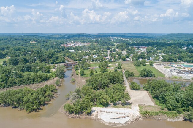
102 Mill St, Imperial, MO 63052
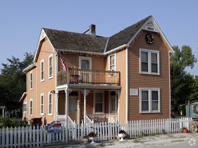

Property Detail
102 Mill St
09-5.0-21.0-2-003-003
TOWN OF KIMMSWICK LOTS 1 & 2 & PT 3 BLOCK 1
Storebuilding
Jefferson
CT1
Missouri
AE The base floodplain where base flood elevations are provided. AE Zones are now used on new format FIRMs instead of A1-A30 Zones.
1,2
2024
0.45 AC
2025
Southwest County
700114
St. Louis
2,348 SF
St. Louis, MO-IL
NEARBY LISTINGS FOR SALE OR LEASE
-
-
View all Imperial listings for sale on LoopNet.com
DEMOGRAPHICS near 102 Mill St
1 mile
3 mile
5 mile
2025 Total Population
1,468
17,213
53,005
2030 Population
1,509
17,351
53,327
Pop Growth 2025-2030
+ 2.79%
+ 0.80%
+ 0.61%
Average Age
42
40
40
2025 Total Households
568
6,521
19,641
HH Growth 2025-2030
+ 2.82%
+ 0.84%
+ 0.66%
Median Household Inc
$82,615
$89,196
$98,997
Avg Household Size
2.60
2.60
2.70
2025 Avg HH Vehicles
2.00
2.00
2.00
Median Home Value
$260,057
$261,249
$272,149
Median Year Built
1985
1990
1989
Nearby Places
Map Layers
Map Styles
 Street
 Aerial
Transit
 Traffic
 Biking
Places
Listings with unknown addresses are not visible on the map
- Restaurants
- Banks
- Shops
- Fitness
- Groceries
PUBLIC TRANSPORTATION
AIRPORT
St Louis Lambert International
Drive
Walk
Distance
St Louis Lambert International
50 min
32.6 mi
Scott AFB/Midamerica St Louis
Drive
Walk
Distance
Scott AFB/Midamerica St Louis
67 min
48.7 mi
SALE & LEASE HISTORY
LISTING DATE
SALE/LEASE

Jul 12, 2021
For Sale
Nearby Properties
Address
Land Use
TOTAL SIZE
Lot Size
Zoning
Address
Land Use
TOTAL SIZE
Lot Size
Zoning
67,628 SF
9.17 AC
CC2
Address
Land Use
TOTAL SIZE
Lot Size
Zoning
372,506 SF
25.50 AC
PUD
Address
Land Use
TOTAL SIZE
Lot Size
Zoning
15.10 AC
CC2
Address
Land Use
TOTAL SIZE
Lot Size
Zoning
33,734 SF
5.61 AC
CC2
Address
Land Use
TOTAL SIZE
Lot Size
Zoning
51,103 SF
10.83 AC
CC2
Address
Land Use
TOTAL SIZE
Lot Size
Zoning
46,010 SF
7.84 AC
CC2
Address
Land Use
TOTAL SIZE
Lot Size
Zoning
11,113 SF
1.03 AC
CC2
Address
Land Use
TOTAL SIZE
Lot Size
Zoning
81,590 SF
5.36 AC
CC2
Address
Land Use
TOTAL SIZE
Lot Size
Zoning
33,802 SF
5.07 AC
CC2
Address
Land Use
TOTAL SIZE
Lot Size
Zoning
69,807 SF
5.38 AC
CC2
Address
Land Use
TOTAL SIZE
Lot Size
Zoning
7,395 SF
4.75 AC
CC2
Address
Land Use
TOTAL SIZE
Lot Size
Zoning
15,035 SF
2.06 AC
CC2
Address
Land Use
TOTAL SIZE
Lot Size
Zoning
15,580 SF
1.88 AC
CT1
Address
Land Use
TOTAL SIZE
Lot Size
Zoning
77,283 SF
111.18 AC
Address
Land Use
TOTAL SIZE
Lot Size
Zoning
64,760 SF
5.91 AC
CC2
Address
Land Use
TOTAL SIZE
Lot Size
Zoning
8,365 SF
2.05 AC
Address
Land Use
TOTAL SIZE
Lot Size
Zoning
10,820 SF
1.37 AC
CC2
Address
Land Use
TOTAL SIZE
Lot Size
Zoning
5,274 SF
1.54 AC
CC2
Address
Land Use
TOTAL SIZE
Lot Size
Zoning
5,828 SF
0.94 AC
CC2
Address
Land Use
TOTAL SIZE
Lot Size
Zoning
76,210 SF
23.97 AC
R20
Address
Land Use
TOTAL SIZE
Lot Size
Zoning
14,525 SF
1.90 AC
CC2
Address
Land Use
TOTAL SIZE
Lot Size
Zoning
8,152 SF
1.97 AC
CC2
Address
Land Use
TOTAL SIZE
Lot Size
Zoning
9,301 SF
1.19 AC
Address
Land Use
TOTAL SIZE
Lot Size
Zoning
27,018 SF
2.53 AC
CC2
Address
Land Use
TOTAL SIZE
Lot Size
Zoning
5,160 SF
1.04 AC
CC2
Address
Land Use
TOTAL SIZE
Lot Size
Zoning
5,606 SF
1.45 AC
CC2
Address
Land Use
TOTAL SIZE
Lot Size
Zoning
60,100 SF
5.42 AC
PI
Address
Land Use
TOTAL SIZE
Lot Size
Zoning
5,228 SF
2 AC
Address
Land Use
TOTAL SIZE
Lot Size
Zoning
15,393 SF
94.18 AC
R40
The World's #1 Commercial Real Estate Marketplace
Connect with us
© 2026 CoStar Group
The information above has been obtained from sources believed reliable. While we do not doubt its accuracy we have not verified it and make no guarantee, warranty or representation about it. It is your responsibility to independently confirm its accuracy and completeness. Any projections, opinions, assumptions, or estimates used are for example only and do not represent the current or future performance of the property. The value of this transaction to you depends on tax and other factors which should be evaluated by your tax, financial, and legal advisors. You and your advisors should conduct a careful, independent investigation of the property to determine to your satisfaction the suitability of the property for your needs.