Property Record
102 N State Highway 342, Red Oak, TX 75154


Save to a Folder
{{folder.Name}}
{{folder.ListingIds.length}} Properties
{{folder.ListingIds.length}} Property
Create a New Folder
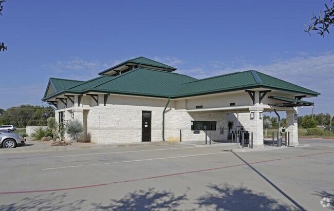
Property Detail
102 N State Highway 342
Dallas-Fort Worth-Arlington, TX
LOT 1R BLK 1 RED OAK CENTER ADDN .9979 AC
204783
ELLIS
Commercialnec
Texas
B and X Area of moderate flood hazard, usually the area between the limits of the 100-year and 500-year floods.
1r
2024
1 AC
2025
Southwest Outlying
060207
Dallas/Ft Worth
4,425 SF
NEARBY LISTINGS FOR SALE OR LEASE
DEMOGRAPHICS near 102 N State Highway 342
1 mile
3 mile
5 mile
2025 Total Population
7,417
30,419
73,580
2030 Population
8,636
35,537
82,970
Pop Growth 2025-2030
+ 16.44%
+ 16.83%
+ 12.76%
Average Age
36
38
38
2025 Total Households
2,510
10,197
24,570
HH Growth 2025-2030
+ 16.57%
+ 16.98%
+ 12.92%
Median Household Inc
$105,006
$94,340
$93,018
Avg Household Size
2.90
3.00
3.00
2025 Avg HH Vehicles
2.00
2.00
2.00
Median Home Value
$389,526
$360,050
$342,412
Median Year Built
2004
2000
2001
Nearby Places
Map Layers
Map Styles
 Street
 Aerial
Layers
 Traffic
 Biking
Places
Listings with unknown addresses are not visible on the map
- Restaurants
- Banks
- Shops
- Fitness
- Groceries
PUBLIC TRANSPORTATION
AIRPORT
Dallas Love Field
Drive
Walk
Distance
Dallas Love Field
38 min
25.9 mi
Dallas-Fort Worth International
Drive
Walk
Distance
Dallas-Fort Worth International
51 min
39.5 mi
Nearby Properties
Address
Land Use
TOTAL SIZE
Lot Size
Zoning
Address
Land Use
TOTAL SIZE
Lot Size
Zoning
268,416 SF
33.28 AC
Address
Land Use
TOTAL SIZE
Lot Size
Zoning
268,416 SF
19.04 AC
Address
Land Use
TOTAL SIZE
Lot Size
Zoning
268,416 SF
20.02 AC
Address
Land Use
TOTAL SIZE
Lot Size
Zoning
268,416 SF
19.18 AC
Address
Land Use
TOTAL SIZE
Lot Size
Zoning
364,814 SF
105.96 AC
Address
Land Use
TOTAL SIZE
Lot Size
Zoning
288,368 SF
86.46 AC
Address
Land Use
TOTAL SIZE
Lot Size
Zoning
316,312 SF
17.09 AC
Address
Land Use
TOTAL SIZE
Lot Size
Zoning
332,510 SF
18.45 AC
Address
Land Use
TOTAL SIZE
Lot Size
Zoning
268,416 SF
22.11 AC
Address
Land Use
TOTAL SIZE
Lot Size
Zoning
345,348 SF
19.22 AC
Address
Land Use
TOTAL SIZE
Lot Size
Zoning
281,216 SF
75.37 AC
Address
Land Use
TOTAL SIZE
Lot Size
Zoning
80,000 SF
8.37 AC
Address
Land Use
TOTAL SIZE
Lot Size
Zoning
268,416 SF
18.38 AC
Address
Land Use
TOTAL SIZE
Lot Size
Zoning
41,390 SF
90.38 AC
Address
Land Use
TOTAL SIZE
Lot Size
Zoning
104,885 SF
8 AC
Address
Land Use
TOTAL SIZE
Lot Size
Zoning
111,715 SF
4.81 AC
Address
Land Use
TOTAL SIZE
Lot Size
Zoning
268,416 SF
18.32 AC
Address
Land Use
TOTAL SIZE
Lot Size
Zoning
268,416 SF
91.89 AC
Address
Land Use
TOTAL SIZE
Lot Size
Zoning
110,065 SF
8.29 AC
Address
Land Use
TOTAL SIZE
Lot Size
Zoning
40,071 SF
15.96 AC
Address
Land Use
TOTAL SIZE
Lot Size
Zoning
159,860 SF
24.03 AC
Address
Land Use
TOTAL SIZE
Lot Size
Zoning
268,416 SF
19.64 AC
Address
Land Use
TOTAL SIZE
Lot Size
Zoning
91,204 SF
5.04 AC
Address
Land Use
TOTAL SIZE
Lot Size
Zoning
43,164 SF
17.44 AC
Address
Land Use
TOTAL SIZE
Lot Size
Zoning
268,416 SF
40.26 AC
Address
Land Use
TOTAL SIZE
Lot Size
Zoning
181,425 SF
38.96 AC
Address
Land Use
TOTAL SIZE
Lot Size
Zoning
51,744 SF
1.88 AC
Address
Land Use
TOTAL SIZE
Lot Size
Zoning
68,464 SF
16 AC
Address
Land Use
TOTAL SIZE
Lot Size
Zoning
49,015 SF
30.05 AC
Address
Land Use
TOTAL SIZE
Lot Size
Zoning
20,695 SF
2.10 AC
The World's #1 Commercial Real Estate Marketplace
Connect with us
© 2026 CoStar Group
The information above has been obtained from sources believed reliable. While we do not doubt its accuracy we have not verified it and make no guarantee, warranty or representation about it. It is your responsibility to independently confirm its accuracy and completeness. Any projections, opinions, assumptions, or estimates used are for example only and do not represent the current or future performance of the property. The value of this transaction to you depends on tax and other factors which should be evaluated by your tax, financial, and legal advisors. You and your advisors should conduct a careful, independent investigation of the property to determine to your satisfaction the suitability of the property for your needs.