Property Record
102 Ne Clark Dr, Verndale, MN 56481
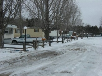
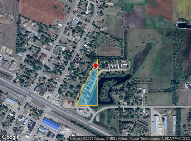
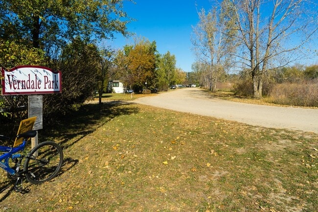
This Property Is For Sale
NEARBY LISTINGS FOR SALE OR LEASE
-
-
View all Verndale listings for sale on LoopNet.com
Property Detail
102 Ne Clark Dr
Other Market Areas
4.50 AC - ALL THAT PT OF SE1/4 SE1/4 DESCRIBED AS FOLLOWS:BEG AT THE SE CORNER OF SAID SE1/4 SE1/4;THN ON AN
21-019-4095
Wadena
Mobilehomepark
Minnesota
2025
4.50 AC
2025
Minnesota Central Area
480200
DEMOGRAPHICS near 102 Ne Clark Dr
1 Mile
3 Mile
5 Mile
2024 Total Population
533
765
1,370
2029 Population
546
781
1,397
Pop Growth 2024-2029
+ 2.44%
+ 2.09%
+ 1.97%
Average Age
41
41
41
2024 Total Households
241
335
567
HH Growth 2024-2029
+ 2.49%
+ 2.09%
+ 1.94%
Median Household Inc
$64,000
$65,407
$64,859
Avg Household Size
2.20
2.30
2.40
2024 Avg HH Vehicles
2.00
2.00
2.00
Median Home Value
$146,710
$148,598
$157,026
Median Year Built
1966
1969
1972
Nearby Places
Map Layers
Map Styles
 Street
 Aerial
- Restaurants
- Banks
- Shops
- Fitness
- Groceries
Nearby Properties
Address
Land Use
TOTAL SIZE
Lot Size
Zoning
Address
Land Use
TOTAL SIZE
Lot Size
Zoning
5.55 AC
Address
Land Use
TOTAL SIZE
Lot Size
Zoning
3,616 SF
264.75 AC
A3
Address
Land Use
TOTAL SIZE
Lot Size
Zoning
29,256 SF
11.81 AC
A3
Address
Land Use
TOTAL SIZE
Lot Size
Zoning
9.78 AC
A3
Address
Land Use
TOTAL SIZE
Lot Size
Zoning
1.42 AC
Address
Land Use
TOTAL SIZE
Lot Size
Zoning
0.34 AC
Address
Land Use
TOTAL SIZE
Lot Size
Zoning
383.10 AC
A3
Address
Land Use
TOTAL SIZE
Lot Size
Zoning
28,068 SF
280.68 AC
AF2
Address
Land Use
TOTAL SIZE
Lot Size
Zoning
1,528 SF
160 AC
A3
Address
Land Use
TOTAL SIZE
Lot Size
Zoning
1,852 SF
220 AC
A3
Address
Land Use
TOTAL SIZE
Lot Size
Zoning
1,632 SF
160 AC
A3
Address
Land Use
TOTAL SIZE
Lot Size
Zoning
1,242 SF
0.24 AC
Address
Land Use
TOTAL SIZE
Lot Size
Zoning
3,576 SF
106.39 AC
A3
Address
Land Use
TOTAL SIZE
Lot Size
Zoning
8.04 AC
Address
Land Use
TOTAL SIZE
Lot Size
Zoning
1,560 SF
160.30 AC
A3
Address
Land Use
TOTAL SIZE
Lot Size
Zoning
1,600 SF
160 AC
A3
Address
Land Use
TOTAL SIZE
Lot Size
Zoning
1,456 SF
150.77 AC
A3
Address
Land Use
TOTAL SIZE
Lot Size
Zoning
1,040 SF
0.34 AC
Address
Land Use
TOTAL SIZE
Lot Size
Zoning
37,431 SF
374.31 AC
AF1
Address
Land Use
TOTAL SIZE
Lot Size
Zoning
1,192 SF
160 AC
A3
Address
Land Use
TOTAL SIZE
Lot Size
Zoning
2,820 SF
75 AC
A3
Address
Land Use
TOTAL SIZE
Lot Size
Zoning
12.22 AC
Address
Land Use
TOTAL SIZE
Lot Size
Zoning
939 SF
160 AC
A3
Address
Land Use
TOTAL SIZE
Lot Size
Zoning
0.91 AC
Address
Land Use
TOTAL SIZE
Lot Size
Zoning
1,728 SF
120 AC
A3
Address
Land Use
TOTAL SIZE
Lot Size
Zoning
1,276 SF
120 AC
A3
Address
Land Use
TOTAL SIZE
Lot Size
Zoning
1,344 SF
160 AC
A3
Address
Land Use
TOTAL SIZE
Lot Size
Zoning
0.57 AC
Address
Land Use
TOTAL SIZE
Lot Size
Zoning
2,080 SF
63.59 AC
A3
Address
Land Use
TOTAL SIZE
Lot Size
Zoning
2,300 SF
26.45 AC
A3
The World's #1 Commercial Real Estate Marketplace
Connect with us
© 2026 CoStar Group
The information above has been obtained from sources believed reliable. While we do not doubt its accuracy we have not verified it and make no guarantee, warranty or representation about it. It is your responsibility to independently confirm its accuracy and completeness. Any projections, opinions, assumptions, or estimates used are for example only and do not represent the current or future performance of the property. The value of this transaction to you depends on tax and other factors which should be evaluated by your tax, financial, and legal advisors. You and your advisors should conduct a careful, independent investigation of the property to determine to your satisfaction the suitability of the property for your needs.