Property Record
102 Peter Pan Rd, Independence, KS 67301
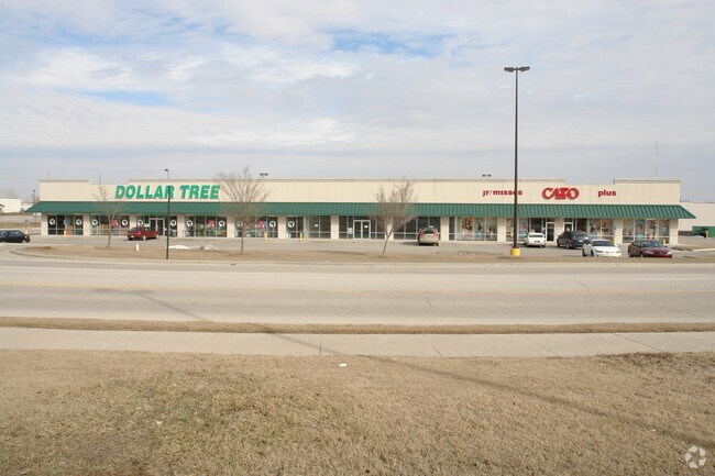

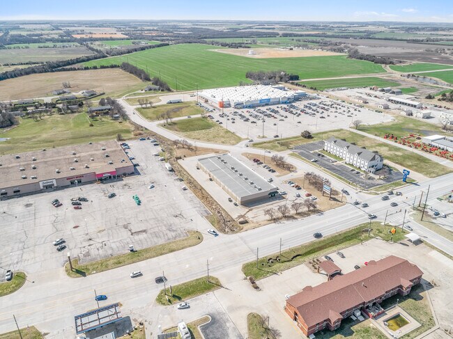
Property Detail
102 Peter Pan Rd
087-35-0-20-02-009.02-0
CHRISTINA COMM SUB, S35, T32, R15, ACRES 2.59, LOT 1 E OF PETER PAN RD;
Communitycenter
Montgomery
H160
Kansas
B and X Area of moderate flood hazard, usually the area between the limits of the 100-year and 500-year floods.
1
2025
2.59 AC
2025
Kansas Area
950500
Other Market Areas
21,840 SF
NEARBY LISTINGS FOR SALE OR LEASE
DEMOGRAPHICS near 102 Peter Pan Rd
1 mile
3 mile
5 mile
2025 Total Population
406
9,536
11,451
2030 Population
412
9,555
11,305
Pop Growth 2025-2030
+ 1.48%
+ 0.20%
(1.27%)
Average Age
42
41
41
2025 Total Households
168
4,014
4,751
HH Growth 2025-2030
+ 1.19%
+ 0.07%
(1.30%)
Median Household Inc
$56,249
$50,034
$53,765
Avg Household Size
2.40
2.30
2.30
2025 Avg HH Vehicles
2.00
2.00
2.00
Median Home Value
$145,000
$87,915
$102,180
Median Year Built
1963
1951
1956
Nearby Places
Map Layers
Map Styles
 Street
 Aerial
Layers
 Traffic
 Biking
Places
Listings with unknown addresses are not visible on the map
- Restaurants
- Banks
- Shops
- Fitness
- Groceries
SALE & LEASE HISTORY
LISTING DATE
SALE/LEASE

Oct 26, 2021
For Lease
Nearby Properties
Address
Land Use
TOTAL SIZE
Lot Size
Zoning
Address
Land Use
TOTAL SIZE
Lot Size
Zoning
146,130 SF
33.60 AC
Address
Land Use
TOTAL SIZE
Lot Size
Zoning
82,325 SF
63 AC
Address
Land Use
TOTAL SIZE
Lot Size
Zoning
32,616 SF
3.90 AC
Address
Land Use
TOTAL SIZE
Lot Size
Zoning
72,789 SF
56.42 AC
Address
Land Use
TOTAL SIZE
Lot Size
Zoning
60,853 SF
10.65 AC
Address
Land Use
TOTAL SIZE
Lot Size
Zoning
107,129 SF
2.77 AC
Address
Land Use
TOTAL SIZE
Lot Size
Zoning
192,500 SF
39.08 AC
PPRD
Address
Land Use
TOTAL SIZE
Lot Size
Zoning
19,014 SF
0.48 AC
Address
Land Use
TOTAL SIZE
Lot Size
Zoning
77,812 SF
0.97 AC
Address
Land Use
TOTAL SIZE
Lot Size
Zoning
17,638 SF
7.50 AC
PPRD
Address
Land Use
TOTAL SIZE
Lot Size
Zoning
27,392 SF
0.66 AC
Address
Land Use
TOTAL SIZE
Lot Size
Zoning
3,120 SF
2.02 AC
Address
Land Use
TOTAL SIZE
Lot Size
Zoning
49,708 SF
3.92 AC
Address
Land Use
TOTAL SIZE
Lot Size
Zoning
9,360 SF
0.99 AC
Address
Land Use
TOTAL SIZE
Lot Size
Zoning
40,421 SF
5.19 AC
H160
Address
Land Use
TOTAL SIZE
Lot Size
Zoning
11,647 SF
6.85 AC
H160
Address
Land Use
TOTAL SIZE
Lot Size
Zoning
7,131 SF
51 AC
Address
Land Use
TOTAL SIZE
Lot Size
Zoning
12,872 SF
0.51 AC
Address
Land Use
TOTAL SIZE
Lot Size
Zoning
25,919 SF
0.75 AC
Address
Land Use
TOTAL SIZE
Lot Size
Zoning
26,438 SF
0.52 AC
Address
Land Use
TOTAL SIZE
Lot Size
Zoning
7,455 SF
2.58 AC
Address
Land Use
TOTAL SIZE
Lot Size
Zoning
14,868 SF
2.81 AC
Address
Land Use
TOTAL SIZE
Lot Size
Zoning
14,667 SF
2.24 AC
Address
Land Use
TOTAL SIZE
Lot Size
Zoning
153,207 SF
19.19 AC
H160
Address
Land Use
TOTAL SIZE
Lot Size
Zoning
3,736 SF
2.01 AC
331
Address
Land Use
TOTAL SIZE
Lot Size
Zoning
26,932 SF
0.46 AC
Address
Land Use
TOTAL SIZE
Lot Size
Zoning
36,591 SF
0.72 AC
Address
Land Use
TOTAL SIZE
Lot Size
Zoning
13,604 SF
4.80 AC
Address
Land Use
TOTAL SIZE
Lot Size
Zoning
10,042 SF
0.39 AC
Address
Land Use
TOTAL SIZE
Lot Size
Zoning
17,669 SF
1.80 AC
The World's #1 Commercial Real Estate Marketplace
Connect with us
© 2026 CoStar Group
The information above has been obtained from sources believed reliable. While we do not doubt its accuracy we have not verified it and make no guarantee, warranty or representation about it. It is your responsibility to independently confirm its accuracy and completeness. Any projections, opinions, assumptions, or estimates used are for example only and do not represent the current or future performance of the property. The value of this transaction to you depends on tax and other factors which should be evaluated by your tax, financial, and legal advisors. You and your advisors should conduct a careful, independent investigation of the property to determine to your satisfaction the suitability of the property for your needs.