Property Record
102 Rock Barn Rd Ne, Conover, NC 28613
NEARBY LISTINGS FOR SALE OR LEASE
Property Detail
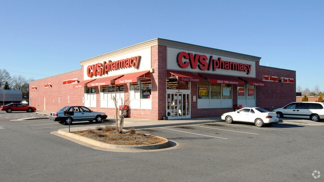
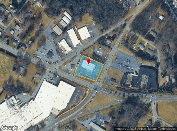
102 Rock Barn Rd Ne
Hickory-Lenoir-Morganton, NC
Carpenter Crossroads Dev
3741063853170000
LOT 1-3 PL 11-12
Drugstorepharmacycvswalgreens
Catawba
X
North Carolina
3710374100J
1-3
2024
1.20 AC
2025
Catawba County
010102
Charlotte
10,125 SF
DEMOGRAPHICS near 102 Rock Barn Rd Ne
1 Mile
3 Mile
5 Mile
2024 Total Population
4,436
19,269
44,794
2029 Population
4,624
20,140
46,798
Pop Growth 2024-2029
+ 4.24%
+ 4.52%
+ 4.47%
Average Age
44
41
40
2024 Total Households
1,863
7,777
17,657
HH Growth 2024-2029
+ 4.13%
+ 4.41%
+ 4.41%
Median Household Inc
$53,889
$53,050
$56,199
Avg Household Size
2.20
2.40
2.50
2024 Avg HH Vehicles
2.00
2.00
2.00
Median Home Value
$218,863
$179,624
$171,295
Median Year Built
1984
1984
1984
Nearby Places
Map Layers
Map Styles
 Street
 Aerial
- Restaurants
- Banks
- Shops
- Fitness
- Groceries
Nearby Properties
Address
Land Use
TOTAL SIZE
Lot Size
Zoning
Address
Land Use
TOTAL SIZE
Lot Size
Zoning
502,665 SF
53.28 AC
EM-1-CD
Address
Land Use
TOTAL SIZE
Lot Size
Zoning
7,684 SF
11.85 AC
R-20-CD
Address
Land Use
TOTAL SIZE
Lot Size
Zoning
157,777 SF
25.42 AC
M-1
Address
Land Use
TOTAL SIZE
Lot Size
Zoning
67,806 SF
27.40 AC
M-1
Address
Land Use
TOTAL SIZE
Lot Size
Zoning
82,274 SF
19.77 AC
M-1-CD
Address
Land Use
TOTAL SIZE
Lot Size
Zoning
217,586 SF
28.33 AC
CC-CD
Address
Land Use
TOTAL SIZE
Lot Size
Zoning
248,173 SF
53.73 AC
B-4
Address
Land Use
TOTAL SIZE
Lot Size
Zoning
398,044 SF
17.89 AC
M-1
Address
Land Use
TOTAL SIZE
Lot Size
Zoning
30.63 AC
R-20
Address
Land Use
TOTAL SIZE
Lot Size
Zoning
4,700 SF
34.87 AC
COI
Address
Land Use
TOTAL SIZE
Lot Size
Zoning
103,090 SF
36.13 AC
R-9
Address
Land Use
TOTAL SIZE
Lot Size
Zoning
150,498 SF
11.27 AC
M-1
Address
Land Use
TOTAL SIZE
Lot Size
Zoning
23,646 SF
79.60 AC
M-1
Address
Land Use
TOTAL SIZE
Lot Size
Zoning
9,064 SF
4.59 AC
B-2-CD
Address
Land Use
TOTAL SIZE
Lot Size
Zoning
283,942 SF
26.59 AC
M-1
Address
Land Use
TOTAL SIZE
Lot Size
Zoning
270,125 SF
19.98 AC
EM-1
Address
Land Use
TOTAL SIZE
Lot Size
Zoning
226,704 SF
24.60 AC
EM-1
Address
Land Use
TOTAL SIZE
Lot Size
Zoning
155,824 SF
27.77 AC
M-1
Address
Land Use
TOTAL SIZE
Lot Size
Zoning
67,085 SF
15.80 AC
PD-SC-M
Address
Land Use
TOTAL SIZE
Lot Size
Zoning
354,727 SF
28.03 AC
M-1
Address
Land Use
TOTAL SIZE
Lot Size
Zoning
213,422 SF
33.51 AC
M-1
Address
Land Use
TOTAL SIZE
Lot Size
Zoning
637,521 SF
87.22 AC
M-1
Address
Land Use
TOTAL SIZE
Lot Size
Zoning
7,680 SF
9.22 AC
PD-H
Address
Land Use
TOTAL SIZE
Lot Size
Zoning
20.90 AC
M-1
Address
Land Use
TOTAL SIZE
Lot Size
Zoning
318,757 SF
23.50 AC
M-1
Address
Land Use
TOTAL SIZE
Lot Size
Zoning
234,094 SF
15.22 AC
EM-1
Address
Land Use
TOTAL SIZE
Lot Size
Zoning
156,161 SF
17.22 AC
M-1
Address
Land Use
TOTAL SIZE
Lot Size
Zoning
206,696 SF
10.24 AC
M-1
Address
Land Use
TOTAL SIZE
Lot Size
Zoning
249,849 SF
20.99 AC
M-1
Address
Land Use
TOTAL SIZE
Lot Size
Zoning
36,254 SF
13.18 AC
M-1
The World's #1 Commercial Real Estate Marketplace
Connect with us
© 2025 CoStar Group
The information above has been obtained from sources believed reliable. While we do not doubt its accuracy we have not verified it and make no guarantee, warranty or representation about it. It is your responsibility to independently confirm its accuracy and completeness. Any projections, opinions, assumptions, or estimates used are for example only and do not represent the current or future performance of the property. The value of this transaction to you depends on tax and other factors which should be evaluated by your tax, financial, and legal advisors. You and your advisors should conduct a careful, independent investigation of the property to determine to your satisfaction the suitability of the property for your needs.