Property Record
102 Rolling Thunder Way, Carlin, NV 89822
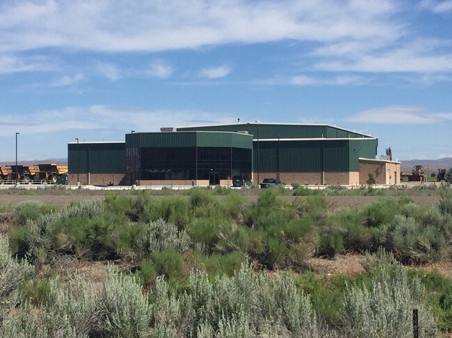

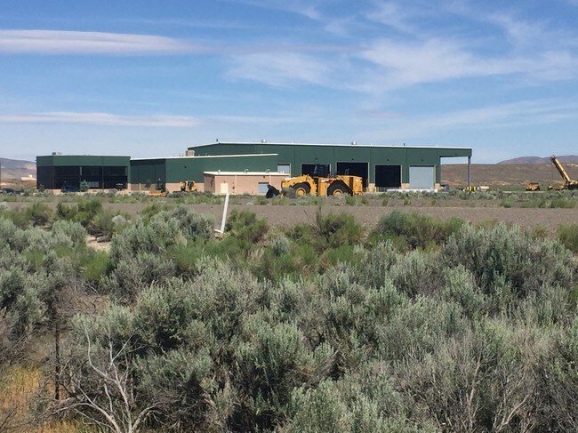
Property Detail
102 Rolling Thunder Way
002-300-002
ROLLING THUNDER WAY
Lightindustrial
Elko
RR&F
Nevada
A Areas with a 1% annual chance of flooding and a 26% chance of flooding over the life of a 30-year mortgage.
269.58 AC
2024
Carson City/Nevada Area
2025
Other Market Areas
951600
Elko, NV
49,848 SF
NEARBY LISTINGS FOR SALE OR LEASE
-
-
View all Carlin listings for sale on LoopNet.com
DEMOGRAPHICS near 102 Rolling Thunder Way
1 mile
3 mile
5 mile
2025 Total Population
0
1,661
1,691
2030 Population
0
1,586
1,614
Pop Growth 2025-2030
0.00%
(4.52%)
(4.55%)
Average Age
0
39
39
2025 Total Households
0
640
652
HH Growth 2025-2030
0.00%
(4.69%)
(4.75%)
Median Household Inc
$0
$63,113
$63,234
Avg Household Size
.00
2.40
2.40
2025 Avg HH Vehicles
.00
2.00
2.00
Median Home Value
$0
$223,295
$225,000
Median Year Built
0
1983
1983
Nearby Places
Map Layers
Map Styles
 Street
 Aerial
Layers
 Traffic
 Biking
Places
Listings with unknown addresses are not visible on the map
- Restaurants
- Banks
- Shops
- Fitness
- Groceries
SALE & LEASE HISTORY
LISTING DATE
SALE/LEASE

Sep 23, 2016
For Sale
Jun 30, 2017
For Sale
Jun 23, 2017
For Sale
Jun 20, 2017
For Sale
Jul 31, 2017
For Sale
Nearby Properties
Address
Land Use
TOTAL SIZE
Lot Size
Zoning
Address
Land Use
TOTAL SIZE
Lot Size
Zoning
15,632 SF
56.40 AC
MULT
Address
Land Use
TOTAL SIZE
Lot Size
Zoning
61,894 SF
10 AC
SCHOOL
Address
Land Use
TOTAL SIZE
Lot Size
Zoning
13,136 SF
641 AC
MULT
Address
Land Use
TOTAL SIZE
Lot Size
Zoning
28,286 SF
2.17 AC
TC
Address
Land Use
TOTAL SIZE
Lot Size
Zoning
15,532 SF
2.10 AC
COM
Address
Land Use
TOTAL SIZE
Lot Size
Zoning
22,356 SF
10 AC
LI
Address
Land Use
TOTAL SIZE
Lot Size
Zoning
8,347 SF
1.67 AC
TC
Address
Land Use
TOTAL SIZE
Lot Size
Zoning
12,480 SF
17.33 AC
LI
Address
Land Use
TOTAL SIZE
Lot Size
Zoning
6,125 SF
1.06 AC
COM
Address
Land Use
TOTAL SIZE
Lot Size
Zoning
5,041 SF
9.64 AC
RR&F
Address
Land Use
TOTAL SIZE
Lot Size
Zoning
8,928 SF
5.65 AC
LI
Address
Land Use
TOTAL SIZE
Lot Size
Zoning
10,856 SF
25.95 AC
LI
Address
Land Use
TOTAL SIZE
Lot Size
Zoning
9,400 SF
1.53 AC
MULT
Address
Land Use
TOTAL SIZE
Lot Size
Zoning
13,092.69 AC
Address
Land Use
TOTAL SIZE
Lot Size
Zoning
10,080 SF
2.64 AC
LI
Address
Land Use
TOTAL SIZE
Lot Size
Zoning
1,920 SF
14.79 AC
LI
Address
Land Use
TOTAL SIZE
Lot Size
Zoning
4,200 SF
5.50 AC
RR&F
Address
Land Use
TOTAL SIZE
Lot Size
Zoning
6,088 SF
1.20 AC
COM
Address
Land Use
TOTAL SIZE
Lot Size
Zoning
6,800 SF
10.93 AC
OPEN
Address
Land Use
TOTAL SIZE
Lot Size
Zoning
8,080 SF
0.78 AC
COM
Address
Land Use
TOTAL SIZE
Lot Size
Zoning
8,600 SF
8.14 AC
LI
Address
Land Use
TOTAL SIZE
Lot Size
Zoning
8,804 SF
0.69 AC
RMH3
Address
Land Use
TOTAL SIZE
Lot Size
Zoning
4,888 SF
1 AC
COM
Address
Land Use
TOTAL SIZE
Lot Size
Zoning
3,427 SF
0.57 AC
RMH2
Address
Land Use
TOTAL SIZE
Lot Size
Zoning
4,400 SF
1,598.82 AC
OS
Address
Land Use
TOTAL SIZE
Lot Size
Zoning
11,008 SF
4 AC
LI
Address
Land Use
TOTAL SIZE
Lot Size
Zoning
7,750 SF
1.38 AC
NR
Address
Land Use
TOTAL SIZE
Lot Size
Zoning
2,884 SF
0.59 AC
COM
The World's #1 Commercial Real Estate Marketplace
Connect with us
© 2026 CoStar Group
The information above has been obtained from sources believed reliable. While we do not doubt its accuracy we have not verified it and make no guarantee, warranty or representation about it. It is your responsibility to independently confirm its accuracy and completeness. Any projections, opinions, assumptions, or estimates used are for example only and do not represent the current or future performance of the property. The value of this transaction to you depends on tax and other factors which should be evaluated by your tax, financial, and legal advisors. You and your advisors should conduct a careful, independent investigation of the property to determine to your satisfaction the suitability of the property for your needs.