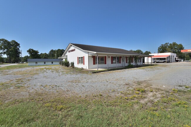
Property Record
102 S 2Nd St, Macclesfield, NC 27852
NEARBY LISTINGS FOR SALE OR LEASE
-
-
View all Macclesfield listings for sale on LoopNet.com
Property Detail
102 S 2Nd St
Rocky Mount, NC
S Section Ond St? No Add
3793-40-5654-00
102 S SECOND ST? NO ADDRESS PROVIDED BY MACCLESFIELD
Residentialacreage
Edgecombe
X
North Carolina
3720379300K
0.23 AC
2024
Rocky Mount/Wilson
2024
Other Market Areas
021600
DEMOGRAPHICS near 102 S 2Nd St
1 Mile
3 Mile
5 Mile
2024 Total Population
411
1,674
4,925
2029 Population
385
1,571
4,633
Pop Growth 2024-2029
(6.33%)
(6.15%)
(5.93%)
Average Age
44
43
43
2024 Total Households
176
707
2,012
HH Growth 2024-2029
(6.25%)
(6.08%)
(5.96%)
Median Household Inc
$63,281
$55,937
$49,637
Avg Household Size
2.30
2.40
2.40
2024 Avg HH Vehicles
2.00
3.00
2.00
Median Home Value
$138,461
$137,771
$121,221
Median Year Built
1979
1982
1982
Nearby Places
Map Layers
Map Styles
 Street
 Aerial
- Restaurants
- Banks
- Shops
- Fitness
- Groceries
PUBLIC TRANSPORTATION
AIRPORT
Pitt-Greenville
DRIVE
WALK
Distance
Pitt-Greenville
34 min
22.7 mi
Freight Ports
Port of Morehead City
DRIVE
WALK
Distance
Port of Morehead City
161 min
107.7 mi
SALE & LEASE HISTORY
LISTING DATE
SALE/LEASE

Sep 07, 2023
For Sale
Nearby Properties
Address
Land Use
TOTAL SIZE
Lot Size
Zoning
Address
Land Use
TOTAL SIZE
Lot Size
Zoning
14,448 SF
23.14 AC
Address
Land Use
TOTAL SIZE
Lot Size
Zoning
9,301 SF
1 AC
Address
Land Use
TOTAL SIZE
Lot Size
Zoning
8,830 SF
2.67 AC
Address
Land Use
TOTAL SIZE
Lot Size
Zoning
Address
Land Use
TOTAL SIZE
Lot Size
Zoning
6,520 SF
172.01 AC
Address
Land Use
TOTAL SIZE
Lot Size
Zoning
1,602 SF
286.89 AC
Address
Land Use
TOTAL SIZE
Lot Size
Zoning
3,060 SF
1.36 AC
Address
Land Use
TOTAL SIZE
Lot Size
Zoning
7,094 SF
6.16 AC
Address
Land Use
TOTAL SIZE
Lot Size
Zoning
2,242 SF
10.02 AC
Address
Land Use
TOTAL SIZE
Lot Size
Zoning
285.93 AC
Address
Land Use
TOTAL SIZE
Lot Size
Zoning
2,598 SF
24.78 AC
Address
Land Use
TOTAL SIZE
Lot Size
Zoning
6,092 SF
1.38 AC
Address
Land Use
TOTAL SIZE
Lot Size
Zoning
3,040 SF
26.56 AC
Address
Land Use
TOTAL SIZE
Lot Size
Zoning
7,487 SF
0.72 AC
Address
Land Use
TOTAL SIZE
Lot Size
Zoning
203.26 AC
Address
Land Use
TOTAL SIZE
Lot Size
Zoning
2,833 SF
12.03 AC
Address
Land Use
TOTAL SIZE
Lot Size
Zoning
2,626 SF
3.48 AC
Address
Land Use
TOTAL SIZE
Lot Size
Zoning
2,135 SF
17.68 AC
Address
Land Use
TOTAL SIZE
Lot Size
Zoning
169.52 AC
Address
Land Use
TOTAL SIZE
Lot Size
Zoning
2,248 SF
175.65 AC
Address
Land Use
TOTAL SIZE
Lot Size
Zoning
1,841 SF
94.36 AC
Address
Land Use
TOTAL SIZE
Lot Size
Zoning
2,787 SF
23.75 AC
Address
Land Use
TOTAL SIZE
Lot Size
Zoning
235.04 AC
Address
Land Use
TOTAL SIZE
Lot Size
Zoning
174.85 AC
Address
Land Use
TOTAL SIZE
Lot Size
Zoning
174.85 AC
Address
Land Use
TOTAL SIZE
Lot Size
Zoning
3,076 SF
19.02 AC
Address
Land Use
TOTAL SIZE
Lot Size
Zoning
173.83 AC
Address
Land Use
TOTAL SIZE
Lot Size
Zoning
2,057 SF
6.10 AC
Address
Land Use
TOTAL SIZE
Lot Size
Zoning
1,536 SF
149.74 AC
Address
Land Use
TOTAL SIZE
Lot Size
Zoning
2,443 SF
1.04 AC
The World's #1 Commercial Real Estate Marketplace
Connect with us
© 2025 CoStar Group
The information above has been obtained from sources believed reliable. While we do not doubt its accuracy we have not verified it and make no guarantee, warranty or representation about it. It is your responsibility to independently confirm its accuracy and completeness. Any projections, opinions, assumptions, or estimates used are for example only and do not represent the current or future performance of the property. The value of this transaction to you depends on tax and other factors which should be evaluated by your tax, financial, and legal advisors. You and your advisors should conduct a careful, independent investigation of the property to determine to your satisfaction the suitability of the property for your needs.