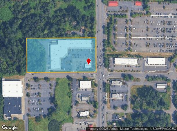
Property Record
102 W Stuart Rd, Bellingham, WA 98226
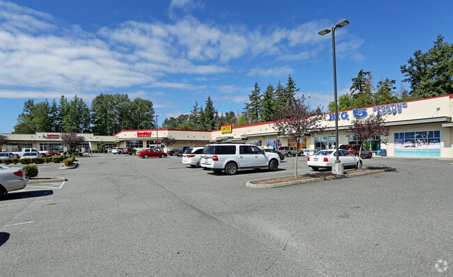
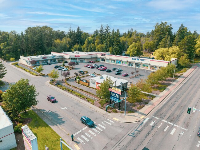
This Property Is For Sale
NEARBY LISTINGS FOR SALE OR LEASE
Property Detail
102 W Stuart Rd
Bellingham, WA
Bakerview Add To Bellingham
380212-535450-0000
BAKERVIEW ADD TO BELLINGHAM-LOTS 15-16 BLK 52-EXC PTN TO STATE FOR HWY DESC AF 1551306-1557305-EXC OIL-GAS-MIN RTS AS REC IN VOL 280-D-119 ON LOT 16-SUBJ TO COVENANT TO BIND PROPERTIES AF 2080304785
Stripcommercialcenter
Whatcom
X
Washington
53073C1211E
15-16
2024
4.26 AC
2024
Bellingham/Northwest
000203
Other Market Areas
44,937 SF
DEMOGRAPHICS near 102 W Stuart Rd
1 Mile
3 Mile
5 Mile
2024 Total Population
8,660
40,517
93,592
2029 Population
9,142
42,398
97,715
Pop Growth 2024-2029
+ 5.57%
+ 4.64%
+ 4.41%
Average Age
42
40
39
2024 Total Households
4,077
17,977
38,991
HH Growth 2024-2029
+ 5.81%
+ 4.73%
+ 4.56%
Median Household Inc
$55,419
$61,385
$65,114
Avg Household Size
2.10
2.20
2.30
2024 Avg HH Vehicles
1.00
2.00
2.00
Median Home Value
$409,562
$486,801
$561,185
Median Year Built
2000
1990
1986
Nearby Places
- Restaurants
- Banks
- Shops
- Fitness
- Groceries
PUBLIC TRANSPORTATION
COMMUTER RAIL
Bellingham Amtrak Station (Amtrak Cascades - Amtrak)
DRIVE
WALK
Distance
Bellingham Amtrak Station (Amtrak Cascades - Amtrak)
13 min
8.9 mi
AIRPORT
Bellingham International
DRIVE
WALK
Distance
Bellingham International
8 min
3.9 mi
Abbotsford International
DRIVE
WALK
Distance
Abbotsford International
42 min
23.4 mi
Freight Ports
Port of Bellingham, WA
DRIVE
WALK
Distance
Port of Bellingham, WA
9 min
4.5 mi
Nearby Properties
Address
Land Use
TOTAL SIZE
Lot Size
Zoning
Address
Land Use
TOTAL SIZE
Lot Size
Zoning
507,750 SF
15.05 AC
IN
Address
Land Use
TOTAL SIZE
Lot Size
Zoning
111,507 SF
845.26 AC
AO
Address
Land Use
TOTAL SIZE
Lot Size
Zoning
330,497 SF
30.17 AC
P
Address
Land Use
TOTAL SIZE
Lot Size
Zoning
46,850 SF
129.61 AC
RMPLAN
Address
Land Use
TOTAL SIZE
Lot Size
Zoning
292,744 SF
9.14 AC
LIL
Address
Land Use
TOTAL SIZE
Lot Size
Zoning
177,740 SF
7.42 AC
PC
Address
Land Use
TOTAL SIZE
Lot Size
Zoning
239,925 SF
17.46 AC
PC
Address
Land Use
TOTAL SIZE
Lot Size
Zoning
112,423 SF
3.23 AC
RS
Address
Land Use
TOTAL SIZE
Lot Size
Zoning
89,174 SF
3.74 AC
PCLI
Address
Land Use
TOTAL SIZE
Lot Size
Zoning
218,295 SF
13.22 AC
PRM2.5
Address
Land Use
TOTAL SIZE
Lot Size
Zoning
239,299 SF
7.73 AC
PRM2.5
Address
Land Use
TOTAL SIZE
Lot Size
Zoning
459,793 SF
25.47 AC
PREC
Address
Land Use
TOTAL SIZE
Lot Size
Zoning
152,381 SF
6.05 AC
PC
Address
Land Use
TOTAL SIZE
Lot Size
Zoning
159,238 SF
1.54 AC
PICR
Address
Land Use
TOTAL SIZE
Lot Size
Zoning
153,456 SF
5.86 AC
LIL
Address
Land Use
TOTAL SIZE
Lot Size
Zoning
95,263 SF
2.84 AC
PIN
Address
Land Use
TOTAL SIZE
Lot Size
Zoning
162,443 SF
8.01 AC
PI
Address
Land Use
TOTAL SIZE
Lot Size
Zoning
84,006 SF
16.20 AC
PICR4
Address
Land Use
TOTAL SIZE
Lot Size
Zoning
146,187 SF
6.44 AC
PC
Address
Land Use
TOTAL SIZE
Lot Size
Zoning
158,200 SF
1.34 AC
PICR
Address
Land Use
TOTAL SIZE
Lot Size
Zoning
168,279 SF
2.50 AC
PCM2.5
Address
Land Use
TOTAL SIZE
Lot Size
Zoning
178,131 SF
7.42 AC
URM18
Address
Land Use
TOTAL SIZE
Lot Size
Zoning
143,818 SF
6.75 AC
RM2.0
Address
Land Use
TOTAL SIZE
Lot Size
Zoning
166,448 SF
13.97 AC
PIC
Address
Land Use
TOTAL SIZE
Lot Size
Zoning
229,913 SF
15.28 AC
PI
Address
Land Use
TOTAL SIZE
Lot Size
Zoning
147,805 SF
8.92 AC
IN
Address
Land Use
TOTAL SIZE
Lot Size
Zoning
88,091 SF
4.90 AC
PICR
Address
Land Use
TOTAL SIZE
Lot Size
Zoning
88,272 SF
5.86 AC
PI
Address
Land Use
TOTAL SIZE
Lot Size
Zoning
104,251 SF
14.10 AC
PU
Address
Land Use
TOTAL SIZE
Lot Size
Zoning
150,921 SF
15.15 AC
PLI
The World's #1 Commercial Real Estate Marketplace
Connect with us
© 2025 CoStar Group
The information above has been obtained from sources believed reliable. While we do not doubt its accuracy we have not verified it and make no guarantee, warranty or representation about it. It is your responsibility to independently confirm its accuracy and completeness. Any projections, opinions, assumptions, or estimates used are for example only and do not represent the current or future performance of the property. The value of this transaction to you depends on tax and other factors which should be evaluated by your tax, financial, and legal advisors. You and your advisors should conduct a careful, independent investigation of the property to determine to your satisfaction the suitability of the property for your needs.