Property Record
102 Vantage Point Dr, West Columbia, SC 29172
NEARBY LISTINGS FOR SALE OR LEASE
Property Detail
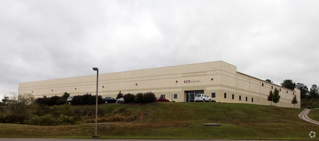
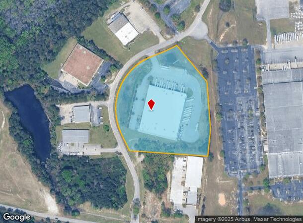
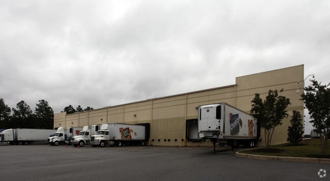
102 Vantage Point Dr
Columbia, SC
Overlook Park
006897-01-036
LOTS 107 & 108
Warehouse
Lexington
X
South Carolina
45063C0287J
107-108
2025
7.91 AC
2024
Cayce/West Columbia
020604
Columbia
79,800 SF
DEMOGRAPHICS near 102 Vantage Point Dr
1 Mile
3 Mile
5 Mile
2024 Total Population
798
15,095
71,521
2029 Population
862
16,526
76,741
Pop Growth 2024-2029
+ 8.02%
+ 9.48%
+ 7.30%
Average Age
41
40
36
2024 Total Households
368
6,560
29,717
HH Growth 2024-2029
+ 8.15%
+ 9.57%
+ 7.88%
Median Household Inc
$77,239
$54,400
$47,806
Avg Household Size
2.20
2.20
2.10
2024 Avg HH Vehicles
2.00
2.00
2.00
Median Home Value
$222,692
$135,427
$152,667
Median Year Built
1990
1973
1978
Nearby Places
Map Layers
Map Styles
 Street
 Aerial
- Restaurants
- Banks
- Shops
- Fitness
- Groceries
PUBLIC TRANSPORTATION
COMMUTER RAIL
Columbia Amtrak Station (Silver Star - Amtrak)
DRIVE
WALK
Distance
Columbia Amtrak Station (Silver Star - Amtrak)
16 min
7.5 mi
AIRPORT
Columbia Metro
DRIVE
WALK
Distance
Columbia Metro
20 min
7.5 mi
Freight Ports
North Charleston Terminal
DRIVE
WALK
Distance
North Charleston Terminal
116 min
100.1 mi
Nearby Properties
Address
Land Use
TOTAL SIZE
Lot Size
Zoning
Address
Land Use
TOTAL SIZE
Lot Size
Zoning
1,253,820 SF
87.15 AC
Address
Land Use
TOTAL SIZE
Lot Size
Zoning
466,400 SF
52.42 AC
ID
Address
Land Use
TOTAL SIZE
Lot Size
Zoning
16,112 SF
124.65 AC
RU
Address
Land Use
TOTAL SIZE
Lot Size
Zoning
4,586 SF
19.15 AC
Address
Land Use
TOTAL SIZE
Lot Size
Zoning
1,218 SF
8.99 AC
RG
Address
Land Use
TOTAL SIZE
Lot Size
Zoning
297,500 SF
20.26 AC
ID
Address
Land Use
TOTAL SIZE
Lot Size
Zoning
8,118 SF
10.98 AC
RG
Address
Land Use
TOTAL SIZE
Lot Size
Zoning
180,000 SF
27.57 AC
ID
Address
Land Use
TOTAL SIZE
Lot Size
Zoning
10,304 SF
11.89 AC
R1
Address
Land Use
TOTAL SIZE
Lot Size
Zoning
181,440 SF
10.69 AC
ID
Address
Land Use
TOTAL SIZE
Lot Size
Zoning
9,800 SF
13.52 AC
ID
Address
Land Use
TOTAL SIZE
Lot Size
Zoning
5,502 SF
16.15 AC
ID
Address
Land Use
TOTAL SIZE
Lot Size
Zoning
200,000 SF
10.58 AC
ID
Address
Land Use
TOTAL SIZE
Lot Size
Zoning
61,012 SF
5.34 AC
Address
Land Use
TOTAL SIZE
Lot Size
Zoning
200,000 SF
9.66 AC
ID
Address
Land Use
TOTAL SIZE
Lot Size
Zoning
180,000 SF
12.48 AC
ID
Address
Land Use
TOTAL SIZE
Lot Size
Zoning
279,568 SF
11.38 AC
ID
Address
Land Use
TOTAL SIZE
Lot Size
Zoning
44,352 SF
7.55 AC
D1
Address
Land Use
TOTAL SIZE
Lot Size
Zoning
254,399 SF
49.79 AC
ID
Address
Land Use
TOTAL SIZE
Lot Size
Zoning
202,029 SF
21.13 AC
ID
Address
Land Use
TOTAL SIZE
Lot Size
Zoning
35.70 AC
Address
Land Use
TOTAL SIZE
Lot Size
Zoning
215,770 SF
24.51 AC
Address
Land Use
TOTAL SIZE
Lot Size
Zoning
50,400 SF
11 AC
ID
Address
Land Use
TOTAL SIZE
Lot Size
Zoning
1,360 SF
16.41 AC
RU
Address
Land Use
TOTAL SIZE
Lot Size
Zoning
92.08 AC
Address
Land Use
TOTAL SIZE
Lot Size
Zoning
104,000 SF
18.53 AC
Address
Land Use
TOTAL SIZE
Lot Size
Zoning
120,000 SF
18.44 AC
ID
Address
Land Use
TOTAL SIZE
Lot Size
Zoning
Address
Land Use
TOTAL SIZE
Lot Size
Zoning
53.82 AC
Address
Land Use
TOTAL SIZE
Lot Size
Zoning
14,602 SF
2.41 AC
C2
The World's #1 Commercial Real Estate Marketplace
Connect with us
© 2026 CoStar Group
The information above has been obtained from sources believed reliable. While we do not doubt its accuracy we have not verified it and make no guarantee, warranty or representation about it. It is your responsibility to independently confirm its accuracy and completeness. Any projections, opinions, assumptions, or estimates used are for example only and do not represent the current or future performance of the property. The value of this transaction to you depends on tax and other factors which should be evaluated by your tax, financial, and legal advisors. You and your advisors should conduct a careful, independent investigation of the property to determine to your satisfaction the suitability of the property for your needs.