Property Record
102 Victory Hwy, Painted Post, NY 14870

NEARBY LISTINGS FOR SALE OR LEASE
-
-
View all Painted Post listings for lease on LoopNet.com
Property Detail
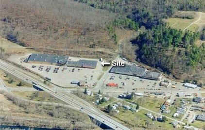
102 Victory Hwy
Corning, NY
CREATION DATE: 960924; UPDATE DATE: 970819
464289-280-000-0001-015-100
Steuben
Communitycenter
New York
2025
15.100
2024
11.40 AC
962301
Ithaca/Elmira
111,500 SF
Other Market Areas
DEMOGRAPHICS near 102 Victory Hwy
1 Mile
3 Mile
5 Mile
2024 Total Population
1,451
13,577
22,196
2029 Population
1,408
13,260
21,666
Pop Growth 2024-2029
(2.96%)
(2.33%)
(2.39%)
Average Age
43
41
41
2024 Total Households
685
6,074
9,878
HH Growth 2024-2029
(3.07%)
(2.40%)
(2.46%)
Median Household Inc
$59,666
$65,119
$67,423
Avg Household Size
2.10
2.20
2.20
2024 Avg HH Vehicles
2.00
2.00
2.00
Median Home Value
$118,116
$146,175
$152,752
Median Year Built
1956
1959
1957
Nearby Places
Map Layers
Map Styles
 Street
 Aerial
- Restaurants
- Banks
- Shops
- Fitness
- Groceries
PUBLIC TRANSPORTATION
AIRPORT
Elmira/Corning Regional
DRIVE
WALK
Distance
Elmira/Corning Regional
25 min
19.3 mi
Freight Ports
Albany, NY Port
DRIVE
WALK
Distance
Albany, NY Port
262 min
221.0 mi
SALE & LEASE HISTORY
LISTING DATE
SALE/LEASE

Sep 25, 2016
For Lease
Nearby Properties
Address
Land Use
TOTAL SIZE
Lot Size
Zoning
Address
Land Use
TOTAL SIZE
Lot Size
Zoning
52,288 SF
9.50 AC
BD
Address
Land Use
TOTAL SIZE
Lot Size
Zoning
Address
Land Use
TOTAL SIZE
Lot Size
Zoning
406.35 AC
Address
Land Use
TOTAL SIZE
Lot Size
Zoning
192,620 SF
31.50 AC
05 - COMME
Address
Land Use
TOTAL SIZE
Lot Size
Zoning
103,000 SF
14.16 AC
07
Address
Land Use
TOTAL SIZE
Lot Size
Zoning
150,000 SF
17.94 AC
05
Address
Land Use
TOTAL SIZE
Lot Size
Zoning
17,892 SF
217.66 AC
COMM
Address
Land Use
TOTAL SIZE
Lot Size
Zoning
2,800 SF
27.97 AC
Address
Land Use
TOTAL SIZE
Lot Size
Zoning
81,728 SF
4.03 AC
BD
Address
Land Use
TOTAL SIZE
Lot Size
Zoning
69.90 AC
Address
Land Use
TOTAL SIZE
Lot Size
Zoning
55,000 SF
4.86 AC
07 - MIXED
Address
Land Use
TOTAL SIZE
Lot Size
Zoning
97,110 SF
13.31 AC
C
Address
Land Use
TOTAL SIZE
Lot Size
Zoning
82,123 SF
1.35 AC
C
Address
Land Use
TOTAL SIZE
Lot Size
Zoning
43,869 SF
5.02 AC
BD
Address
Land Use
TOTAL SIZE
Lot Size
Zoning
8,546 SF
31.88 AC
07 - MIXED
Address
Land Use
TOTAL SIZE
Lot Size
Zoning
48,040 SF
12.11 AC
BD
Address
Land Use
TOTAL SIZE
Lot Size
Zoning
20.37 AC
07 - MIXED
Address
Land Use
TOTAL SIZE
Lot Size
Zoning
46,800 SF
6.39 AC
07 - MIXED
Address
Land Use
TOTAL SIZE
Lot Size
Zoning
2.35 AC
Address
Land Use
TOTAL SIZE
Lot Size
Zoning
242,379 SF
4.30 AC
BD
Address
Land Use
TOTAL SIZE
Lot Size
Zoning
94,984 SF
11.62 AC
Address
Land Use
TOTAL SIZE
Lot Size
Zoning
55,981 SF
8 AC
05 - COMME
Address
Land Use
TOTAL SIZE
Lot Size
Zoning
40,000 SF
1.84 AC
CONF
Address
Land Use
TOTAL SIZE
Lot Size
Zoning
22.80 AC
05 - COMME
Address
Land Use
TOTAL SIZE
Lot Size
Zoning
28 AC
CL
Address
Land Use
TOTAL SIZE
Lot Size
Zoning
73,310 SF
1.30 AC
07 - MIXED
Address
Land Use
TOTAL SIZE
Lot Size
Zoning
6,112 SF
11.16 AC
MR
Address
Land Use
TOTAL SIZE
Lot Size
Zoning
4.90 AC
Address
Land Use
TOTAL SIZE
Lot Size
Zoning
7,808 SF
2.28 AC
MR
Address
Land Use
TOTAL SIZE
Lot Size
Zoning
7,992 SF
1.96 AC
MR
The World's #1 Commercial Real Estate Marketplace
Connect with us
© 2025 CoStar Group
The information above has been obtained from sources believed reliable. While we do not doubt its accuracy we have not verified it and make no guarantee, warranty or representation about it. It is your responsibility to independently confirm its accuracy and completeness. Any projections, opinions, assumptions, or estimates used are for example only and do not represent the current or future performance of the property. The value of this transaction to you depends on tax and other factors which should be evaluated by your tax, financial, and legal advisors. You and your advisors should conduct a careful, independent investigation of the property to determine to your satisfaction the suitability of the property for your needs.