Property Record
102 W 8Th St, Freeport, TX 77541
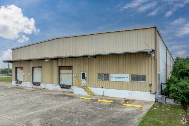

Property Detail
102 W 8Th St
Houston-Pasadena-The Woodlands, TX
FREEPORT BLK 39 LOT 5TO20 BLK 40 LOT 5TO16
4200-0429-000
Brazoria
Commercialnec
Texas
B and X Area of moderate flood hazard, usually the area between the limits of the 100-year and 500-year floods.
5to16
2024
3.88 AC
2025
South Hwy 35
664400
Houston
30,000 SF
NEARBY LISTINGS FOR SALE OR LEASE
DEMOGRAPHICS near 102 W 8Th St
1 mile
3 mile
5 mile
2025 Total Population
4,184
13,213
17,614
2030 Population
4,702
14,816
19,996
Pop Growth 2025-2030
+ 12.38%
+ 12.13%
+ 13.52%
Average Age
36
36
39
2025 Total Households
1,370
4,510
6,487
HH Growth 2025-2030
+ 12.77%
+ 12.48%
+ 14.27%
Median Household Inc
$37,029
$48,068
$53,243
Avg Household Size
3.00
2.90
2.70
2025 Avg HH Vehicles
2.00
2.00
2.00
Median Home Value
$166,592
$150,913
$191,399
Median Year Built
1970
1976
1978
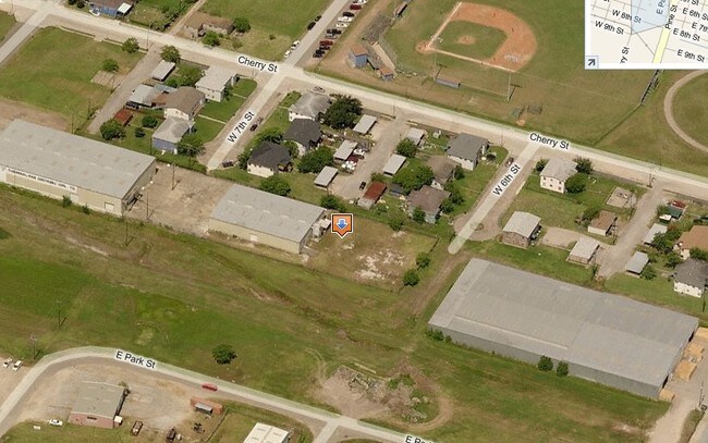
Nearby Places
Map Layers
Map Styles
 Street
 Aerial
Layers
 Traffic
 Biking
Places
Listings with unknown addresses are not visible on the map
- Restaurants
- Banks
- Shops
- Fitness
- Groceries
SALE & LEASE HISTORY
LISTING DATE
SALE/LEASE

Sep 18, 2023
For Sale
Jun 27, 2023
For Lease
Jun 22, 2023
For Lease
Jun 22, 2023
For Lease
Nearby Properties
Address
Land Use
TOTAL SIZE
Lot Size
Zoning
Address
Land Use
TOTAL SIZE
Lot Size
Zoning
Address
Land Use
TOTAL SIZE
Lot Size
Zoning
Address
Land Use
TOTAL SIZE
Lot Size
Zoning
Address
Land Use
TOTAL SIZE
Lot Size
Zoning
Address
Land Use
TOTAL SIZE
Lot Size
Zoning
Address
Land Use
TOTAL SIZE
Lot Size
Zoning
Address
Land Use
TOTAL SIZE
Lot Size
Zoning
320,260 SF
31.88 AC
Address
Land Use
TOTAL SIZE
Lot Size
Zoning
33.09 AC
0050
Address
Land Use
TOTAL SIZE
Lot Size
Zoning
Address
Land Use
TOTAL SIZE
Lot Size
Zoning
61.70 AC
Address
Land Use
TOTAL SIZE
Lot Size
Zoning
Address
Land Use
TOTAL SIZE
Lot Size
Zoning
Address
Land Use
TOTAL SIZE
Lot Size
Zoning
Address
Land Use
TOTAL SIZE
Lot Size
Zoning
Address
Land Use
TOTAL SIZE
Lot Size
Zoning
242.03 AC
0275
Address
Land Use
TOTAL SIZE
Lot Size
Zoning
Address
Land Use
TOTAL SIZE
Lot Size
Zoning
4.27 AC
0170
Address
Land Use
TOTAL SIZE
Lot Size
Zoning
188,497 SF
14.79 AC
1135
Address
Land Use
TOTAL SIZE
Lot Size
Zoning
94,933 SF
18.16 AC
0150
Address
Land Use
TOTAL SIZE
Lot Size
Zoning
122,989 SF
22.98 AC
0211
Address
Land Use
TOTAL SIZE
Lot Size
Zoning
128,282 SF
4.39 AC
0001
Address
Land Use
TOTAL SIZE
Lot Size
Zoning
24.81 AC
0031
Address
Land Use
TOTAL SIZE
Lot Size
Zoning
48,773 SF
Address
Land Use
TOTAL SIZE
Lot Size
Zoning
1.75 AC
Address
Land Use
TOTAL SIZE
Lot Size
Zoning
124,367 SF
6.17 AC
Address
Land Use
TOTAL SIZE
Lot Size
Zoning
15.78 AC
0130
Address
Land Use
TOTAL SIZE
Lot Size
Zoning
67,270 SF
6.12 AC
Address
Land Use
TOTAL SIZE
Lot Size
Zoning
Address
Land Use
TOTAL SIZE
Lot Size
Zoning
129,934 SF
10.96 AC
0006
Address
Land Use
TOTAL SIZE
Lot Size
Zoning
83,532 SF
3.71 AC
The World's #1 Commercial Real Estate Marketplace
Connect with us
© 2026 CoStar Group
The information above has been obtained from sources believed reliable. While we do not doubt its accuracy we have not verified it and make no guarantee, warranty or representation about it. It is your responsibility to independently confirm its accuracy and completeness. Any projections, opinions, assumptions, or estimates used are for example only and do not represent the current or future performance of the property. The value of this transaction to you depends on tax and other factors which should be evaluated by your tax, financial, and legal advisors. You and your advisors should conduct a careful, independent investigation of the property to determine to your satisfaction the suitability of the property for your needs.