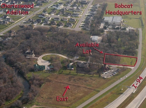
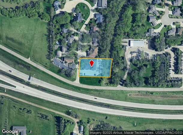
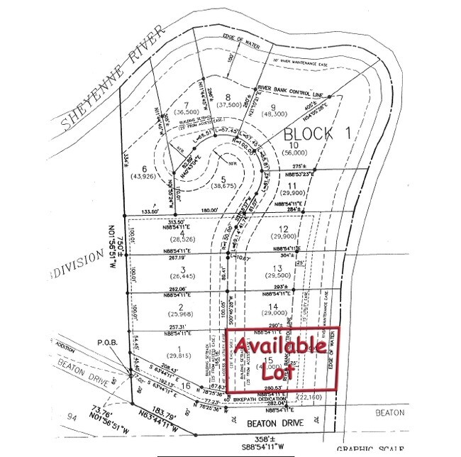
Property Record
102 W Beaton Dr, West Fargo, ND 58078
NEARBY LISTINGS FOR SALE OR LEASE
Property Detail
102 W Beaton Dr
Fargo, ND-MN
Oak
02-1490-00150-000
LOT: 15 BLOCK: 1 ADDITION: OAKWOOD BEND 1ST ADDITION ADDITIONAL: OAKWOOD BEND 1ST LT 15 BLK 1 **ANNEXED 2002
Realpropertynec
Cass
A
North Dakota
38017C0757G
15
2024
1.05 AC
2024
Fargo
010205
Other Market Areas
8,204 SF
DEMOGRAPHICS near 102 W Beaton Dr
1 Mile
3 Mile
5 Mile
2024 Total Population
9,698
72,419
129,702
2029 Population
10,496
77,882
138,995
Pop Growth 2024-2029
+ 8.23%
+ 7.54%
+ 7.16%
Average Age
36
34
35
2024 Total Households
3,964
31,126
55,276
HH Growth 2024-2029
+ 8.83%
+ 7.98%
+ 7.71%
Median Household Inc
$92,080
$71,508
$68,146
Avg Household Size
2.40
2.30
2.20
2024 Avg HH Vehicles
2.00
2.00
2.00
Median Home Value
$321,767
$270,758
$259,083
Median Year Built
2010
2005
1999
Nearby Places
Map Layers
Map Styles
 Street
 Aerial
- Restaurants
- Banks
- Shops
- Fitness
- Groceries
PUBLIC TRANSPORTATION
COMMUTER RAIL
DRIVE
WALK
Distance
17 min
8.5 mi
AIRPORT
Hector International
DRIVE
WALK
Distance
Hector International
21 min
10.9 mi
Nearby Properties
Address
Land Use
TOTAL SIZE
Lot Size
Zoning
Address
Land Use
TOTAL SIZE
Lot Size
Zoning
408,617 SF
9.33 AC
GC
Address
Land Use
TOTAL SIZE
Lot Size
Zoning
Address
Land Use
TOTAL SIZE
Lot Size
Zoning
418,024 SF
10.88 AC
Address
Land Use
TOTAL SIZE
Lot Size
Zoning
230,272 SF
21.77 AC
GC
Address
Land Use
TOTAL SIZE
Lot Size
Zoning
Address
Land Use
TOTAL SIZE
Lot Size
Zoning
Address
Land Use
TOTAL SIZE
Lot Size
Zoning
Address
Land Use
TOTAL SIZE
Lot Size
Zoning
163,195 SF
11.95 AC
GC
Address
Land Use
TOTAL SIZE
Lot Size
Zoning
Address
Land Use
TOTAL SIZE
Lot Size
Zoning
131,309 SF
6.62 AC
GC
Address
Land Use
TOTAL SIZE
Lot Size
Zoning
34,100 SF
1.46 AC
MR3
Address
Land Use
TOTAL SIZE
Lot Size
Zoning
Address
Land Use
TOTAL SIZE
Lot Size
Zoning
9,279 SF
8.33 AC
MR1
Address
Land Use
TOTAL SIZE
Lot Size
Zoning
45.33 AC
GC
Address
Land Use
TOTAL SIZE
Lot Size
Zoning
48,300 SF
2.33 AC
MR3
Address
Land Use
TOTAL SIZE
Lot Size
Zoning
30,240 SF
1.54 AC
MR2
Address
Land Use
TOTAL SIZE
Lot Size
Zoning
Address
Land Use
TOTAL SIZE
Lot Size
Zoning
73,907 SF
3.41 AC
MR3
Address
Land Use
TOTAL SIZE
Lot Size
Zoning
152,509 SF
18.14 AC
Address
Land Use
TOTAL SIZE
Lot Size
Zoning
146,131 SF
15.67 AC
GO
Address
Land Use
TOTAL SIZE
Lot Size
Zoning
46,271 SF
2.06 AC
MR3
Address
Land Use
TOTAL SIZE
Lot Size
Zoning
152,918 SF
5.38 AC
Address
Land Use
TOTAL SIZE
Lot Size
Zoning
54,927 SF
8.45 AC
Address
Land Use
TOTAL SIZE
Lot Size
Zoning
123,777 SF
1.90 AC
Address
Land Use
TOTAL SIZE
Lot Size
Zoning
41,046 SF
11.90 AC
Address
Land Use
TOTAL SIZE
Lot Size
Zoning
41,046 SF
11.78 AC
Address
Land Use
TOTAL SIZE
Lot Size
Zoning
104,817 SF
13.93 AC
GC
Address
Land Use
TOTAL SIZE
Lot Size
Zoning
794,266 SF
36.84 AC
GC
Address
Land Use
TOTAL SIZE
Lot Size
Zoning
190,588 SF
6.32 AC
Address
Land Use
TOTAL SIZE
Lot Size
Zoning
The World's #1 Commercial Real Estate Marketplace
Connect with us
© 2025 CoStar Group
The information above has been obtained from sources believed reliable. While we do not doubt its accuracy we have not verified it and make no guarantee, warranty or representation about it. It is your responsibility to independently confirm its accuracy and completeness. Any projections, opinions, assumptions, or estimates used are for example only and do not represent the current or future performance of the property. The value of this transaction to you depends on tax and other factors which should be evaluated by your tax, financial, and legal advisors. You and your advisors should conduct a careful, independent investigation of the property to determine to your satisfaction the suitability of the property for your needs.