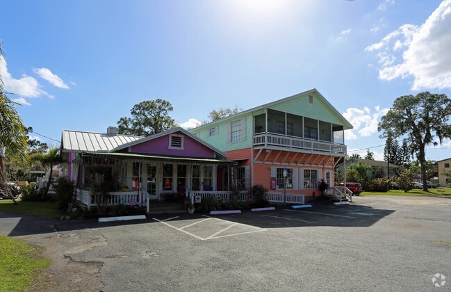
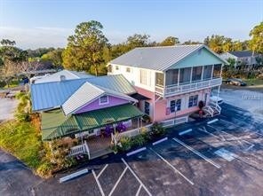
Property Record
102 W Shell Point Rd, Ruskin, FL 33570

Property Detail
102 W Shell Point Rd
U-07-32-19-1V5-000000-00091.0
RUSKIN CITY MAP OF LOT 91
Storebuilding
Hillsborough
PD
Florida
AE The base floodplain where base flood elevations are provided. AE Zones are now used on new format FIRMs instead of A1-A30 Zones.
91
2024
0.28 AC
2025
Southeast Hillsborough
014108
Tampa/St Petersburg
4,594 SF
Tampa-St. Petersburg-Clearwater, FL
NEARBY LISTINGS FOR SALE OR LEASE
DEMOGRAPHICS near 102 W Shell Point Rd
1 mile
3 mile
5 mile
2025 Total Population
7,453
43,727
86,219
2030 Population
8,196
48,389
95,470
Pop Growth 2025-2030
+ 9.97%
+ 10.66%
+ 10.73%
Average Age
38
40
47
2025 Total Households
2,546
15,481
35,116
HH Growth 2025-2030
+ 10.25%
+ 11.01%
+ 10.94%
Median Household Inc
$83,352
$82,915
$79,063
Avg Household Size
2.90
2.80
2.40
2025 Avg HH Vehicles
2.00
2.00
2.00
Median Home Value
$382,917
$363,865
$358,643
Median Year Built
2005
2008
2003
Nearby Places
Map Layers
Map Styles
 Street
 Aerial
Transit
 Traffic
 Biking
Places
Listings with unknown addresses are not visible on the map
- Restaurants
- Banks
- Shops
- Fitness
- Groceries
PUBLIC TRANSPORTATION
AIRPORT
Sarasota/Bradenton International
Drive
Walk
Distance
Sarasota/Bradenton International
44 min
28.0 mi
Tampa International
Drive
Walk
Distance
Tampa International
45 min
29.8 mi
St Pete-Clearwater International
Drive
Walk
Distance
St Pete-Clearwater International
56 min
43.7 mi
Freight Ports
Port Manatee
Drive
Walk
Distance
Port Manatee
18 min
10.8 mi
SALE & LEASE HISTORY
LISTING DATE
SALE/LEASE

Jan 06, 2023
For Sale
Feb 06, 2018
For Sale
Nearby Properties
Address
Land Use
TOTAL SIZE
Lot Size
Zoning
Address
Land Use
TOTAL SIZE
Lot Size
Zoning
1,026,563 SF
79.54 AC
PD
Address
Land Use
TOTAL SIZE
Lot Size
Zoning
351,758 SF
63.45 AC
PD
Address
Land Use
TOTAL SIZE
Lot Size
Zoning
190,908 SF
49.11 AC
PD
Address
Land Use
TOTAL SIZE
Lot Size
Zoning
290,432 SF
45.44 AC
PD
Address
Land Use
TOTAL SIZE
Lot Size
Zoning
132,036 SF
3.30 AC
PD
Address
Land Use
TOTAL SIZE
Lot Size
Zoning
77,315 SF
9.71 AC
CG
Address
Land Use
TOTAL SIZE
Lot Size
Zoning
478.28 AC
PD
Address
Land Use
TOTAL SIZE
Lot Size
Zoning
94,955 SF
13.55 AC
PD
Address
Land Use
TOTAL SIZE
Lot Size
Zoning
77,602 SF
9.14 AC
PD
Address
Land Use
TOTAL SIZE
Lot Size
Zoning
137,465 SF
10.30 AC
PD
Address
Land Use
TOTAL SIZE
Lot Size
Zoning
131,647 SF
9.98 AC
PD
Address
Land Use
TOTAL SIZE
Lot Size
Zoning
51,900 SF
47.60 AC
PD
Address
Land Use
TOTAL SIZE
Lot Size
Zoning
131,155 SF
18.31 AC
PD
Address
Land Use
TOTAL SIZE
Lot Size
Zoning
61,680 SF
20.16 AC
PD
Address
Land Use
TOTAL SIZE
Lot Size
Zoning
89,847 SF
8.56 AC
PD
Address
Land Use
TOTAL SIZE
Lot Size
Zoning
53,906 SF
2.69 AC
PD
Address
Land Use
TOTAL SIZE
Lot Size
Zoning
90,750 SF
5.83 AC
PD
Address
Land Use
TOTAL SIZE
Lot Size
Zoning
41,031 SF
12.16 AC
CN
Address
Land Use
TOTAL SIZE
Lot Size
Zoning
119,624 SF
13.03 AC
M
Address
Land Use
TOTAL SIZE
Lot Size
Zoning
97,398 SF
12.45 AC
RDC-12
Address
Land Use
TOTAL SIZE
Lot Size
Zoning
54,228 SF
2.85 AC
PD
Address
Land Use
TOTAL SIZE
Lot Size
Zoning
33,080 SF
7.58 AC
PD
Address
Land Use
TOTAL SIZE
Lot Size
Zoning
6,768 SF
47.53 AC
PD
Address
Land Use
TOTAL SIZE
Lot Size
Zoning
36.50 AC
PD
Address
Land Use
TOTAL SIZE
Lot Size
Zoning
129,728 SF
23.85 AC
PD
Address
Land Use
TOTAL SIZE
Lot Size
Zoning
861 SF
3.74 AC
PD
Address
Land Use
TOTAL SIZE
Lot Size
Zoning
118.69 AC
AR
Address
Land Use
TOTAL SIZE
Lot Size
Zoning
41,310 SF
8.70 AC
PD
Address
Land Use
TOTAL SIZE
Lot Size
Zoning
7,886 SF
344.76 AC
AR
Address
Land Use
TOTAL SIZE
Lot Size
Zoning
25,095 SF
24.54 AC
PD
The World's #1 Commercial Real Estate Marketplace
Connect with us
© 2026 CoStar Group
The information above has been obtained from sources believed reliable. While we do not doubt its accuracy we have not verified it and make no guarantee, warranty or representation about it. It is your responsibility to independently confirm its accuracy and completeness. Any projections, opinions, assumptions, or estimates used are for example only and do not represent the current or future performance of the property. The value of this transaction to you depends on tax and other factors which should be evaluated by your tax, financial, and legal advisors. You and your advisors should conduct a careful, independent investigation of the property to determine to your satisfaction the suitability of the property for your needs.