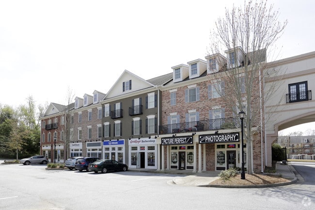
Property Record
1030 Woodstock Rd, Roswell, GA 30075
Current Lease Availabilities
NEARBY LISTINGS FOR SALE OR LEASE
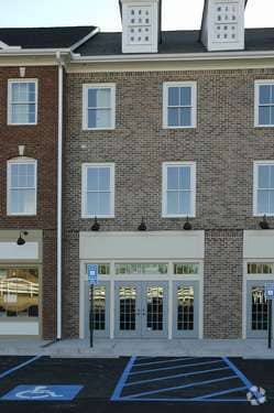
Property Detail
1030 Woodstock Rd
Commercialcondominium
Fulton
X
Georgia
13057C0375E
0.02 AC
2024
N Fulton/Forsyth County
2025
Atlanta
011419
Atlanta-Sandy Springs-Roswell, GA
900 SF
12-1540-0248-295-8
DEMOGRAPHICS near 1030 Woodstock Rd
1 Mile
3 Mile
5 Mile
2024 Total Population
4,152
50,271
150,033
2029 Population
4,212
51,327
155,121
Pop Growth 2024-2029
+ 1.45%
+ 2.10%
+ 3.39%
Average Age
46
42
41
2024 Total Households
1,713
17,991
54,694
HH Growth 2024-2029
+ 1.63%
+ 2.30%
+ 3.59%
Median Household Inc
$144,797
$149,013
$133,952
Avg Household Size
2.40
2.70
2.70
2024 Avg HH Vehicles
2.00
2.00
2.00
Median Home Value
$502,705
$496,518
$468,452
Median Year Built
1996
1989
1989
Nearby Places
- Restaurants
- Banks
- Shops
- Fitness
- Groceries
PUBLIC TRANSPORTATION
AIRPORT
Hartsfield - Jackson Atlanta International
DRIVE
WALK
Distance
Hartsfield - Jackson Atlanta International
50 min
34.9 mi
Freight Ports
Georgia Ports - Savannah
DRIVE
WALK
Distance
Georgia Ports - Savannah
313 min
274.2 mi
Nearby Properties
Address
Land Use
TOTAL SIZE
Lot Size
Zoning
Address
Land Use
TOTAL SIZE
Lot Size
Zoning
264,255 SF
51 AC
E2
Address
Land Use
TOTAL SIZE
Lot Size
Zoning
71,000 SF
48.73 AC
E1
Address
Land Use
TOTAL SIZE
Lot Size
Zoning
179,182 SF
15.06 AC
OI
Address
Land Use
TOTAL SIZE
Lot Size
Zoning
377,080 SF
19.37 AC
E1
Address
Land Use
TOTAL SIZE
Lot Size
Zoning
205,806 SF
2.01 AC
R2
Address
Land Use
TOTAL SIZE
Lot Size
Zoning
52,148 SF
6.99 AC
C1
Address
Land Use
TOTAL SIZE
Lot Size
Zoning
299,502 SF
19.77 AC
E2
Address
Land Use
TOTAL SIZE
Lot Size
Zoning
180,336 SF
14.59 AC
R1
Address
Land Use
TOTAL SIZE
Lot Size
Zoning
236,370 SF
27.52 AC
R5
Address
Land Use
TOTAL SIZE
Lot Size
Zoning
113,274 SF
14.30 AC
NRC
Address
Land Use
TOTAL SIZE
Lot Size
Zoning
95,478 SF
3 AC
Address
Land Use
TOTAL SIZE
Lot Size
Zoning
75,560 SF
10.32 AC
E2
Address
Land Use
TOTAL SIZE
Lot Size
Zoning
154,764 SF
14.70 AC
C1
Address
Land Use
TOTAL SIZE
Lot Size
Zoning
28.08 AC
E2
Address
Land Use
TOTAL SIZE
Lot Size
Zoning
25.40 AC
E1
Address
Land Use
TOTAL SIZE
Lot Size
Zoning
30.30 AC
R1
Address
Land Use
TOTAL SIZE
Lot Size
Zoning
100,696 SF
9.96 AC
E2
Address
Land Use
TOTAL SIZE
Lot Size
Zoning
82,005 SF
15.82 AC
E1
Address
Land Use
TOTAL SIZE
Lot Size
Zoning
85,000 SF
6.14 AC
AG1
Address
Land Use
TOTAL SIZE
Lot Size
Zoning
86,896 SF
8.08 AC
E2
Address
Land Use
TOTAL SIZE
Lot Size
Zoning
20.18 AC
R1
Address
Land Use
TOTAL SIZE
Lot Size
Zoning
81,095 SF
10.49 AC
C3C
Address
Land Use
TOTAL SIZE
Lot Size
Zoning
77,664 SF
10.89 AC
C2
Address
Land Use
TOTAL SIZE
Lot Size
Zoning
121,240 SF
21.04 AC
R1C
Address
Land Use
TOTAL SIZE
Lot Size
Zoning
84,670 SF
1.02 AC
OP
Address
Land Use
TOTAL SIZE
Lot Size
Zoning
59,241 SF
8.98 AC
Address
Land Use
TOTAL SIZE
Lot Size
Zoning
10.30 AC
RS30
Address
Land Use
TOTAL SIZE
Lot Size
Zoning
2,830 SF
6.61 AC
AG1
Address
Land Use
TOTAL SIZE
Lot Size
Zoning
1,359 SF
28.46 AC
RS30
Address
Land Use
TOTAL SIZE
Lot Size
Zoning
99,450 SF
14.63 AC
E1
The World's #1 Commercial Real Estate Marketplace
Connect with us
© 2025 CoStar Group
The information above has been obtained from sources believed reliable. While we do not doubt its accuracy we have not verified it and make no guarantee, warranty or representation about it. It is your responsibility to independently confirm its accuracy and completeness. Any projections, opinions, assumptions, or estimates used are for example only and do not represent the current or future performance of the property. The value of this transaction to you depends on tax and other factors which should be evaluated by your tax, financial, and legal advisors. You and your advisors should conduct a careful, independent investigation of the property to determine to your satisfaction the suitability of the property for your needs.