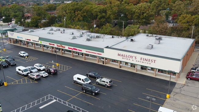
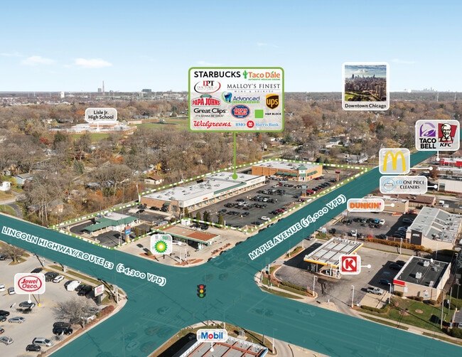
Property Record
1020 Maple Ave, Lisle, IL 60532

Current Lease Availabilities
NEARBY LISTINGS FOR SALE OR LEASE
Property Detail
1020 Maple Ave
Chicago-Naperville-Elgin, IL-IN-WI
Susman Sub
08-10-407-018
SUSMAN SUB ALL
Commercialnec
DuPage
X
Illinois
17043C0162J
2
2024
2.42 AC
2024
Western East/West Corr
846003
Chicago
DEMOGRAPHICS near 1020 Maple Ave
1 Mile
3 Mile
5 Mile
2024 Total Population
11,737
77,584
249,499
2029 Population
11,631
76,387
246,403
Pop Growth 2024-2029
(0.90%)
(1.54%)
(1.24%)
Average Age
44
41
41
2024 Total Households
5,880
32,027
97,904
HH Growth 2024-2029
(0.92%)
(1.51%)
(1.26%)
Median Household Inc
$82,902
$104,197
$106,141
Avg Household Size
1.90
2.30
2.50
2024 Avg HH Vehicles
2.00
2.00
2.00
Median Home Value
$305,023
$371,612
$394,576
Median Year Built
1975
1978
1977
Nearby Places
Map Layers
Map Styles
 Street
 Aerial
- Restaurants
- Banks
- Shops
- Fitness
- Groceries
PUBLIC TRANSPORTATION
COMMUTER RAIL
Lisle Station (Burlington Northern-Santa Fe Railway Line - Northeast Illinois Regional Commuter Railroad (Metra))
DRIVE
WALK
Distance
Lisle Station (Burlington Northern-Santa Fe Railway Line - Northeast Illinois Regional Commuter Railroad (Metra))
3 min
20 min
1.1 mi
Belmont Station (Burlington Northern-Santa Fe Railway Line - Northeast Illinois Regional Commuter Railroad (Metra))
DRIVE
WALK
Distance
Belmont Station (Burlington Northern-Santa Fe Railway Line - Northeast Illinois Regional Commuter Railroad (Metra))
7 min
2.7 mi
AIRPORT
Chicago Midway International
DRIVE
WALK
Distance
Chicago Midway International
32 min
17.0 mi
Chicago O'Hare International
DRIVE
WALK
Distance
Chicago O'Hare International
36 min
24.1 mi
Freight Ports
Port Milwaukee
DRIVE
WALK
Distance
Port Milwaukee
118 min
95.8 mi
Nearby Properties
Address
Land Use
TOTAL SIZE
Lot Size
Zoning
Address
Land Use
TOTAL SIZE
Lot Size
Zoning
83.99 AC
Address
Land Use
TOTAL SIZE
Lot Size
Zoning
12.96 AC
M
Address
Land Use
TOTAL SIZE
Lot Size
Zoning
8.08 AC
C
Address
Land Use
TOTAL SIZE
Lot Size
Zoning
5.13 AC
M
Address
Land Use
TOTAL SIZE
Lot Size
Zoning
6.03 AC
M
Address
Land Use
TOTAL SIZE
Lot Size
Zoning
20.05 AC
C
Address
Land Use
TOTAL SIZE
Lot Size
Zoning
9.18 AC
C
Address
Land Use
TOTAL SIZE
Lot Size
Zoning
8.36 AC
C
Address
Land Use
TOTAL SIZE
Lot Size
Zoning
16.28 AC
M
Address
Land Use
TOTAL SIZE
Lot Size
Zoning
19.58 AC
C
Address
Land Use
TOTAL SIZE
Lot Size
Zoning
13.53 AC
M
Address
Land Use
TOTAL SIZE
Lot Size
Zoning
2.37 AC
Address
Land Use
TOTAL SIZE
Lot Size
Zoning
13.67 AC
M
Address
Land Use
TOTAL SIZE
Lot Size
Zoning
14.68 AC
I
Address
Land Use
TOTAL SIZE
Lot Size
Zoning
13.89 AC
M
Address
Land Use
TOTAL SIZE
Lot Size
Zoning
19.02 AC
M
Address
Land Use
TOTAL SIZE
Lot Size
Zoning
8.53 AC
M
Address
Land Use
TOTAL SIZE
Lot Size
Zoning
13.27 AC
M
Address
Land Use
TOTAL SIZE
Lot Size
Zoning
13.44 AC
C
Address
Land Use
TOTAL SIZE
Lot Size
Zoning
18.95 AC
Address
Land Use
TOTAL SIZE
Lot Size
Zoning
164,787 SF
8.20 AC
Address
Land Use
TOTAL SIZE
Lot Size
Zoning
25.64 AC
Address
Land Use
TOTAL SIZE
Lot Size
Zoning
47.33 AC
Address
Land Use
TOTAL SIZE
Lot Size
Zoning
9.98 AC
C
Address
Land Use
TOTAL SIZE
Lot Size
Zoning
2.26 AC
C
Address
Land Use
TOTAL SIZE
Lot Size
Zoning
11.87 AC
Address
Land Use
TOTAL SIZE
Lot Size
Zoning
8.34 AC
C
Address
Land Use
TOTAL SIZE
Lot Size
Zoning
5.91 AC
Address
Land Use
TOTAL SIZE
Lot Size
Zoning
12.94 AC
M
Address
Land Use
TOTAL SIZE
Lot Size
Zoning
6.37 AC
C
The World's #1 Commercial Real Estate Marketplace
Connect with us
© 2025 CoStar Group
The information above has been obtained from sources believed reliable. While we do not doubt its accuracy we have not verified it and make no guarantee, warranty or representation about it. It is your responsibility to independently confirm its accuracy and completeness. Any projections, opinions, assumptions, or estimates used are for example only and do not represent the current or future performance of the property. The value of this transaction to you depends on tax and other factors which should be evaluated by your tax, financial, and legal advisors. You and your advisors should conduct a careful, independent investigation of the property to determine to your satisfaction the suitability of the property for your needs.