Property Record
1020 Far Hills Dr, New Freedom, PA 17349


NEARBY LISTINGS FOR SALE OR LEASE
Property Detail
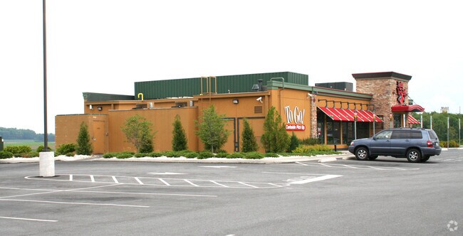
1020 Far Hills Dr
32-000-CJ-0037.T0-00000
Stonebridge Business Park
Restaurantbuilding
LOT 17; PB SS-423
X
York
42133C0468F
Pennsylvania
2025
1.94 AC
2025
York County
023904
Philadelphia
4,768 SF
York-Hanover, PA
DEMOGRAPHICS near 1020 Far Hills Dr
1 Mile
3 Mile
5 Mile
2024 Total Population
2,749
12,490
29,397
2029 Population
2,826
12,841
30,101
Pop Growth 2024-2029
+ 2.80%
+ 2.81%
+ 2.39%
Average Age
43
45
44
2024 Total Households
1,070
5,050
11,563
HH Growth 2024-2029
+ 2.80%
+ 2.89%
+ 2.49%
Median Household Inc
$93,681
$92,015
$92,902
Avg Household Size
2.60
2.40
2.50
2024 Avg HH Vehicles
2.00
2.00
2.00
Median Home Value
$281,639
$285,424
$285,687
Median Year Built
1985
1984
1983
Nearby Places
Map Layers
Map Styles
 Street
 Aerial
- Restaurants
- Banks
- Shops
- Fitness
- Groceries
PUBLIC TRANSPORTATION
AIRPORT
Harrisburg International
DRIVE
WALK
Distance
Harrisburg International
62 min
45.9 mi
Freight Ports
Port of Baltimore
DRIVE
WALK
Distance
Port of Baltimore
60 min
41.2 mi
Nearby Properties
Address
Land Use
TOTAL SIZE
Lot Size
Zoning
Address
Land Use
TOTAL SIZE
Lot Size
Zoning
58.61 AC
I
Address
Land Use
TOTAL SIZE
Lot Size
Zoning
10.36 AC
CBD
Address
Land Use
TOTAL SIZE
Lot Size
Zoning
156,412 SF
22.08 AC
C
Address
Land Use
TOTAL SIZE
Lot Size
Zoning
86,664 SF
18.13 AC
C
Address
Land Use
TOTAL SIZE
Lot Size
Zoning
68,516 SF
12.42 AC
C
Address
Land Use
TOTAL SIZE
Lot Size
Zoning
103,995 SF
17.86 AC
C
Address
Land Use
TOTAL SIZE
Lot Size
Zoning
3.30 AC
Address
Land Use
TOTAL SIZE
Lot Size
Zoning
41,054 SF
4.22 AC
C
Address
Land Use
TOTAL SIZE
Lot Size
Zoning
5.51 AC
Address
Land Use
TOTAL SIZE
Lot Size
Zoning
10,658 SF
5.44 AC
AG
Address
Land Use
TOTAL SIZE
Lot Size
Zoning
26,300 SF
22.03 AC
CM
Address
Land Use
TOTAL SIZE
Lot Size
Zoning
11,880 SF
13.54 AC
C
Address
Land Use
TOTAL SIZE
Lot Size
Zoning
45,900 SF
11.97 AC
AG
Address
Land Use
TOTAL SIZE
Lot Size
Zoning
47,640 SF
6.33 AC
RS
Address
Land Use
TOTAL SIZE
Lot Size
Zoning
2,352 SF
77 AC
CV
Address
Land Use
TOTAL SIZE
Lot Size
Zoning
35,068 SF
11.88 AC
A
Address
Land Use
TOTAL SIZE
Lot Size
Zoning
89,369 SF
6.59 AC
I
Address
Land Use
TOTAL SIZE
Lot Size
Zoning
21,751 SF
16.07 AC
I
Address
Land Use
TOTAL SIZE
Lot Size
Zoning
35,550 SF
4.56 AC
I
Address
Land Use
TOTAL SIZE
Lot Size
Zoning
40,978 SF
2.91 AC
RS
Address
Land Use
TOTAL SIZE
Lot Size
Zoning
21,056 SF
4.33 AC
C
Address
Land Use
TOTAL SIZE
Lot Size
Zoning
1.55 AC
Address
Land Use
TOTAL SIZE
Lot Size
Zoning
29,600 SF
3.19 AC
C
Address
Land Use
TOTAL SIZE
Lot Size
Zoning
20,746 SF
6.09 AC
C
Address
Land Use
TOTAL SIZE
Lot Size
Zoning
84,460 SF
10.04 AC
RS
Address
Land Use
TOTAL SIZE
Lot Size
Zoning
31,389 SF
2.17 AC
RS
Address
Land Use
TOTAL SIZE
Lot Size
Zoning
2,820 SF
4.54 AC
CN
Address
Land Use
TOTAL SIZE
Lot Size
Zoning
10,740 SF
4.50 AC
I
Address
Land Use
TOTAL SIZE
Lot Size
Zoning
20,000 SF
4.29 AC
I
Address
Land Use
TOTAL SIZE
Lot Size
Zoning
57,768 SF
3.70 AC
ID
The World's #1 Commercial Real Estate Marketplace
Connect with us
© 2026 CoStar Group
The information above has been obtained from sources believed reliable. While we do not doubt its accuracy we have not verified it and make no guarantee, warranty or representation about it. It is your responsibility to independently confirm its accuracy and completeness. Any projections, opinions, assumptions, or estimates used are for example only and do not represent the current or future performance of the property. The value of this transaction to you depends on tax and other factors which should be evaluated by your tax, financial, and legal advisors. You and your advisors should conduct a careful, independent investigation of the property to determine to your satisfaction the suitability of the property for your needs.