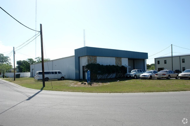
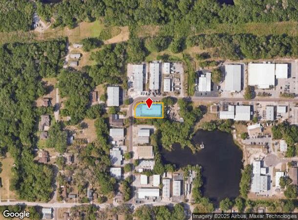
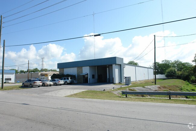
Property Record
1020 Harbor Lake Dr, Safety Harbor, FL 34695
NEARBY LISTINGS FOR SALE OR LEASE
Property Detail
1020 Harbor Lake Dr
Tampa-St. Petersburg-Clearwater, FL
Harbor Lake Industrial
33-28-16-36225-000-0330
HARBOR LAKE INDUSTRIAL PARK LOT 33
Warehouse
Pinellas
X
Florida
12103C0127H
33
2024
0.46 AC
2025
North Pinellas
026817
Tampa/St Petersburg
8,160 SF
DEMOGRAPHICS near 1020 Harbor Lake Dr
1 Mile
3 Mile
5 Mile
2024 Total Population
8,832
66,056
183,475
2029 Population
8,751
66,011
184,185
Pop Growth 2024-2029
(0.92%)
(0.07%)
+ 0.39%
Average Age
45
48
46
2024 Total Households
3,720
30,803
83,584
HH Growth 2024-2029
(1.21%)
(0.22%)
+ 0.28%
Median Household Inc
$101,394
$61,579
$61,268
Avg Household Size
2.30
2.10
2.10
2024 Avg HH Vehicles
2.00
2.00
2.00
Median Home Value
$417,801
$269,703
$270,057
Median Year Built
1984
1980
1980
Nearby Places
Map Layers
Map Styles
 Street
 Aerial
- Restaurants
- Banks
- Shops
- Fitness
- Groceries
PUBLIC TRANSPORTATION
AIRPORT
St Pete-Clearwater International
DRIVE
WALK
Distance
St Pete-Clearwater International
14 min
7.7 mi
Tampa International
DRIVE
WALK
Distance
Tampa International
27 min
15.6 mi
Freight Ports
Port of Tampa Bay
DRIVE
WALK
Distance
Port of Tampa Bay
41 min
24.1 mi
Nearby Properties
Address
Land Use
TOTAL SIZE
Lot Size
Zoning
Address
Land Use
TOTAL SIZE
Lot Size
Zoning
661,982 SF
19.26 AC
Address
Land Use
TOTAL SIZE
Lot Size
Zoning
724,220 SF
22.95 AC
Address
Land Use
TOTAL SIZE
Lot Size
Zoning
563,328 SF
27.34 AC
Address
Land Use
TOTAL SIZE
Lot Size
Zoning
435,202 SF
9.80 AC
R3
Address
Land Use
TOTAL SIZE
Lot Size
Zoning
452,179 SF
5.75 AC
R4
Address
Land Use
TOTAL SIZE
Lot Size
Zoning
460,041 SF
44.28 AC
Address
Land Use
TOTAL SIZE
Lot Size
Zoning
288,467 SF
43.51 AC
Address
Land Use
TOTAL SIZE
Lot Size
Zoning
305,970 SF
39.74 AC
Address
Land Use
TOTAL SIZE
Lot Size
Zoning
352,647 SF
14.88 AC
Address
Land Use
TOTAL SIZE
Lot Size
Zoning
356,262 SF
15.48 AC
Address
Land Use
TOTAL SIZE
Lot Size
Zoning
406,729 SF
29.79 AC
CP1
Address
Land Use
TOTAL SIZE
Lot Size
Zoning
171,150 SF
17.58 AC
Address
Land Use
TOTAL SIZE
Lot Size
Zoning
326,008 SF
53.12 AC
Address
Land Use
TOTAL SIZE
Lot Size
Zoning
662,010 SF
33.76 AC
Address
Land Use
TOTAL SIZE
Lot Size
Zoning
236,972 SF
19.07 AC
Address
Land Use
TOTAL SIZE
Lot Size
Zoning
492,747 SF
19.89 AC
Address
Land Use
TOTAL SIZE
Lot Size
Zoning
321,395 SF
25.22 AC
Address
Land Use
TOTAL SIZE
Lot Size
Zoning
223,944 SF
12.13 AC
Address
Land Use
TOTAL SIZE
Lot Size
Zoning
239,340 SF
17.27 AC
Address
Land Use
TOTAL SIZE
Lot Size
Zoning
258,472 SF
18.23 AC
Address
Land Use
TOTAL SIZE
Lot Size
Zoning
251,016 SF
10.10 AC
AE
Address
Land Use
TOTAL SIZE
Lot Size
Zoning
226,562 SF
11.08 AC
Address
Land Use
TOTAL SIZE
Lot Size
Zoning
215,081 SF
16.60 AC
Address
Land Use
TOTAL SIZE
Lot Size
Zoning
208,637 SF
16.83 AC
M1
Address
Land Use
TOTAL SIZE
Lot Size
Zoning
160,827 SF
20.22 AC
AE
Address
Land Use
TOTAL SIZE
Lot Size
Zoning
176,724 SF
10.92 AC
Address
Land Use
TOTAL SIZE
Lot Size
Zoning
181,169 SF
21.90 AC
AE
Address
Land Use
TOTAL SIZE
Lot Size
Zoning
53,208 SF
38.71 AC
Address
Land Use
TOTAL SIZE
Lot Size
Zoning
131,291 SF
4.24 AC
Address
Land Use
TOTAL SIZE
Lot Size
Zoning
256,181 SF
12.71 AC
The World's #1 Commercial Real Estate Marketplace
Connect with us
© 2025 CoStar Group
The information above has been obtained from sources believed reliable. While we do not doubt its accuracy we have not verified it and make no guarantee, warranty or representation about it. It is your responsibility to independently confirm its accuracy and completeness. Any projections, opinions, assumptions, or estimates used are for example only and do not represent the current or future performance of the property. The value of this transaction to you depends on tax and other factors which should be evaluated by your tax, financial, and legal advisors. You and your advisors should conduct a careful, independent investigation of the property to determine to your satisfaction the suitability of the property for your needs.