Property Record
1020 Malibu Way, Homestead, FL 33033
NEARBY LISTINGS FOR SALE OR LEASE
Property Detail
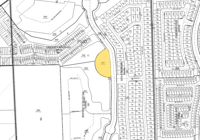
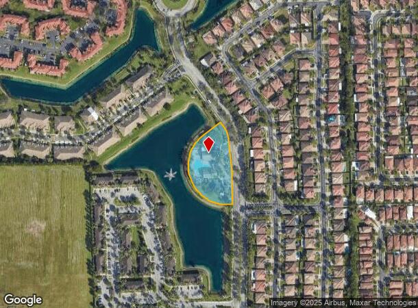
1020 Malibu Way
10-7910-009-0030
Malibu Way
Recreationalentertainmentgeneral
MALIBU WAY PB 162-39 T-21793 TR C (REC SITE) LOT SIZE 71137 SQ FT FAU 10 7910 000 0080 & 0091 OR 21031-3411 022003 2 (157)
AH
Miami/Dade
12086C0731L
Florida
0
1.63 AC
2025
South Dade
011009
South Florida
6,297 SF
Miami-Miami Beach-Kendall, FL
DEMOGRAPHICS near 1020 Malibu Way
1 Mile
3 Mile
5 Mile
2024 Total Population
21,120
105,255
179,275
2029 Population
20,451
103,326
176,207
Pop Growth 2024-2029
(3.17%)
(1.83%)
(1.71%)
Average Age
35
36
35
2024 Total Households
6,103
31,704
53,315
HH Growth 2024-2029
(3.67%)
(2.28%)
(2.14%)
Median Household Inc
$70,036
$57,338
$55,433
Avg Household Size
3.30
3.20
3.20
2024 Avg HH Vehicles
2.00
2.00
2.00
Median Home Value
$309,177
$304,076
$308,675
Median Year Built
2004
2001
1999
Nearby Places
Map Layers
Map Styles
 Street
 Aerial
- Restaurants
- Banks
- Shops
- Fitness
- Groceries
PUBLIC TRANSPORTATION
AIRPORT
Miami International
DRIVE
WALK
Distance
Miami International
43 min
29.6 mi
Freight Ports
Port of Miami
DRIVE
WALK
Distance
Port of Miami
52 min
36.7 mi
Nearby Properties
Address
Land Use
TOTAL SIZE
Lot Size
Zoning
Address
Land Use
TOTAL SIZE
Lot Size
Zoning
487,531 SF
60 AC
9300
Address
Land Use
TOTAL SIZE
Lot Size
Zoning
1,348,296 SF
76.88 AC
7600
Address
Land Use
TOTAL SIZE
Lot Size
Zoning
289,905 SF
29.74 AC
6500
Address
Land Use
TOTAL SIZE
Lot Size
Zoning
321,122 SF
7.31 AC
3161
Address
Land Use
TOTAL SIZE
Lot Size
Zoning
313,656 SF
10.71 AC
3900
Address
Land Use
TOTAL SIZE
Lot Size
Zoning
1 SF
20.93 AC
9000
Address
Land Use
TOTAL SIZE
Lot Size
Zoning
149,022 SF
34.85 AC
9300
Address
Land Use
TOTAL SIZE
Lot Size
Zoning
253,088 SF
2.90 AC
6072
Address
Land Use
TOTAL SIZE
Lot Size
Zoning
225,691 SF
8.22 AC
3900
Address
Land Use
TOTAL SIZE
Lot Size
Zoning
228,908 SF
65.07 AC
3050
Address
Land Use
TOTAL SIZE
Lot Size
Zoning
216,282 SF
20.04 AC
6300
Address
Land Use
TOTAL SIZE
Lot Size
Zoning
183,244 SF
4 AC
6500
Address
Land Use
TOTAL SIZE
Lot Size
Zoning
183,940 SF
4.80 AC
3050
Address
Land Use
TOTAL SIZE
Lot Size
Zoning
280,512 SF
44.85 AC
7600
Address
Land Use
TOTAL SIZE
Lot Size
Zoning
11,341 SF
212.73 AC
0100
Address
Land Use
TOTAL SIZE
Lot Size
Zoning
302,948 SF
142.64 AC
9300
Address
Land Use
TOTAL SIZE
Lot Size
Zoning
232,810 SF
24.61 AC
3800
Address
Land Use
TOTAL SIZE
Lot Size
Zoning
183,633 SF
3.78 AC
3802
Address
Land Use
TOTAL SIZE
Lot Size
Zoning
199,350 SF
3.75 AC
3161
Address
Land Use
TOTAL SIZE
Lot Size
Zoning
213,133 SF
138.20 AC
9300
Address
Land Use
TOTAL SIZE
Lot Size
Zoning
237,527 SF
34.14 AC
9300
Address
Land Use
TOTAL SIZE
Lot Size
Zoning
409,347 SF
33.88 AC
3000
Address
Land Use
TOTAL SIZE
Lot Size
Zoning
179,608 SF
8.06 AC
9300
Address
Land Use
TOTAL SIZE
Lot Size
Zoning
144,931 SF
10.69 AC
6200
Address
Land Use
TOTAL SIZE
Lot Size
Zoning
119,534 SF
8.55 AC
6200
Address
Land Use
TOTAL SIZE
Lot Size
Zoning
374,632 SF
23.28 AC
3000
Address
Land Use
TOTAL SIZE
Lot Size
Zoning
172,811 SF
22.02 AC
9300
Address
Land Use
TOTAL SIZE
Lot Size
Zoning
1 SF
365.68 AC
9000
Address
Land Use
TOTAL SIZE
Lot Size
Zoning
159,298 SF
4.93 AC
5300
The World's #1 Commercial Real Estate Marketplace
Connect with us
© 2025 CoStar Group
The information above has been obtained from sources believed reliable. While we do not doubt its accuracy we have not verified it and make no guarantee, warranty or representation about it. It is your responsibility to independently confirm its accuracy and completeness. Any projections, opinions, assumptions, or estimates used are for example only and do not represent the current or future performance of the property. The value of this transaction to you depends on tax and other factors which should be evaluated by your tax, financial, and legal advisors. You and your advisors should conduct a careful, independent investigation of the property to determine to your satisfaction the suitability of the property for your needs.