Property Record
1020 N Jeffers St, North Platte, NE 69101


NEARBY LISTINGS FOR SALE OR LEASE
-
-
View all North Platte listings for sale on LoopNet.com
Property Detail
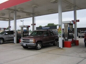
1020 N Jeffers St
0046207.10
Wagner Family Replat
Conveniencestore
WAGNER FAMILY REPLAT (OF WAGNER OIL REP. LT 1 OF O.T. 3 & 4 38) LOT 1; MAP NUMBER: 0000-00-0-00000-000-6225
X
Lincoln
31111C0620C
Nebraska
2024
0.63 AC
2024
I-80 Corridor
959900
Other Market Areas
2,814 SF
North Platte, NE
DEMOGRAPHICS near 1020 N Jeffers St
1 Mile
3 Mile
5 Mile
2024 Total Population
5,739
23,188
24,635
2029 Population
5,569
22,373
23,751
Pop Growth 2024-2029
(2.96%)
(3.51%)
(3.59%)
Average Age
38
41
41
2024 Total Households
2,409
10,129
10,706
HH Growth 2024-2029
(2.91%)
(3.51%)
(3.58%)
Median Household Inc
$48,783
$57,207
$58,304
Avg Household Size
2.30
2.20
2.20
2024 Avg HH Vehicles
2.00
2.00
2.00
Median Home Value
$115,694
$152,885
$157,899
Median Year Built
1955
1969
1970
Nearby Places
Map Layers
Map Styles
 Street
 Aerial
- Restaurants
- Banks
- Shops
- Fitness
- Groceries
Nearby Properties
Address
Land Use
TOTAL SIZE
Lot Size
Zoning
Address
Land Use
TOTAL SIZE
Lot Size
Zoning
78.13 AC
COMMERCIAL
Address
Land Use
TOTAL SIZE
Lot Size
Zoning
67,559 SF
2.22 AC
COMMERCIAL
Address
Land Use
TOTAL SIZE
Lot Size
Zoning
65,574 SF
6.82 AC
COMMERCIAL
Address
Land Use
TOTAL SIZE
Lot Size
Zoning
69,798 SF
COMMERCIAL
Address
Land Use
TOTAL SIZE
Lot Size
Zoning
2,537 SF
7.32 AC
COMMERCIAL
Address
Land Use
TOTAL SIZE
Lot Size
Zoning
200,543 SF
20.97 AC
COMMERCIAL
Address
Land Use
TOTAL SIZE
Lot Size
Zoning
47,641 SF
1.43 AC
COMMERCIAL
Address
Land Use
TOTAL SIZE
Lot Size
Zoning
74,430 SF
5.47 AC
COMMERCIAL
Address
Land Use
TOTAL SIZE
Lot Size
Zoning
9,042 SF
4.97 AC
COMMERCIAL
Address
Land Use
TOTAL SIZE
Lot Size
Zoning
90,959 SF
4.19 AC
COMMERCIAL
Address
Land Use
TOTAL SIZE
Lot Size
Zoning
60,014 SF
2.47 AC
COMMERCIAL
Address
Land Use
TOTAL SIZE
Lot Size
Zoning
7,536 SF
2.64 AC
COMMERCIAL
Address
Land Use
TOTAL SIZE
Lot Size
Zoning
87,987 SF
4.04 AC
COMMERCIAL
Address
Land Use
TOTAL SIZE
Lot Size
Zoning
44,215 SF
2.96 AC
COMMERCIAL
Address
Land Use
TOTAL SIZE
Lot Size
Zoning
111,422 SF
4.30 AC
COMMERCIAL
Address
Land Use
TOTAL SIZE
Lot Size
Zoning
46,814 SF
1.96 AC
COMMERCIAL
Address
Land Use
TOTAL SIZE
Lot Size
Zoning
14,510 SF
1.82 AC
COMMERCIAL
Address
Land Use
TOTAL SIZE
Lot Size
Zoning
22,574 SF
0.35 AC
COMMERCIAL
Address
Land Use
TOTAL SIZE
Lot Size
Zoning
1,440 SF
COMMERCIAL
Address
Land Use
TOTAL SIZE
Lot Size
Zoning
35,132 SF
1.70 AC
COMMERCIAL
Address
Land Use
TOTAL SIZE
Lot Size
Zoning
39,291 SF
1.52 AC
COMMERCIAL
Address
Land Use
TOTAL SIZE
Lot Size
Zoning
38,918 SF
1.70 AC
COMMERCIAL
Address
Land Use
TOTAL SIZE
Lot Size
Zoning
34,446 SF
5.64 AC
COMMERCIAL
Address
Land Use
TOTAL SIZE
Lot Size
Zoning
17,168 SF
3.62 AC
COMMERCIAL
Address
Land Use
TOTAL SIZE
Lot Size
Zoning
53,905 SF
3.42 AC
COMMERCIAL
Address
Land Use
TOTAL SIZE
Lot Size
Zoning
58,393 SF
2.02 AC
COMMERCIAL
Address
Land Use
TOTAL SIZE
Lot Size
Zoning
22,618 SF
5.84 AC
COMMERCIAL
Address
Land Use
TOTAL SIZE
Lot Size
Zoning
19,836 SF
5.12 AC
COMMERCIAL
Address
Land Use
TOTAL SIZE
Lot Size
Zoning
14,125 SF
4.69 AC
COMMERCIAL
The World's #1 Commercial Real Estate Marketplace
Connect with us
© 2026 CoStar Group
The information above has been obtained from sources believed reliable. While we do not doubt its accuracy we have not verified it and make no guarantee, warranty or representation about it. It is your responsibility to independently confirm its accuracy and completeness. Any projections, opinions, assumptions, or estimates used are for example only and do not represent the current or future performance of the property. The value of this transaction to you depends on tax and other factors which should be evaluated by your tax, financial, and legal advisors. You and your advisors should conduct a careful, independent investigation of the property to determine to your satisfaction the suitability of the property for your needs.