Property Record
1020 N River Rd N, Rochester, WI 53167

NEARBY LISTINGS FOR SALE OR LEASE
-
-
View all Rochester listings for sale on LoopNet.com
Property Detail
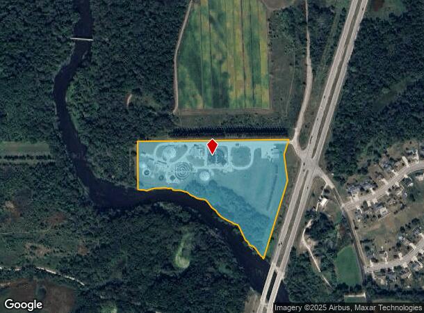
1020 N River Rd N
176-031914019000
PT NW1/4 LY W OF HWY 36,N&E OF FOX RIVER IN GL 1 &.23A IN NE1/4 EXC #2137557 PT TO 014031914019010 IN 07 FOR 08 ROLL **TOTAL
Vacantlandnec
Racine
AE
Wisconsin
55101C0151E
17.34 AC
2024
Racine West
2024
Milwaukee/Madison
002701
Racine, WI
DEMOGRAPHICS near 1020 N River Rd N
1 Mile
3 Mile
5 Mile
2024 Total Population
1,144
10,043
27,263
2029 Population
1,121
10,026
27,176
Pop Growth 2024-2029
(2.01%)
(0.17%)
(0.32%)
Average Age
45
43
42
2024 Total Households
450
4,061
10,977
HH Growth 2024-2029
(2.00%)
(0.15%)
(0.34%)
Median Household Inc
$89,307
$88,135
$87,312
Avg Household Size
2.50
2.40
2.40
2024 Avg HH Vehicles
2.00
2.00
2.00
Median Home Value
$356,626
$324,463
$312,400
Median Year Built
1984
1980
1979
Nearby Places
Map Layers
Map Styles
 Street
 Aerial
- Restaurants
- Banks
- Shops
- Fitness
- Groceries
PUBLIC TRANSPORTATION
AIRPORT
General Mitchell International
DRIVE
WALK
Distance
General Mitchell International
43 min
25.1 mi
Freight Ports
Port Milwaukee
DRIVE
WALK
Distance
Port Milwaukee
43 min
28.0 mi
Nearby Properties
Address
Land Use
TOTAL SIZE
Lot Size
Zoning
Address
Land Use
TOTAL SIZE
Lot Size
Zoning
6.08 AC
Address
Land Use
TOTAL SIZE
Lot Size
Zoning
155,078 SF
27.98 AC
Address
Land Use
TOTAL SIZE
Lot Size
Zoning
22.08 AC
Address
Land Use
TOTAL SIZE
Lot Size
Zoning
5.24 AC
Address
Land Use
TOTAL SIZE
Lot Size
Zoning
12.03 AC
Address
Land Use
TOTAL SIZE
Lot Size
Zoning
22,670 SF
4.22 AC
Address
Land Use
TOTAL SIZE
Lot Size
Zoning
24.67 AC
Address
Land Use
TOTAL SIZE
Lot Size
Zoning
1.66 AC
Address
Land Use
TOTAL SIZE
Lot Size
Zoning
16,573 SF
0.35 AC
Address
Land Use
TOTAL SIZE
Lot Size
Zoning
32,400 SF
22.55 AC
Address
Land Use
TOTAL SIZE
Lot Size
Zoning
1.30 AC
Address
Land Use
TOTAL SIZE
Lot Size
Zoning
55.76 AC
Address
Land Use
TOTAL SIZE
Lot Size
Zoning
22,244 SF
2.05 AC
Address
Land Use
TOTAL SIZE
Lot Size
Zoning
15,540 SF
2.19 AC
Address
Land Use
TOTAL SIZE
Lot Size
Zoning
23.11 AC
Address
Land Use
TOTAL SIZE
Lot Size
Zoning
107.06 AC
Address
Land Use
TOTAL SIZE
Lot Size
Zoning
3.69 AC
Address
Land Use
TOTAL SIZE
Lot Size
Zoning
4.78 AC
Address
Land Use
TOTAL SIZE
Lot Size
Zoning
27,940 SF
5.58 AC
Address
Land Use
TOTAL SIZE
Lot Size
Zoning
1.53 AC
Address
Land Use
TOTAL SIZE
Lot Size
Zoning
2,792 SF
16.50 AC
Address
Land Use
TOTAL SIZE
Lot Size
Zoning
0.05 AC
Address
Land Use
TOTAL SIZE
Lot Size
Zoning
9,275 SF
1.58 AC
Address
Land Use
TOTAL SIZE
Lot Size
Zoning
1.46 AC
Address
Land Use
TOTAL SIZE
Lot Size
Zoning
Address
Land Use
TOTAL SIZE
Lot Size
Zoning
Address
Land Use
TOTAL SIZE
Lot Size
Zoning
1.90 AC
Address
Land Use
TOTAL SIZE
Lot Size
Zoning
4,800 SF
7.05 AC
Address
Land Use
TOTAL SIZE
Lot Size
Zoning
2.55 AC
Address
Land Use
TOTAL SIZE
Lot Size
Zoning
2.22 AC
The World's #1 Commercial Real Estate Marketplace
Connect with us
© 2025 CoStar Group
The information above has been obtained from sources believed reliable. While we do not doubt its accuracy we have not verified it and make no guarantee, warranty or representation about it. It is your responsibility to independently confirm its accuracy and completeness. Any projections, opinions, assumptions, or estimates used are for example only and do not represent the current or future performance of the property. The value of this transaction to you depends on tax and other factors which should be evaluated by your tax, financial, and legal advisors. You and your advisors should conduct a careful, independent investigation of the property to determine to your satisfaction the suitability of the property for your needs.